Matucana district
| Matucana district | |
|---|---|
 The district of Matucana is north-central in the province of Huarochirí (marked in red) |
|
| Basic data | |
| Country | Peru |
| region | Lima |
| province | Huarochirí |
| Seat | Matucana |
| surface | 179.4 km² |
| Residents | 4058 (2017) |
| density | 23 inhabitants per km² |
| ISO 3166-2 | PE-LIM |
| Website | munimatucana.gob.pe (Spanish) |
| politics | |
| Alcaldesa Provincial | Eveling Geovanna Feliciano Ordoñez (2019-2022) |
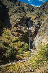
| Antakallo waterfall | |
Coordinates: 11 ° 51 ′ S , 76 ° 23 ′ W
The Matucana District is located in the Huarochirí Province of the Lima Region in the central west of Peru . The district has an area of 179.44 km². At the 2017 census, 4058 inhabitants lived in the district. In 1993 the population was 5700, in 2007 4508. The district administration is located in the provincial capital of Matucana, 2378 m high .
Geographical location
The Matucana district is located north-central in the Huarochirí province. It is located in the Peruvian Western Cordillera on the upper reaches of the Río Rímac , which flows through it in a south-westerly direction. A freight line runs through the Río Rímac valley.
The district of Matucana borders in the northwest with the districts San Mateo de Otao and San Juan de Iris , in the north with the district Carampoma , in the east with the district San Mateo , in the southeast with the district San Damián and in the west with the district Surco .
Web links
- Municipalidad Provincial de Huarochirí - Matucana
- Peru: Region Lima (provinces and districts) at www.citypopulation.de
