Molinopampa District
| Molinopampa District | |
|---|---|
| Basic data | |
| Country | Peru |
| region | Amazon |
| province | Chachapoyas |
| Seat | Molinopampa |
| surface | 333.9 km² |
| Residents | 2176 (2017) |
| density | 6.5 inhabitants per km² |
| founding | February 5, 1861 |
| ISO 3166-2 | PE-AMA |
| politics | |
| Alcalde District | Keni Roy Pinedo Mori (2019-2022) |
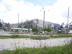
| The central square of Molinopampa | |
Coordinates: 6 ° 13 ′ S , 77 ° 36 ′ W
The Molinopampa District is located in the Chachapoyas Province in the Amazonas region . It has an area of 333.86 km². In the 2017 census the population was 2176. In 1993 it was 2427, in 2007 it was 2501. The district capital is the town of Molinopampa .
Capital
The name of the district capital Molinopampa is made up of two words, from Molino , which means “mill” in Spanish, and from Pampa , which simply means an undeveloped area of indefinite size. This name comes from the fact that Molinopampa, which lies directly on the river Sonche , which later flows into the Río Utcubamba , housed one of the most important water-powered flour mills in the area until a few years ago.
Today Molinopampa is known for its abundance of fish.
As in the rest of the area, Molinopampa also has ruins of the Chachapoya culture .
Geographical location
In the north, the Molinopampa district borders on the Quinjalca and Granada districts , in the east on the Vista Alegre and Mariscal Benavides districts , in the southeast on the Longar district and in the southwest on the Cheto district .
The Molinopampa district begins on the banks of the Sonche river and goes from here to the high mountains.
Web links
- Peru: Amazonas region (provinces and districts) at www.citypopulation.de


