Granada district
| Granada district | |
|---|---|
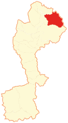
 Location of the district in Chachapoyas Province |
|
| Basic data | |
| Country | Peru |
| region | Amazon |
| province | Chachapoyas |
| Seat | Granada |
| surface | 171 km² |
| Residents | 480 (2017) |
| density | 2.8 inhabitants per km² |
| founding | November 3, 1933 |
| ISO 3166-2 | PE-AMA |
| Website | www.munigranada.gob.pe (Spanish) |
| politics | |
| Alcalde District | Samuel Canlla Gómez (2019-2022) |
Coordinates: 6 ° 3 ′ S , 77 ° 37 ′ W
The Granada district is one of 21 districts of the Chachapoyas Province in the Amazonas region . The district has an area of 171 km². At the 2017 census, 480 people lived in the district. In 1993 the population was 551, in 2007 it was 426.
geography
The Granada district is located in the high mountains of the Andes . Only parts of the district are accessible by road, most of them can only be reached on foot or by mule. The Granada district is located on the northeastern border of the Chachapoyas province.
In the north, the Granada district borders on the Olleros district , in the east on the San Martín region , the Vista Alegre district and the Mariscal Benavides district , in the southeast on the San Nicolás district , and in the southwest on the Quinjalca district .
height
The entire district is located in the high mountains, the district capital is at an altitude of 3013 m above sea level.
tourism
In addition to the annual village festival from June 23rd to 30th, the ruins of Granada and the Río Imaza are particularly attractive. The latter invites you to fish for trout.
Villages and homesteads in the Granada district
- Airecampo
- Calviche
- Camellan
- Chillan
- Diosan
- Gorge
- Granada
- Guillipcha
- Isco
- San Juan de Eñara
- Saviajcha
- Shundura
- Sugmal
swell
- Instituto Nacional de Estadistica e Informatica - Banco de Información Distrital
- Municipalidad Distrital de Granada
See also
Web links
- Peru: Amazonas region (provinces and districts) at www.citypopulation.de