Magdalena District (Chachapoyas)
| Magdalena district | |
|---|---|
| Basic data | |
| Country | Peru |
| region | Amazon |
| province | Chachapoyas |
| Seat | Magdalena |
| surface | 135.5 km² |
| Residents | 852 (2017) |
| density | 6.3 inhabitants per km² |
| founding | November 3, 1933 |
| ISO 3166-2 | PE-AMA |
| Website | www.munimagdalenamazonas.gob.pe (Spanish) |
| politics | |
| Alcalde District | José Luis Tenorio Tauma (2019-2022) |
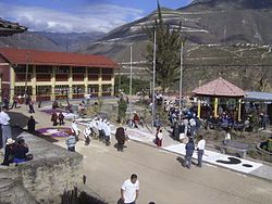
| Village festival in Magdalena | |
Coordinates: 6 ° 28 ′ S , 77 ° 29 ′ W
The Magdalena District is one of 21 districts of the province of Chachapoyas in Amazonas region . It has an area of 135 km². In the 2017 census the population was 852. In 1993 it was 1134, in 2007 it was 880. The administrative center is Magdalena .
Magdalena is located where the mountains flatten towards the Utcubamba River . From Magdalena you have a wonderful view of Kuelap . You can get to Magdalena by car from Chachapoyas (Peru) .
Geographical location
In the north, the Magdalena district borders on the San Isidro de Maino and Levanto districts , in the east on the Rodríguez de Mendoza province , in the south on the La Jalca district , in the southwest on the San Juan de Lopecancha district ( Luya province ) and in the To the west, the Utcubamba River marks the border with the Tingo District (also in the Luya Province).
Villages and homesteads in the Magdalena district
- Agua Loca
- Ajingopampa
- Cangall
- Cedropampa
- Chillca
- Chillo
- Chosayacu
- Condechaca
- Cuchapampa
- Cuchipia
- Cuyapina
- Desengado
- Gacay
- Gosgarrillan
- Gupis
- Huilllin
- Laumal
- Limón
- Llaumote
- Lluycunga
- Luin
- Magdalena
- Nogal Pampas
- Olanya
- Oncecha
- Paguana
- Parsul
- Penca Pampas
- Quilcalon
- Sahual
- Shahuante
- Yurac Yacu
Web links
- Municipalidad Distrital de Magdalena
- Peru: Amazonas region (provinces and districts) at www.citypopulation.de
