Paccaritambo district
| Paccaritambo district | |
|---|---|
 The district of Paccaritambo is located in the central north of the province of Paruro (marked in red) |
|
| Basic data | |
| Country | Peru |
| region | Cusco |
| province | Paruro |
| Seat | Paccaritambo |
| surface | 142 km² |
| Residents | 2162 (2017) |
| density | 15 inhabitants per km² |
| founding | October 22, 1963 |
| ISO 3166-2 | PE-CUS |
| politics | |
| Alcalde District | Mario Sullca Quispe (2019-2022) |
| Political party | Restauración Nacional |
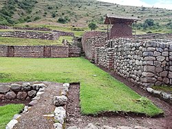
| archaeological site of Maukallacta | |
Coordinates: 13 ° 45 ′ S , 71 ° 57 ′ W
The Paccaritambo District is located in the Paruro Province in the Cusco region in south-central Peru . The district was established on October 22, 1963. It has an area of 142 km². At the 2017 census, 2162 residents lived in the district. In 1993 the population was 3682, in 2007 it was 2440. The district administration is located in the 3581 m high village of Paccaritambo (alternative spelling: Paccarectambo) with 749 inhabitants (as of 2017). Paccaritambo is just 12 km west of the provincial capital Paruro and 25 km south of the regional capital Cusco . 6 km north of Paccaritambo is the archaeological site of Maukallacta.
Geographical location
The district of Paccaritambo is located in the Andean highlands in the central north of the province of Paruro. The Río Apurímac flows west along the southern district boundary. Its right tributary Río Molle Molle limits the district to the west and its left source river Río Yaurisque to the north.
The district of Paccaritambo borders in the southwest with the district Ccapi , in the west with the district Huanoquite , in the north with the district Yaurisque , in the east with the district Paruro and in the south with the district Colcha .
Web links
- Peru: Region Cusco (provinces and districts) at www.citypopulation.de
- INEI Perú
