San Isidro District (Huaytará)
| San Isidro District | |
|---|---|
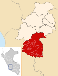
 The district of San Isidro is located in the southwest of the province of Huaytará (marked in red) |
|
| Basic data | |
| Country | Peru |
| region | Huancavelica |
| province | Huaytará |
| Seat | San Isidro de Huirpacancha |
| surface | 169 km² |
| Residents | 1108 (2017) |
| density | 6.6 inhabitants per km² |
| founding | July 25, 1955 |
| ISO 3166-2 | PE-HUV |
| politics | |
| Alcalde District | Hernan Gustavo Espino Huamani (2019-2022) |
Coordinates: 13 ° 57 ′ S , 75 ° 14 ′ W
The district of San Isidro is located in the province of Huaytará in the region of Huancavelica in south- central Peru . The district was established on July 25, 1955. It has an area of 169 km². The 2017 census counted 1108 residents. In 1993 the population was 969, in 2007 it was 1,114. The district administration is based in the 3642 m high village of San Isidro de Huirpacancha with 365 inhabitants (as of 2017). San Isidro de Huirpacancha is 41 km south-southeast of the provincial capital Huaytará .
Geographical location
The district of San Isidro is located in the Peruvian Western Cordillera in the southwest of the Huaytará province. The Río Grande flows along the southeastern district boundary to the southwest and drains the area.
The district of San Isidro borders in the southwest with the district Yauca del Rosario ( province Ica ), in the northwest and in the north with the district Santiago de Chocorvos , in the northeast with the district Laramarca and in the southeast with the district Córdova .
Web links
- Peru: Huancavelica region (provinces and districts) at www.citypopulation.de
- INEI Perú