Yauca del Rosario district
| Yauca del Rosario district | |
|---|---|
 The district of Yauca del Rosario is located in the north-east of the province of Ica (marked in red) |
|
| Basic data | |
| Country | Peru |
| region | Ica |
| province | Ica |
| Seat | Pampahuasi |
| surface | 1263 km² |
| Residents | 1202 (2017) |
| density | 1 inhabitant per km² |
| founding | June 25, 1855 |
| ISO 3166-2 | PE-ICA |
| politics | |
| Alcalde District | Nilton Mario Peves Esquivel (2019-2022) |
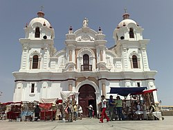
| Iglesia de la Virgen del Rosario de Yauca | |
Coordinates: 14 ° 6 ′ S , 75 ° 29 ′ W
The district of Yauca del Rosario is located in the province of Ica in the region of Ica in southwest Peru . The district was founded on June 25, 1855. It has an area of 1263 km². The 2017 census counted 1,202 inhabitants. In 1993 the population was 1331, in 2007 1117. The district administration is located in the 825 m high village of Pampahuasi . Pampahuasi is located 27 km east of the regional and provincial capital of Ica .
Almost 20 km east-southeast of Ica is the Iglesia de la Virgen del Rosario de Yauca ( ⊙ ) church, built between 1947 and 1951 in the district .
Geographical location
The district of Yauca del Rosario is located in the north-east of the province of Ica. It extends over the foothills of the Peruvian Western Cordillera as well as the desert-like plain to the west.
The district of Yauca del Rosario borders in the south with the district Santiago , in the west with the districts Pachacutec , Pueblo Nuevo , Los Aquijes and La Tinguiña , in the northwest with the district San José de los Molinos , in the northeast with the districts Santiago de Chocorvos , San Isidro and Córdova (all three in the province of Huaytará ) and in the east to the district of Tibillo ( province of Palpa ).
![]() Map with all coordinates: OSM | WikiMap
Map with all coordinates: OSM | WikiMap
Web links
- Peru: Region Ica (provinces and districts) at www.citypopulation.de
- La Virgen del Rosario de Yauca - Ica - El Perú necesita de Fátima at www.fatima.org.pe
