Huaytará district
| Huaytará district | |
|---|---|
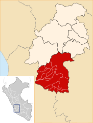
 The district of Huaytará is located in the west of the province of Huaytará (marked in red) |
|
| Basic data | |
| Country | Peru |
| region | Huancavelica |
| province | Huaytará |
| Seat | Huaytará |
| surface | 401.3 km² |
| Residents | 2146 (2017) |
| density | 5.3 inhabitants per km² |
| ISO 3166-2 | PE-HUV |
| Website | www.munihuaytara.gob.pe (Spanish) |
| politics | |
| Alcalde Provincial | Ricardo Yauricasa Flores (2019-2022) |
| Church in Huaytará | |
Coordinates: 13 ° 36 ′ S , 75 ° 21 ′ W
The Huaytará District is located in the Huaytará Province of the Huancavelica Region in southwest-central Peru . The district has an area of 401.25 km². At the 2017 census, 2146 people lived in the district. In 1993, the population was 2,307, in 2007 at the 2249th seat of the district administration is the 2658 m provincial high-altitude Huaytará with 1,157 inhabitants (2017).
Geographical location
The Huaytará district is located on the western flank of the Western Peruvian Cordillera in the west of the Huaytará province. The Río Huaytará, a left tributary of the Río Pisco , drains the northern district to the west, the Río Tambillos, a right tributary of the Río Ica , drains the southern part of the district to the southwest.
The district of Huaytará borders in the southwest on the districts of Santiago de Chocovors and San José de los Molinos ( province of Ica ), in the west on the district of Huancano ( province of Pisco ), in the north on the districts of Quito-Arma , Huayacundo Arma and San Antonio de Cusicancha and in the east to the districts of Tambo and Ayaví .
Individual evidence
- ↑ a b Peru: Huancavelica - Provinces & Districts . www.citypopulation.de. Retrieved March 13, 2020.
