Tinta district
| Tinta district | |
|---|---|
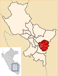
 The district of Tinta is located in the west of the province of Canchis (marked in red) |
|
| Basic data | |
| Country | Peru |
| region | Cusco |
| province | Canchis |
| Seat | Tinta |
| surface | 82.6 km² |
| Residents | 5029 (2017) |
| density | 61 inhabitants per km² |
| ISO 3166-2 | PE-CUS |
| Website | munitinta.gob.pe (Spanish) |
| politics | |
| Alcalde District | León Huancachoque Quispe (2019-2022) |
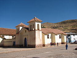
| Church in Tinta | |
Coordinates: 14 ° 8 ′ 42 ″ S , 71 ° 24 ′ 26 ″ W
The Tinta district is located in the Canchis Province of the Cusco region in south-central Peru . The district has an area of 82.6 km². At the 2017 census, 5029 inhabitants lived in the district. In 1993 the population was 5759, in 2007 it was 5528. The district administration is located in the small town of Tinta at an altitude of 3484 m with 2726 inhabitants (as of 2017). Tinta is located on the Río Vilcanota , the upper reaches of the Río Urubamba , 24 km northwest of the provincial capital Sicuani .
Geographical location
The district of Tinta is located in the Andean highlands in the west of the province of Canchis. The Río Vilcanota crosses the district in a north-northwest direction. The national road 3S from Cusco to Puno runs through the district.
The district of Tinta borders in the southwest with the district Yanaoca ( province Canas ), in the west with the district Pampamarca (also in the province Canas), in the north with the district Combapata , in the east with the district San Pedro and in the extreme southeast with the district San Pablo .
Individual evidence
- ↑ a b Peru: Cusco Region - Provinces & Districts . www.citypopulation.de. Retrieved May 11, 2020.
