
Holsterhausen (Dorsten)
|
Holsterhausen
City of Dorsten
|
||
|---|---|---|
_COA.svg) |
||
| Height : | approx. 35 m above sea level NN | |
| Residents : | 13,716 (Dec. 31, 2017) | |
| Incorporation : | April 1, 1943 | |
| Postal code : | 46284 | |
| Area code : | 02362 | |
Location of Holsterhausen in North Rhine-Westphalia |
||
 View over Holsterhausen
|
||

Holsterhausen in the northern Ruhr area is the second largest district of Dorsten in the North Rhine-Westphalian district of Recklinghausen and had 13,716 inhabitants as of December 31, 2017. Since 1929, the former community belonged to the Hervest-Dorsten office . On April 1, 1943, Holsterhausen was incorporated into Dorsten.
Location and events
Holsterhausen is located northwest of the core town of Dorsten, north of the Wesel-Datteln Canal and the Lippe . The village borders the Hohe Mark-Westmünsterland Nature Park to the north and west . The Hammbach flows on the eastern edge of the village .
The central point of the district is Borkener Strasse and Freiheitsstrasse, where most of the shops are located.
Since the former Baldur colliery is located in Holsterhausen , the district is largely characterized by old colliery settlements, such as B. the Baldur colony around Friedensplatz on Luisenstraße, the Göttler-Siedlung (Akazienstraße, Idastraße, An den Birken) and the Blumensiedlung (Lilienstraße, Asternstraße, Nelkenstraße), to name just a few of the many.
In addition to the many simpler residential areas, predominantly characterized by colliery buildings, there are also some bourgeois residential areas characterized by one to two-family houses in Holsterhausen, especially with the new housing estates that have arisen on the western edge of the town.
Worth seeing
Blue lake
The circuit around the Blue Lake is often used as an excursion option. The reservoir holds around 280,000 cubic meters of water and was originally a sand pit into which the groundwater seeped and filled the open-cast mine, which meant that the lake could be used as a bathing lake until the opening of the outdoor pool in 1962. At the moment the lake on the eastern edge of the district is used as a service water storage facility for the Rheinisch-Westfälische Wasserwerkgesellschaft , and bathing is now prohibited.
outdoor pool
The Holsterhausen outdoor pool was opened in 1962 and turned out to be an attraction at the time. With daily prices of one D-Mark, the operators always recorded good visitor numbers. It had three swimming pools: to the left of the entrance area, the round baby pool, a non-swimmer pool with a slide and a sports pool with a diving tower. The roughly 18,000 square meter sunbathing lawn also invited non-swimmers to relax. In 2001, however, the last swimmer visited the pool. In the same year, the bathroom was demolished and the new building followed. According to the mayor, the pool should be reopened in 2002, but since the money provided was used for the operating costs of the Atlantis pool, which was newly built at the same time, the construction of the outdoor pool was stopped. The construction of a new outdoor pool was subsequently refrained from.
movie theater
Another attraction is the Central Kinocenter, the only cinema in Dorsten.
Holsterhausen-Dorf volunteer fire department
The fire brigade of the volunteer fire brigade consists of a command vehicle, a fire engine and a tank fire engine.
Buildings worth seeing

Old Antonius Church
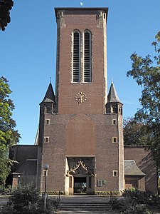
New Antonius Church from 1912/13

Former Boniface School


_01.JPG)
Roman camp
The Roman camps in Holsterhausen contain up to ten marching camps from the time between 11 BC. And 9 (16?) AD, located in the south and southwest of the town center in close proximity to the Lippe. The “Great Marching Camp” of Drusus with an area of 56/57 hectares offered space for two Roman legions plus auxiliary troops, that is up to 12,000 soldiers. It was excavated in 1952 by the Westphalian archaeologist Wilhelm Winkelmann . It served the approach and construction of a bridge over the Lippe for the campaign of the year 11 BC. BC, with which the subjugation of the Sugamberer began. In the period from 1999 to 2001, extensive archaeological excavations were carried out by W. Ebel-Zepezauer, 500 m to the west, during which up to seven other camps of different sizes were discovered. They served as a pioneer camp for various detachments, among other things to make the Lippe navigable. The waterway between Vetera and Holsterhausen was shortened by approx. 25% by straightening. Augustan gold coins were found in the Holsterhauser Feld around 1930. Germanic settlement followed the Roman occupation from the end of the first century. In a Germanic urn cemetery of the 3rd century, a Roman pedestal made of terra sigillata was used for burial.
traffic
The federal motorway 31 runs on the western outskirts of Holsterhausen . There is a motorway parking lot at the level of the district , which also serves as a restricted junction. Otherwise there is the Schermbeck junction in the north and the Dorsten-West junction in the south . Federal road 224 , which is designated as Borkener Strasse , runs through Holsterhausen . To the north of the district, it crosses Bundesstraße 58 . In addition, the L 607 leads to Schermbeck and the K 7 to Rhade .
Bus routes operated by Vestische Straßenbahnen GmbH:
- 216 Dorsten - Hervest - Holsterhausen TaxiBus: Holsterhausen Mitte-Kreskenhof
- 276 Dorsten Friedensplatz - ZOB Dorsten - Gahlener Straße and back
- 278 Dorsten In der Miere - ZOB Dorsten - Wennemarstr and back
- SB 28 Schermbeck Rathaus - Dorsten ZOB - Gelsenkirchen Buer Rathaus and back
Personalities
- Bernhard Delsing , painter
literature
- Wilhelm Winkelmann: In the footsteps of the Romans in Westphalia (1953). In: Contributions to the early history of Westphalia, Münster 1990, pp. 24–29.
- Wolfgang Ebel-Zepezauer among others: Augustan marching camps and settlements of the 1st – 9th centuries Century in Dorsten-Holsterhausen. The excavations 1999–2002. Soil antiquities of Westphalia. Vol. 47, Mainz 2009.
- Franz Schuknecht: The strategic use of the Roman camp in Dorsten-Holsterhausen. Vestische Zeitschrift Vol. 103, 2010/11, pp. 5–23.
Web links
- Information on the Holsterhausen district
- Private website about Holsterhausen
- Holsterhausen in the Westphalia cultural atlas
Individual evidence
- ^ Population Dorsten 2017. Retrieved on May 9, 2019 .
- ^ Population Dorsten 2017. Retrieved on May 9, 2019 .
- ↑ Stephanie Reekers: The regional development of the districts and communities of Westphalia 1817-1967 . Aschendorff, Münster Westfalen 1977, ISBN 3-402-05875-8 , p. 248 .