Drakensberg
| Drakensberg | ||
|---|---|---|
|
Drakensberg |
||
| Highest peak | Thabana Ntlenyana ( 3482 m ) | |
| location | South Africa , Lesotho | |
|
|
||
| Coordinates | 29 ° S , 29 ° E | |
| rock | predominantly basaltoids | |
| particularities | highest mountain range in southern Africa | |
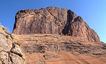
The high up to 3482 meters Drakensberg ( German literally means "dragon mountain" ; Afrikaans Drakensberg ; English Drakensberg ) are the highest mountains of southern Africa . In Lesotho , where the highest elevation of the Drakensberg lies, they are called Maloti . They consist largely of basalt-like rocks.
The Zulu call the Drakensberg uKhahlamba (German: "Wall of the erected spears") because of the numerous gorges, ridges, caves, overhangs and battlements . Because of the clear mountain air far away from civilization, the numerous waterfalls, wildflowers, bird life and the many high, diverse mountains, they are a popular tourist destination . In 2000, the Ukhahlamba-Drakensberg Park , part of the mountain range, was placed on the UNESCO World Heritage List , which was expanded to become the Maloti-Drakensberg Park in 2013 .
location
The high mountain range forms the eastern end of the South African inland highlands and at the same time the natural border between KwaZulu-Natal and Lesotho. From northeastern Mpumalanga on the Panorama Route to the Eastern Cape Province , it stretches for about 1000 kilometers in a north-south direction.
term
The term Drakensberg is generally understood to mean the elongated elevations with numerous gorges in the border area between Lesotho and the South African province of KwaZulu-Natal. There is also another stepped rocky landscape in the provinces of Limpopo and Mpumalanga (formerly Transvaal) that bears the same name. Both landscapes are part of the Great Escarpment ( Great Escarpment ) of South Africa. The following terms are sometimes used to distinguish between the two areas:
- Natal-Drakensberg (English: Natal Drakensberg or KwaZulu-Natal Drakensberg or uKhlahlamba-Drakensberg Mountains )
- Transvaal Drakensberg (English: Transvaal Drakensberg )
The markedly rugged areas of the Great Edge Step between the two main regions that bear their name are also known as the Drakensberg Escarpment .
Emergence
The Drakensberg was formed in the Jura around 180 million years ago by volcanism , which was widespread in the southern hemisphere at that time. Existing thick layers of sediment in the Karoo main basin were flooded by basaltic masses, which today are marked by high mountains and rugged rocky situations. Occasionally, sediment bands from the older layers still occur within the Drakensberg massif. Later erosion deepened the valleys and created debris deposits. The adjacent parts of Kwazulu-Natal were also affected by this volcanism. Here, the tectonic activities created additional uplifts in the sandstone layers, which represent the foothills of the Drakensberg.
Due to the water currents, debris was deposited on the inside of the edge thresholds and large amounts of basalt were removed from the outside.
Classification
Northern KwaZulu-Natal Drakensberg
The northern part includes the spectacular amphitheater , an eight kilometer long, almost vertical rock wall that is 1000 meters high.
In the Royal Natal National Park , there are several hiking trails. This includes the hiking trail into the Tugela Gorge (gorge of the Tugela River with waterfalls) and the path to the highest peak of the north plateau, the 3282 meter high Mont-Aux-Sources .
Central KwaZulu-Natal-Drakensberg
This section is well developed with hiking trails and hotels. Mountains such as the striking Cathkin Peak (3181 m; isiZulu : Mdedelelo , German: Give him space ), Monk's Cowl (3234 m), the Champagne Castle (3377 m), Thabana Ntlenyana in Lesotho (3482 m; highest peak of the Drakensberg) and Giant's Castle .
Southern KwaZulu-Natal Drakensberg
The southern part is less developed for tourism. There are nature reserves here with animals that have become rare.
This is also where the Sani Pass is located , at 2874 meters the highest mountain pass in South Africa and also the only road connection from KwaZulu-Natal to Lesotho, although from the South African border post it is only accessible for all-wheel drive vehicles. Because of its view it is also interesting for tourists.
At the southern end on the Lesothic side of the border lies the Sehlabathebe National Park , which is also joined by the Tenahead Mountain Reserve .
Highlands in Lesotho
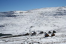
The Highlands or Maloti Mountains cover about three quarters of the area of Lesotho. It is predominantly an earlier high plateau over 3000 meters high, which has received its present form through deeply cut river valleys. In the north-west of the mountains lies the 3100-meter-high Front Range , which is bounded to the east by the Malibamatšo , a tributary of the Senqu or Oranje. In the southwest the Thaba Putsoa Range rises up to the 3096 meter high Thaba Putsoa ("Blue Mountain"). These two mountain ranges are separated from the Central Range by the Senqunyane , which in turn is delimited to the east by the Senqu from the plateau-like part of the mountain range that makes up the greater part of the Mokhotlong district . There is also the Tlaeeng Pass , the highest road pass in Africa at 3,275 meters above sea level. The highest settlement at around 3,100 meters is Letšeng-la-Terae, which was built near a diamond mine - which in turn is the highest of its kind in the world. The buildings of the Lesotho Highlands Water Project , which supplies the arid South African province of Gauteng with water, are also located in the Maloti Mountains .
Rock art
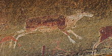
The Drakensberg are also known for the numerous rock carvings by the San . In almost every cave and under almost every rock overhang there are depictions of people and animals, of hunting, dance and rituals. It is assumed that there are around 600 sites with a total of 35,000 individual representations in the area of the national park. Not only is the large number of pictures unusual, but also the fact that they can all be attributed to a single artistic tradition, namely the culture of the San.
There are also San rock paintings in Lesotho, but they are mostly difficult to access in the Drakensberg area.
Others
The 2012 film ends with the fact that after the end of the world due to the elevation of the African plate, the Drakensberg now represent the highest elevation on earth.
See also
Web links
- Entry on the UNESCO World Heritage Center website ( English and French ).
- Liphofung Cave and Cultural Historical Site ( Memento from July 22, 2011 in the Internet Archive )
- Geological description with profile ( Memento from July 2, 2013 in the Internet Archive ) (English; archive version)
Individual evidence
- ↑ Description on the UNESCO website , accessed on February 5, 2014 (English)
- ^ AW Rogers, AL Hall, PA Wagner, SH Haughton: The Union of South Africa. Handbook of Regional Geology. VII. Vol. Abt. 7a, Heidelberg 1929. pp. 4-5
- ^ About South Africa. The country. Relief. on www.ufh.ac.za ( Memento from October 6, 2014 in the Internet Archive )
- ^ Map of Lesotho. 1: 250,000. Lesotho Government, 1978
- ↑ David Ambrose : The Guide to Lesotho. Winchester Press, Johannesburg / Maseru 1976, ISBN 0-620-02190-X , p. 199.
- ↑ Portrait of the diamond mine , accessed on August 9, 2014 (English)


