
Duisburg city forest
The Duisburg City Forest is a forest area of around 600 hectares in Duisburg .

Location and botany
The Duisburg city forest is located about 3.5 km east of Duisburg city center on the city limits of Mülheim an der Ruhr in the Duisburg districts of Duissern and Neudorf . It extends from the A 40 in the north to the Bissingheim district in the south. The entire area is accessible by marked hiking trails. In the north, the main road between Duisburg and Mülheim crosses the forest. Here - on part of the Kaiserberg - is also the Duisburg Zoo . In the southern part the Uhlenhorststraße leads through the city forest. The western border is the A3 .
The Broich-Speldorfer Wald adjoins the Mülheim urban area to the south-east . Together with this forest area, the Huckinger Mark and the Grindsmark in the south of Duisburg, there is an approximately 30 km² contiguous forest area between the cities of Duisburg and Mülheim. The Ruhrhöhenweg and the Neandertalweg of the Sauerland Mountain Association lead through the forest .
The largest part of the urban forest goes back to the beech as the dominant tree species.
The highest point is about 80 m above sea level. NHN near Wolfsburg , a former restaurant that is now used as a church meeting place.
In addition to oaks and beeches, there are larger occurrences of holly ( Ilex ). In the near-natural area, different trees have been planted over the years. However, alder and birch trees are the main ones on the streams .
Part of the forest area, now ten percent, is left to its own devices without human intervention, in accordance with the criteria of the Forest Stewardship Council (FSC).
leisure
There is an educational forest trail in the city forest. In the area of the Kammerweg, boards explain the tree species that have been specially planted for the tree of the year . A meadow orchard created by a school class conveys the flora and fauna of this biotope . The five sculptures by Duisburg sculptor Regina Bartholme, which can be found here and there along the way, convey the urban forest as an “art space”. The sculpture path includes the chamber path, circular path, mountain and valley path and owl path. There are signposted circular courses for sporting activities such as running and walking , and some paths are marked as cycle or bridle paths.
In the vicinity of the forester's house there is a 10,000 square meter wild boar enclosure with around 22 wild boars.
history
The underground of the city forest consists of Septarian clay from the Tertiary , on which about 20 m high Rhine gravel from the first ice age and ground moraine from the second ice age are deposited.
The Duisburg city forest and with it the other forests between Duisburg, Kettwig , Ratingen and Düsseldorf are the remnants of a huge imperial forest bordered by the Rhine , Ruhr and Düssel . In 1065, King Heinrich IV gave the forest, together with the Duisburg Imperial Court, to Archbishop Adalbert of Bremen . The privilege to use the forest was - after the overthrow of the archbishop and after the area was again administered by the Reichswald and administered by the Dukes of Limburg - to the Dukes of Berg in the 14th century.
The Duisburg Forest was of the greatest economic importance in the Middle Ages. It belonged to the city and was only available to a limited number of citizens. These citizens were called forest heirs. In the Bergisch area (see also the Duchy of Kleve ) the use of the forest was only possible for the owners of a cooperative share. However, the poor population was allowed to collect reading wood and leaves. They were also allowed to drive the pigs to be fattened in the forest for a fee. As a forester, the Duke von Berg ran a wild horse .
Due to the development of settlements and the use as arable land , building land , construction and firewood and livestock farming, the forest area was pushed back further and further. The industrialization further reduced the forest cover.
The old quarry is located north of the Uhlenhorststraße crossing the forest in the direction of Mülheim. A small lake has emerged in the fenced-in pit with steep edges in places. The area is completely covered with vegetation; the graywacke sandstone that emerges is only rarely visible. The stones that were broken here in the Middle Ages were used to build the city wall and occasionally also for residential buildings. 1129 confirmed King Lothar III. the right of Duisburg citizens to read stones in the city forest for free. In the middle of the 19th century, stones were systematically broken on Steinbruchweg. The quarry has been closed since 1874.
In the city forest there are also several tunnels in which the Duisburg city council had coal digged but never found anything. The oldest tunnel dates from 1562. The "Schinderhanneshöhle" can still be seen today.
Soil monuments
On the Finkenpfad there are remains of settlements from the younger Bronze Age and older Iron Age in the area of the “Heiliger Brunnen” spring.
The Holy Well is located directly at the intersection of Rundweg and Kammerweg. The heights of the Duisburg city forest consist in the uppermost layers of gravel and sand, which filter and store the rainwater. On the water-impermeable tertiary clays below, which run diagonally, the water flows off and emerges as a spring on the slopes, as here at the Holy Well. Mentioned for the first time in 1563 as the Marienquelle "hillgen Bornschen Berg", the water is minerally and medicinally worthless as it does not come from the depths. Around 1935, the source and the surrounding area, which was presumably a place of worship in prehistoric times, were set in quarry stone. The miraculous healing power of water, especially at the time of the plague, is just a legend.
The quarry with its heaps, paths and walls has been one of the soil monuments since 1990.
Photo gallery

The Expo bridge on the motorway along the city forest

Sculpture “White Puppets” by Regina Bartholme in the Duisburg city forest
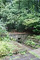
"Holy Well" in the Duisburg city forest

In the nightingale valley
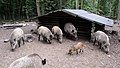
Wild boar enclosure at the forester's house


See also
Web links
Individual evidence
- ↑ See the signs on the Nachtigallental-Weg.
- ↑ Kathrin Hänig: Corona time out: There are newcomers in the Duisburg city forest. Westdeutsche Allgemeine Zeitung , April 23, 2020, accessed on June 28, 2020 .
- ↑ "Duisburg Walks", 1963, Carl Lange Verlag, Duisburg, page 7
- ↑ Walter Kordt : The wild horses in the Angermunder Forest - When the forest between Düsseldorf and Duisburg was still under wilderness - , in: Bürgererverein Duisburg-Huckingen e. V. (Ed.): Huckinger Heimatbuch, Geschichte und Geschichte , Volume II, Duisburg 1997, pp. 52–57.
- ↑ Land monument list no.4b (PDF): ( page no longer available , search in web archives ) Info: The link was automatically marked as defective. Please check the link according to the instructions and then remove this notice. Settlement remains from the younger Bronze Age and the older Iron Age, from www.duisburg.de
- ↑ Information board of the city of Duisburg at the Holy Fountain
Coordinates: 51 ° 25 ′ 22 " N , 6 ° 48 ′ 38" E