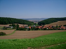
Ellierode (Bad Gandersheim)
|
Ellierode
City of Bad Gandersheim
Coordinates: 51 ° 50 ′ 14 " N , 10 ° 3 ′ 23" E
|
||
|---|---|---|
| Height : | 228 m | |
| Residents : | 166 (Apr 2010) | |
| Incorporation : | March 1, 1974 | |
| Postal code : | 37581 | |
| Area code : | 05382 | |
|
Location of Ellierode in Lower Saxony |
||
|
Ellierode
|
||
The village of Ellierode is a district of Bad Gandersheim in the Northeim district in Lower Saxony ( Germany ). It is located on the edge of the Harz between the Abbess Mountain and the Kühler, about 6 km southeast of the town center of Bad Gandersheim.
history
In 1007 the small town of Ellierode was created in the protected Alvungamark valley . At that time still under the name Alveningarod . The mansions and servants' houses in the second row were built around today's St. Stephen's Church . A predominantly religious village community developed under the protection of the Bad Gandersheim virgin monastery.
Ellierode was nicknamed "The Hidden Village" towards the end of the Second World War . When the American troops marched into Bad Gandersheim in the spring of 1945, Ellierode remained undiscovered for two weeks due to its valley location in the middle of forests. It wasn't until an airplane landed on the radiator that the Americans became aware of the village. There were two German fighters.
On March 1, 1974 Ellierode was incorporated into the city of Bad Gandersheim.
Infrastructure
In 1875 the volunteer fire brigade was founded in Ellierode . To date it has over 25 active members and around 60 sponsors. The fire brigade as the central association is the host for many celebrations in Ellierode.
Of around 170 permanent residents, more than 20 are children and young people. There is a playground for the children in the shelter of old walnut trees. The older children can play on the football field .
politics
Heidi Beitz is the mayor of Ellierode.
literature
- Kurt Kronenberg : Ellierode. The hidden village. Timeline. = Chronicle of Ellierode (= local church art and church history. H. 3, ZDB -ID 1014603-9 ). Regional Church Office of the Braunschweig Evangelical Lutheran Church, Wolfenbüttel 1963.
Individual evidence
- ^ Federal Statistical Office (ed.): Historical municipality directory for the Federal Republic of Germany. Name, border and key number changes in municipalities, counties and administrative districts from May 27, 1970 to December 31, 1982 . W. Kohlhammer GmbH, Stuttgart and Mainz 1983, ISBN 3-17-003263-1 , p. 269 .

