Encinitas
| Encinitas | |
|---|---|
 |
|
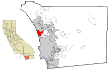
| Encinitas' location in San Diego County | |
| Basic data | |
| Foundation : | 1986 |
| State : | United States |
| State : | California |
| County : | San Diego County |
| Coordinates : | 33 ° 3 ′ N , 117 ° 16 ′ W |
| Time zone : | Pacific ( UTC − 8 / −7 ) |
| Residents : | 62,000 (as of 2006) |
| Population density : | 1,252.5 inhabitants per km 2 |
| Area : | 52.1 km 2 (approx. 20 mi 2 ) of which 49.5 km 2 (approx. 19 mi 2 ) are land |
| Height : | 25 m |
| Postcodes : | 92023, 92024 |
| Area code : | +1 760 |
| FIPS : | 06-22678 |
| GNIS ID : | 1652705 |
| Website : | www.ci.encinitas.ca.us |
| Mayor : | Jerome Stocks |
Encinitas is a city in San Diego County in the US state of California , United States , with 60,900 inhabitants (as of 2004).
Encinitas is considered one of the best surfing spots in the world for surfing .
geography
The metropolitan area has a size of 52.1 km² and is located on Interstate 5 .
Encinitas is located a few miles north of San Diego and 150 km south of Los Angeles .
climate
The climate in Encinitas is very mild. The average maximum daily temperature is 22 ° C.
Demographics
In 2010 the population density was 1149.6 inhabitants per km².
economy
The city's strongest industry is the plant industry. Encinitas is the seat of the horticultural company Paul Ecke Ranch .
Age groups
Table with percentage of inhabitants per age group
| under 18 | 18 to 24 | 25 to 44 | 45 to 64 | over 65 |
|---|---|---|---|---|
| 20.6% | 6.3% | 27.9% | 32.3% | 12.8% |
Average age: 41.5 years
Personalities
Sons and daughters
- Chase Budinger (* 1988), basketball player
- Sian Welch (* 1966), triathlete
- Emily Ratajkowski (* 1991), model, grew up here
Residents
- Jerry Buss (1933–2013), owner of the Los Angeles Lakers
- Tom DeLonge (* 1975), guitarist and singer with Blink-182 and Angels & Airwaves
- Chad Butler (1973–2007), Switchfoot drummer
- Jon Foreman , singer and guitarist for Switchfoot
- Tim Foreman , Switchfoot bassist
- Cindy Lee Berryhill , singer & songwriter
- Scott Stephens , singer with Liquid Blue
- Jack Tempchin , musician and songwriter
- Shaun White (* 1986), snowboarder and skateboarder
- Jeff King , skateboarder
- Mason Aguirre , snowboarder
- Richard Dreyfuss (* 1947), actor
- Robert Foxworth (born 1941), actor
- Rob Machado , surfer
- Jeremy McGrath , supercross driver
- Jack McDowell , baseball player and musician
- Paula Newby-Fraser (* 1962), triathlete
- Hiromi Itō (* 1955), writer
- Kenny Souza (born 1964), duathlete
- Yogananda (1893–1952), Indian yoga master
- Merrick Hanna , robot dancer
Web links
Commons : Encinitas - collection of images, videos and audio files
