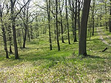
Ernstbrunner Wald (forest area)
Coordinates: 48 ° 34 ' N , 16 ° 17' E
The Ernstbrunn Forest - also Kirchenwald , Porrauer Wald , Glasweiner Wald or Hollabrunner Wald - is a mixed oak forest area over gravel and sands of the Urdonau between Hollabrunn and Ernstbrunn in the Weinviertel in Lower Austria. It is the largest closed mixed oak forest area in Central Europe.
Location and surroundings


The forest area is located about 35 kilometers north of Vienna. It is the only larger closed forest area in the Weinviertel, the “green lung of the Weinviertel”, and an important local recreation area.
This room bears its current name as the umbrella term for the area that is predominantly in the area of the greater Hollabrunn community. The name of the geologists who speak of the Hollabrunn-Mistelbach Formation (HMF) also gives it its name. Sub-areas have the following names: Kirchenwald, Raschalaer Wald, Black Forest, Glasweiner Wald, Göllersdorfer Wald, Guntersdorfer Hauswald , Hollabrunner Wald, etc. The name "Ernstbrunner Wald" has become common among ornithologists, whereby on the official Austrian map 1: 50,000 the latter only in eastern section appears.
The area is divided into the districts Hollabrunn , Korneuburg and Mistelbach , mostly surrounded by fields. The different names are all local names in the communities that have a share in the forest area.
geology

The then much further north flowing ancient Danube outsourced during Pannoniums between the output of the Wachau on Hohenwarth , Ziersdorf , Hollabrunn and further north the Leiser Berge on the Waschberg zone along the Zaya -Furche to the quarry mountain in the Vienna Basin sand and gravel up to 50 meters Thickness from. Since these fluvatic deposits of the former channel filling are more resistant than the surrounding sediments of the molasse zone , they withstood the erosion better over time and are now preserved as ridges ( relief reversal ). Since this ridge of the Hollabrunn-Mistelbach Formation, consisting partly of basic limestones , partly of acid quartz and acid crystalline rocks , formed difficult-to-manage and poorly productive soils, it was not used for arable farming, which is why it is still largely covered with forest today.
Flora and fauna
|
The animal world has special features to offer:
|
The following rare plants (some of which are already considered endangered according to the red list) are found here, among others:
|
- a beech with a particularly large circumference (picture on the right)
Wildlife corridor
According to a study by the University of Natural Resources and Life Sciences (1999, 2005, 2009) there is a wild animal corridor through the Hollabrunn Forest / Ernstbrunn Forest in the municipality of Göllersdorf .
tourism
- Koliskowarte: The originally 12 meter high lookout tower on the 332 m high Geißberg near Hollabrunn was built from granite rubble stones in 1935, on behalf of and at his own expense by the former mayor Rudolf Kolisko under the direction of master builder Neumeister. The usage consensus was given on August 29, 1935 by the Raschala community. As the view of Hollabrunn was only possible to a limited extent due to the growth of trees, the control room was raised to double the height in 2016 with a metal construction and also provided with a climbing device. The now 24-meter-high observation tower is freely accessible and again offers a clear panoramic view of the trees. It can be reached from the outskirts of Magersdorf with a walk of approx. 700 meters.
- Buschberghütte near Ernstbrunn: It is 480 m above sea level. A. the lowest hut of the Austrian Alpine Club .
Web links
Individual evidence
- ↑ a b The Austrian card OK200 uses Ernstbrunner W. as a general name
- ↑ Kirchenwald , hollabrunn.gv.at
- ^ Godfrid Wessely : Geology of the Austrian Federal States, Lower Austria , Vienna 2006, ISBN 3-85316-239-8
- ^ Friends of the Hollabrunn forest: Studies on the Hollabrunn forest . Self-published, February 2013, p. 23 f .
- ^ Friends of the Hollabrunn Forest. Lebensministerium.at, accessed on June 2, 2013 .
-
↑ II = animal and plant species of community interest, for the conservation of which special protected areas must be designated.
IV = Animal and plant species of community interest to be strictly protected. - ↑ Wildcat sightings. Thayatal National Park, accessed on June 2, 2013 .
- ↑ Golden eagle. Club 300 Austria, accessed on May 31, 2013 .
- ↑ Stefan Lefnaer: Floristic news from the Lower Austrian Weinviertel and Vienna north of the Danube . - Neilreichia 9 (2018): 133-142. [1]
- ↑ Office of Dr. Paula ZT GmbH: Marktgemeinde Göllersdorf Local spatial planning program. Draft. March 2013, p. 56 , archived from the original on December 9, 2014 ; accessed on July 30, 2017 .
- ↑ New Koliskowarte opens up a view to Schneeberg and Ötscher at hollabrunn-tourismus.at


