Princely Park Inzigkofen
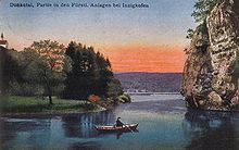
The Princely Park Inzigkofen , also called Princely Plants Inzigkofen , is a landscape garden from the Romantic period with culturally and historically significant garden architecture . The park was created between 1811 and 1829 in what is now the Baden-Württemberg municipality of Inzigkofen , west of the Hohenzollern district town of Sigmaringen , on both sides of the Danube . This was caused by Princess Amalie Zephyrine , who was also known as the “Princess of Paris” and “Savior of the House of Hohenzollern”. The 25 hectare park area is owned by the Princely House of Hohenzollern and has been looked after for years on a voluntary basis by the members of the Inzigkofen local group of the Swabian Alb Association.
Attractions
Amalienfelsen
The 28.6 meters above the water level of the Danube towering cliffs reminiscent of the large iron letters "in memory of Amalie Zephyrine 1841" and the alliance coat of arms of the royal houses Hohenzollern and Salm-Kyrburg to the creator of Inzigkofer Landscape Park, Sigmaringer Princess Amalie Zephyrine (1760 –1841), a née Princess von Salm-Kyrburg, and her husband, Prince Anton Aloys von Hohenzollern-Sigmaringen (1762–1831). The legend is associated with the romantic rocky area that Amalie Zephyrine plunged from here on a gray horse into the floods of the Danube from lovesickness. In fact, she died on October 17, 1841 at the then high age of 81 in the "Schlössle" built for her on Leopoldsplatz Sigmaringen after moving from Inzigkofen.
Panoramic view and avenue of lime trees on the Amalienfelsen
The Amalienfelsen, which rises steeply over the Danube, is joined by a range of hills about two hectares in size, gently sloping to the southeast. Access to this hill is optionally possible via a wide arc, moderately rising walk along the southern slope or through a steep rocky section on the southwest side. Special attractions on the hill are the wonderful panoramic view of the entire front park and the Hermitage from the steep slope edge of the Amalienfelsen high above the Danube and, on the other hand, the elongated avenue of lime trees on the top of the ridge, which gives a precise view of the tower when descending the pilgrimage church of St. Peter and Paul in Laiz . In contrast to the current bushes, the avenue of lime trees was originally completely free, and only the steeper slopes were planted with groups of trees.
Monument to Prince Friedrich III. from Salm-Kyrburg
The simple sandstone monument, erected on a 4.5 meter high Jurassic limestone rock on the eastern edge of the princely grounds, commemorates Princess Amalie Zephyrine's favorite brother, Prince Friedrich III. von Salm-Kyrburg (1745–1794), who was guillotined in Paris on July 23, 1794 during the French Revolution . Amalie Zephyrine remained loyal to him after his death and set up very personal sites of remembrance and mourning, first in Paris and then in the Inzigkofer Park in the 1820s. The monument hill, which is planted with ornamental shrubs and trees and equipped with a bench, offers a view of the church of Laiz and the Sigmaringen Castle . After its departure, the memorial was reconstructed in 1998 according to older descriptions and contemporary witness memories.
Boat landing and Danube jetty
The Danube is the central point of reference for the Inzigkofer plants, which extend on both sides of the river. Marked by a towering ship pillar and benches, there was a ferry connection between the south and north banks of the particularly wide stretch of the river in the 19th century, which, together with the boats often depicted in pictures and photos, offered the special attraction of crossing. In 1940, a pioneer unit of the Wehrmacht, quartered in Inzigkofen, built a wooden footbridge over the Danube, which was widely used by park visitors until it was destroyed by a flood in 1953. To this day, wooden posts in the water of the Danube are a reminder of this lost connection between the two banks of the park.
Suspension bridge
A wooden walkway over the Danube, built in 1940 by a pioneer unit above the Amalienfelsen, was torn away by a flood on June 27, 1953. To replace the connection to the northern part of the park, a Swiss company built a suspension bridge for pedestrians for 665,000 euros. This was inaugurated in March 2019 in the presence of the Prime Minister of Baden-Württemberg Winfried Kretschmann .
Lookout point to rocks and Danube meadows
The ascent from the boat landing along the steep slope on the right side of the Danube to the Devil's Bridge and beyond to the plateau leads over elaborately built and maintained hiking trails with a multitude of steps, through rocky areas secured with railings, over bold staircase constructions as well as paths resting on retaining walls , whereby tufa-lime is used as a building material in earlier times, but nowadays concrete is sometimes used. Again and again there are suddenly wonderful views of the Hermitage, the Danube flowing past deep down, the Nickhof, the meadows and floodplains along the river, the surrounding rock formations in the Danube breakthrough valley. Benches invite you to linger, to rest after the strenuous ascent, to enjoy the varied view.
Devil's bridge
One of the most striking sights in the Princely Complex is the Devil's Bridge, which is 21.5 meters long and crosses a wild and romantic gorge, the 19.5 meter deep “Höll”. The wooden bridge constructed when the park was expanded to the west in 1843 was replaced in 1895 by an elegantly curved concrete structure with ascending and descending stairs. The bridge, the name of which probably goes back to the enthusiasm for Switzerland in Romanticism and is derived from the real Devil's Bridge at the Gotthard Pass , was soon embellished with a legend according to which the builder tried to outsmart the devil, who helped him with the bridge construction, by demanding the "wages" was able to. After passing the bridge, you leave the gorge through a four-meter-long, artificial rock tunnel. The "Höll" below the bridge was accessible in the early days through an adventurous staircase and footbridge, the "Himmelsleiter".
Känzele
A particularly beautiful panoramic view is offered by the “Känzele”, the apex of an imposing rock ledge at a dizzying height above the Danube, which flows lazily through a wide, lovely meadow valley, the Degernau. During floods, especially after the snow melts in spring, the floodplain turns into a lake landscape. The view extends far beyond Degernau to wooded slopes and hills to the ruins of Broken Gutenstein , the conical Tiergärtle planted with beech trees and right on the horizon to the Lenzenfelsen ( 790 m above sea level ) halfway to Beuron . The western orientation of the observation rock secured with railings makes the sunset a special experience and offers a romantic encounter with nature as it was often promoted in the landscape gardens of the 18th and 19th centuries.
Grottoes and rock gate
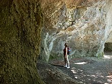
The romantic part of the park includes the Inzigkofer Grottoes , the rock overhangs and a huge rock gate , which the hiker can reach on a stepped path on the steep descent from Känzele. The Nebelhöhle is particularly impressive , a rock grotto more than five meters high and over ten meters deep, which during the use of Inzigkofens as a summer residence by Hereditary Prince Karl Anton and his young family in the 1840s was furnished with tables and wooden benches and along with ancient wooden weapons Rock walls was equipped. At the end of the hunt, the route, the game, was lined up and "blown". The picturesque rock formations are washings of mass limestone that were organically formed from sponge reefs in the tropical and warm White Jurassic Sea about 150 million years ago. The washouts and the entire valley landscape were shaped by the Schmeie, whose bed the Danube took over here after the crack ice age.
Inzigkofen rock roof
During archaeological investigations in the Inzigkofen rock roof below the Nickhof in 1938 by Eduard Peters and in 1965 by Wolfgang Taute , an approximately one meter thick layer of finds was discovered and partially excavated. There were typical Mesolithic (about 8000-5500 v. Chr.) Artifacts such as deer antler harpoons and stone tools ( microliths ). The Neolithic Age (approx. 5500–2000 BC) and the Bronze Age (approx. 2000–800 BC) have been documented through finds of animal bones, remains of fish, antler and stone artefacts. There were even individual bones and teeth of human origin. Thick layers of fire indicate the presence of campfires. The rock roof was not a year-round living space, but a seasonal storage space for hunting and fishing in the Danube Valley.
Meinrad Chapel
A stately foundation is the St. Meinrad Chapel , which stands on the highest point of the Hermitage in the Princely Park . It dates from 1840 and is decorated with a crucifixion group, that is, four paintings made of oil on copper. In 1947 the old chapel was destroyed by fire and rebuilt in 1948. Since that time there has been a commemoration of the Battle of Stalingrad with large commemorations in the 1960s.
literature
- Hartmann Reim: At Amalie Zephyrine's tea house - archaeological excavations in the Princely Park in Inzigkofen, Sigmaringen district. In: Monument Preservation in Baden-Württemberg , 36th year 2007, issue 1, pp. 42–47 ( PDF )
Web links
Individual evidence
- ↑ To Inzigkofer Park . In: Wanderbar ... the most beautiful routes. Experience the Sigmaringen district . District Office Sigmaringen, Druckerei Schönebeck, Meßkirch 2004. pp. 11–13.
- ↑ a b c d e f g h i Information boards Fürstliche Anlagen Inzigkofen from the Fürst von Hohenzollern group of companies , municipality of Inzigkofen , Upper Danube Nature Park and Swabian Alb Association
- ↑ suspension bridge
- ↑ Meinrad Chapel
Coordinates: 48 ° 4 ′ 35.5 " N , 9 ° 10 ′ 43.4" E


