
Fürtlibach
|
Fürtlibach Steinwiesbächli (OL), Dorfbach (UL) |
||
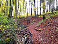
 Fürtlibach after the confluence of the Lochholzbach in Oberengstringen |
||
| Data | ||
| Water code | CH : ZH101746 | |
| location | Switzerland | |
| River system | Rhine | |
| Drain over | Limmat → Aare → Rhine → North Sea | |
| source | at Hönggerberg 47 ° 25 ′ 11 ″ N , 8 ° 28 ′ 59 ″ E |
|
| Source height | 528 m above sea level M. | |
| muzzle | near Oberengstringen in the Limmat coordinates: 47 ° 24 '19 " N , 8 ° 27' 28" E ; CH1903: 676 921 / 251009 47 ° 24 '19 " N , 8 ° 27' 28" O |
|
| Mouth height | 390 m above sea level M. | |
| Height difference | 138 m | |
| Bottom slope | 43 ‰ | |
| length | 3.2 km | |
| Catchment area | approx. 2.3 km² | |
| Left tributaries | Zwüschethölzerenbach | |
| Right tributaries | Weidtobelbach , Lochholzbach | |
| Big cities | Zurich | |
| Communities | Oberengstringen | |
The Fürtlibach (in the upper course Steinwiesbächli , in the lower course Dorfbach ) is a 3.2 km long right tributary of the Limmat . It rises in Zurich's Höngg district , flows through a small ravine after the Rütihof settlement , crosses Oberengstringen and flows a little below this village. The brook drains the western slope of the Hönggerberg and the southeast slope of the Gubrists .
geography


course


The stream rises as Steinwiesbächli in northwest Zurich in the forest area Oberlee northwest of the highest point of the Hönggerberg at 528 m above sea level. M. The source is directly on the Regensdorferstrasse , which connects Regensdorf with Höngg . It initially flows briefly in a south-easterly direction, only to take a south-westerly course shortly afterwards. It is overturned for the first time after around 260 meters . It crosses under Regensdorferstrasse , passes Grünwald and briefly runs under a field. Between the Grünwaldweg and the street Im Stelzenacker there is an approximately 90-meter-long open section through a residential area before it is overturned again.
The stream is now called Fürtlibach and crosses the Rütihof settlement , first under the Rütihofstrasse , then shortly in a northerly direction under the Hauswiesenstrasse . At a small turning loop it is directed to the west and runs briefly under a field before it reaches a forest edge and comes back to the surface. It now flows through an increasingly steep ravine, which is called a hole at the deepest point . At the Hasennest corridor , the edge of the forest spreads into a grove of perforated wood .
After the confluence of the Weidtobelbach from the right, it is called Dorfbach and forms the municipal boundary for around 70 meters before it crosses over to Oberengstringer Boden. Here it also takes the water from three nameless and artificial ponds. Shortly after the confluence of the Lochholzbach from the right, the ravine opens again increasingly, and on its bank there is again a narrow forest edge. It now runs mainly in a south-westerly direction and takes on the Zwüschethölzerenbach from the left. At the settlement boundary of Oberengstringen, shortly before the stream enters the Limmattal , it is overturned again, and that up to its mouth. The stream again crosses Rütihofstrasse and Zürcherstrasse and then briefly follows Dorfstrasse . After this section it passes under the settlements in the village and in the upper Neugut and the A1H motorway feeder . Finally the brook flows into the river opposite Schlieren at 390 m above sea level. M. from the right into the Limmat .
Tributaries
- Weidtobelbach , from the right and north at 453 m above sea level. M. in the hole , 0.36 km long. Rises at the Flur Im hinter Ried at 494 m above sea level. M. , partly forms the municipality boundary and feeds a small pond just before the mouth.
- Unnamed marshy trickle in the hole , which also absorbs the water of the largest of the three ponds. It is very likely that it flows through the former ravine of the Weidtobelbach and is possibly fed by it underground.
- Lochholzbach, from the right and northwest to 444 m above sea level. M. also in the hole , 0.28 km long. Rises at 482 m above sea level. M. at the reservoir in the forest area Lochholz and flows through this up to its mouth.
- Zwüschethölzerenbach (in Zurich Frankenbüelbach , also Bach im Frankenbüel ), from the left and southeast to 422 m above sea level. M. at the settlement of Staldenäcker , 1.1 km long. Rises near Frankental in Höngg at about 458 m above sea level. M. and then runs mainly on the municipality of Oberengstring.
geology
The creek has in quaternary Würm - moraine sediment, consisting of clay, silt and sand, eaten. Alluvion soil is found at the mouth of the Limmat Valley .
Flora and fauna
In the headwaters of the Hönggerberg, the Fürtlibach typical woodruff - beech forest flows through it . The forest area of Lochholz above Oberengstringen is characterized by woodruff beech forest with dogwood , grove and lungwort . On the other hand, around the mouth of the Weidtobelbach, there is a maple - ash forest with bingelkraut .
The smallest of the three ponds in the hole , which is not accessible via paths, offers habitat for the rare common midwife toad . The nature and bird protection association Höngg has been committed to their continued existence for years and supports a species promotion project.
photos

Fürtlibach with a view towards Loch shortly before the confluence of the Weidtobelbach on Zürcher Boden
Fürtlibach im Tobel with an eroded bank wall; View towards Rütihof

The largest of the three ponds in the hole


Web links
- Course of the Fürtlibach on GIS Zurich
swell
Individual evidence
- ↑ a b c d e f g h Individual records of the geographic information system of the Canton of Zurich
- ↑ Own observation
- ↑ Weidtobel with shading in relief. Geoserver of the Swiss Federal Administration
- ↑ In the hole. Website of the Höngg Nature and Bird Conservation Association