Feng (Baoji)
The county Feng ( 鳳縣 / 凤县 , Feng Xiàn ) belongs to the administrative area of the prefecture-level city Baoji in the western Chinese province of Shaanxi . It has an area of 3,187 square kilometers and a population of 110,000 (2019). The 79.8% forest area is located on the southern slope of the Qin-Ling mountain range . Its highest point is the Toumaju (透 马驹 峰) on the border with Gansu at 2739 m , the lowest point at 915 m is in the valley of the Wangyu (旺 峪河) in the southwest of the district. Its main town is the Shuangshipu (双 石 铺镇) community.
history
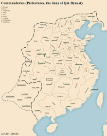
During the Qin Dynasty (221–207 BC) the sparsely populated district, then under the name Gudao (故道 县), belonged to the Longxi (陇西 郡) headquarters on the border with the Qiang tribes. Liu Bang , the founder of the Han Dynasty , divided after coming to power in 207 BC. From the south of the Longxi command center and founded the Guanghan command center (广汉 郡) in today's Sichuan , Gudao County remained with Longxi. Emperor Liu Che founded From the southern part of Longxi and the northern part of Guanghan the Wudu commandant's office (武 都 郡); Guangdao County was assigned to the new headquarters.
At the beginning of the Three Kingdoms (220–280 AD), the area was the scene of fierce fighting between Shu Han and the Wei dynasty . After Zhuge Liang had conquered the Wudu headquarters for Shu (present-day Sichuan) in 229, Gudao County formed the border with Wei to the north. At that time the Di (氐) settled in the area of Wei, a Turkish tribe, whose respective leader had been enfeoffed by Wei with the title “Prince” (王). After Wei conquered Shu in 263 and then Chancellor Sima Yan deposed the last ruler of Wei in 265 and founded the Western Jin Dynasty , Di-chief Yang Maosou (杨茂 搜) went into business for himself in 296 and founded the Wudu headquarters the "Kingdom of Zhouchi" (仇池 国). It was not until 441 that Emperor Tuoba Tao (408–452) recaptured the command of the Northern Wei Dynasty (385–535). As a bulwark against the Di, he founded a fortified garrison town, today's large community of Fengzhou, and moved the seat of the county government there , as was everywhere on the borders of the empire .
After the Jurchen conquered Kaifeng in 1127 and captured the Chinese emperor, Prince Zhao Gou withdrew with the court to the south and proclaimed Hangzhou the new capital. In 1138 the Southern Song Dynasty signed a peace treaty with the Jurchen Jin dynasty , but the latter broke again in 1140. In the 11th month according to the lunar calendar of the 11th year of the government motto Shaoxing, i.e. in December 1141, the Shaoxing Peace (绍兴 和 议) was finally concluded, in which both states agreed the ridge of the Qin Ling mountain range as the border, with one Border post on Dasan Pass on today's State Road 212 from Baoji to Fengzhou. So the Feng County, upgraded to prefecture in 1175 and subordinated to Xingyuan Prefecture (兴 元 府, today's Hanzhong ), remained with China.
After the Mongols defeated both Jin and China and Kublai Khan founded the Yuan Dynasty in 1271 , they took over the Chinese administrative system; Feng stayed with Xingyuan as a prefecture. In 1374, at the beginning of the Ming Dynasty , Feng was again demoted to a county. The administrative headquarters remained in Fengzhou, even after the area was liberated from the Kuomintang rule on November 27, 1949 and placed under the then Baoji sub-area of the Shaanxi-Gansu-Ningxia (Grenz 边区 宝鸡 分区) border area. It was not until June 1, 1951, that the seat of the county government was moved to Shuangshipu Town, where it is still located today.
Administrative structure
At the community level, the district is made up of nine large communities . These are:
|
|
Web links
- County government website (Chinese)
Individual evidence
- ↑ 凤县 概况. In: sxfx.gov.cn. October 12, 2019, accessed March 10, 2020 (Chinese).
- ↑ 行政 区划. In: sxfx.gov.cn. October 22, 2019, accessed March 10, 2020 (Chinese).
- ↑ 历史 文化. In: sxfx.gov.cn. December 9, 2019, accessed March 10, 2020 (Chinese).
- ↑ 2019 年 统计 用 区划 代码 和 城乡 划分 代码 : 凤县. In: stats.gov.cn. Retrieved March 10, 2020 (Chinese).
Coordinates: 34 ° 1 ′ N , 106 ° 46 ′ E
