Fianarantsoa (Province)
| Fianarantsoa | |
|---|---|
 |
|
| Basic data | |
| Country | Madagascar |
| Capital | Fianarantsoa |
| surface | 102,373 km² |
| Residents | 3,366,291 (2001) |
| density | 33 inhabitants per km² |
| ISO 3166-2 | MG-F |
Coordinates: 21 ° 30 ′ S , 47 ° 0 ′ E
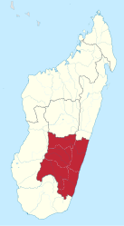
Fianarantsoa ( German good education ; also Fianar ) is a former province ( faritany mizakatena ) in Madagascar with the capital of the same name, Fianarantsoa . It had an area of 102,373 km² and around 3.36 million inhabitants. On April 4, 2007, Marc Ravalomanana held a referendum on an amendment to the constitution, which established a new administrative structure without provinces from October 2009.
There are four large national parks in the province: Ranomafana National Park , National Park Midongy du Sud , Isalo National Park and the National Park Andringitra .
Administrative division
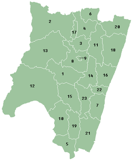
Until October 2009 Madagascar was divided into six provinces ( faritany mizakatena ). The regions (Faritra) founded in 2004 were the second administrative unit until the provinces were dissolved. From November 2009 they became the first administrative unit. The regions are each divided into districts ( Fivondronana ). The breakdown for the former Fianarantsoa Province is shown below.
|
|
Individual evidence
- ↑ Atukwei Okai: Mandela the Spear and Other Poems . African Books Collective, ISBN 978-0-9921875-1-4 , pp. 99 (English, google.de [accessed on November 19, 2017]).
- ↑ Administrative units - Madagascar ( Memento of December 21, 2008 in the Internet Archive )
- ↑ Diana. Ministère de l'Economie et du Plan, accessed on November 19, 2017 (French).

