Finke River
| Finke River | ||
|
Finke River in the Lake Eyre Basin |
||
| Data | ||
| location | Northern Territory / South Australia , Australia | |
| River system | Warburton River | |
| Drain over | Macumba River → Warburton River → Lake Eyre | |
| source | at Glen Helen Resort in the MacDonnell Ranges 23 ° 35 ′ 50 ″ S , 132 ° 32 ′ 38 ″ E |
|
| Source height | 652 m | |
| Infiltration |
Macumba River ( Witjira National Park / Simpson Desert ) Coordinates: 26 ° 14 ′ 46 ″ E , 135 ° 58 ′ 25 ″ E, 26 ° 14 ′ 46 ″ S , 135 ° 58 ′ 25 ″ E |
|
| Mouth height | 98.5 m | |
| Height difference | 553.5 m | |
| Bottom slope | approx. 0.92 ‰ | |
| length | approx. 600 km (at high tide approx. 750 km) | |
| Left tributaries | Ormiston Creek, Ellery Creek, Merrick Gully, Illawilla Creek, Maloney Creek, Hugh River , Hale River | |
| Right tributaries | Davenport Creek, Rudalls Creek, Bagot Creek, Palm Creek, Little Palm Creek, Circle Gully, Phillip Creek, Norman Gully, McMinn Creek, Five Mile Creek, Fifteen Mile Creek, Palmer River , Fifteen Mile Creek, Lilla Creek, Goyder Creek, Coglin Creek | |
| Flowing lakes | Tharmandilla Waterhole | |
| Medium-sized cities | Hermannsburg | |
| Small towns | Finches | |
| Communities | Glen Helen Resort, Henbury, Idracowra, Horseshoe Bend, New Crown, Mount Dare | |
|
Finke River |
||
|
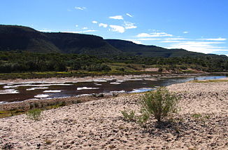
Finke River after rain |
||
|
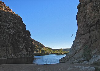
Finke River at the permanent waterhole in Glen Helen Gorge |
||
The Finke River is a river in the south of the Australian territory Northern Territory and the north of South Australia .
It is one of the longest rivers in Central Australia . It is an intermittent body of water : it falls dry outside of the rainy season and usually only consists of a series of water holes. As an upside-down river , however, water often also flows below its dry river bed. During the rare storms, however, it can turn into a torrent.
geography
course
The Finke River arises on the southern edge of the MacDonnell Ranges in the Northern Territory west of Alice Springs from the confluence of Davenport Creek and Ormiston Creek a little north of Glen Helen Resort . This area is part of West MacDonnell National Park . At Glen Helen Resort he breaks through a mountain range in a ravine for the first time. Then the river meanders for around 600 kilometers in a southeast direction. South of Hermannsburg within the Finke Gorge National Park , it passes in another gorge - the Finke Gorge between the Krichauff Range and the James Range . There is the Boggy Hole , a year-round watering hole . The Stuart Highway crosses the river about 110 kilometers south of Alice Springs .
In the further course, the Finke River passes a drier area until it reaches the western edge of the Simpson Desert in the northern part of South Australia . The Witjira National Park usually loses its track. In rare cases, the water flows from the Finke River into the Macumba River , also to Finke River Basin is counted and in the Lake Eyre opens . In this condition, the course of the river measures around 750 kilometers.
Tributaries with mouth heights
- Ormiston Creek - 652 m
- Davenport Creek - 652 m
- Rudalls Creek - 599 m
- Bagot Creek - 578 m
- Palm Creek - 553 m
- Little Palm Creek - 540 m
- Ellery Creek - 523 m
- Merrick Gully - 497 m
- Circle Gully - 496 m
- Phillip Creek - 495 m
- Norman Gully - 486 m
- McMinn Creek - 457 m
- Illawilla Creek - 441 m
- Maloney Creek - 415 m
- Five Mile Creek - 402 meters
- Fifteen Mile Creek - 396 meters
- Palmer River - 384 m
- Hugh River - 316 m
- Fifteen Mile Creek - 300 meters
- Lilla Creek - 280 m
- Goyder Creek - 233 m
-
Hale River - 189 m
The Hale River drains mostly 75 km north of the mouth in the Simpson desert. It only overflows into the Finke River in very wet years. - Coglin Creek - 184 m
Flowing lakes
The Finke River flows through waterholes, which are usually filled with water even when the river itself is dry. The most important are:
- Glen Helen Gorge Water Hole , permanent water hole - approx. 630 m
- Boggy Hole , permanent water hole
- Thamandilla Waterhole - 145 m
history
Human history
The Finke River was given its name by John McDouall Stuart in 1860. He was honoring Wiliam Finke, a man from Adelaide who supported Stuart's expedition. In 1872 the river was explored by Ernest Giles.
The Aborigines in parts of the Northern Territory call the river Larapinta . The dry river bed served them as a trade route through the outback for millennia .
Geological origin
The Finke River has long been called the oldest river on earth . For example, it meanders deeply through the mountains in the James Range . Since meanders can only arise in flat plains, the river bed must have been formed before the mountain range rose. The mountain formation in this area - known as Alice Springs orogeny - is dated between 400 and 300 million years (in the Devonian and Carboniferous ). Thus, parts of the river course must have already existed at this time.
The southern parts, on the other hand, must be somewhat younger, as the region in what is now the border area between Northern Territory and Southern Australia in the Mesozoic Era was flooded by the sea, which led to the formation of the Great Artesian Basin . So the age of the Finke River is not unique. Other major mountain river systems in Central Australia, such as the Todd River and the Hale River , also emerged during the same period. There are also other eroded mountains in Australia and other continents that are the same age or older than the MacDonnell Ranges. Today's rivers in these areas could have developed from rivers of the same age or older than the Finke River.
Flora and fauna
Despite its course through dry areas and desert, the river is home to many animals and plants. Pelicans can even be found at the Boggy Hole . The Finke Hardy Head ( Craterocephalus centralis ) is an endemic species of the family of silversides , like the Wüstengrundel chlamydogobius japalpa .
The Marienpalme (Livistona mariae) in the Finke Gorge National Park is unique in the world .
See also
- List of rivers in the Northern Territory
- List of rivers in South Australia
- List of rivers in Australia
Web links
- Bureau of Rural Sciences: Finke River - River Bassin Summary (PDF file; 418 kB)
- Ingrid Weidig at the Boggy Hole
Individual evidence
- ↑ a b c d e Map of Finke River Bonzle.com
- ^ Steve Parish: Australian Touring Atlas . Steve Parish Publishing, Archerfield QLD 2007. ISBN 978-1-74193-232-4 . P. 72 + 101
- ↑ a b Susannah Farfor, David Andrew, Hugh Finlay: Northern Territory . 3. Edition. Lonely Planet, Melbourne 2003, ISBN 1-74059-199-2 , pp. 254 (English, limited preview in Google Book search).
- ↑ Glen Helen Resort. (No longer available online.) Archived from the original on September 2, 2011 ; Retrieved September 28, 2011 . Info: The archive link was inserted automatically and has not yet been checked. Please check the original and archive link according to the instructions and then remove this notice.
- ^ Finke River: Northern Territory Place Names Register. Retrieved January 30, 2009 .
- ↑ Welcome to Australia. (No longer available online.) Archived from the original on December 5, 2015 ; Retrieved January 30, 2009 . Info: The archive link was inserted automatically and has not yet been checked. Please check the original and archive link according to the instructions and then remove this notice.
- ^ Larapinta Drive: Northern Territory Place Names Register. Retrieved January 30, 2009 .
- ↑ Pickup G, Allan G, Baker, VR: History, palaeochannels and palaeofloods of the Finke River, central Australia . In: Fluvial Geomorphology of Australia (edited by Warner RF), Academic Press, London . 1988, pp. 177-200.
- ^ A b Wells AT, Forman DJ, Ranford LC, Cook PJ: Geology of the Amadeus Basin, Central Australia . In: Bureau of Mineral Resources, Australia, Bulletin . 100, 1970.
- ↑ Haines PW, Hand M, Sandiford M: Palaeozoic synorogenic sedimentation in central and northern Australia: a review of distribution and timing with implications for the evolution of intracontinental orogens . In: Australian Journal of Earth Sciences . tape 48 , 2001, p. 911–928 , doi : 10.1046 / j.1440-0952.2001.00909.x ( article as PDF ).
- ↑ Mabbutt JA: Denudation chronology in central Australia: Structure, climate and landform inheritance in the Alice Springs area . In: Landform Studies from Australia and New Guinea (edited by Jennings JN, Mabbutt JA), Australian National University Press, Canberra . 1967, pp. 144-181.
- ↑ Desertfishes.org
- ↑ Craterocephalus centralis in the endangered Red List species the IUCN 2008. Posted by: R. Wager, 1994. Retrieved on January 30 of 2009.


