
Fiora
| Fiora | ||
 The Fiora between Cellena (district of Semproniano) and Selvena (Castell'Azzara) |
||
| Data | ||
| location | Italy , Tuscany ( Province of Grosseto ) and Latium ( Province of Viterbo ) | |
| River system | Fiora | |
| River basin district | Appennino Settentrionale | |
| source |
Santa Fiora ( Province of Grosseto ) 42 ° 49 ′ 51 ″ N , 11 ° 35 ′ 2 ″ E |
|
| muzzle | at Montalto Marina (district of Montalto di Castro ) in the Tyrrhenian Sea Coordinates: 42 ° 20 ′ 0 ″ N , 11 ° 34 ′ 0 ″ E 42 ° 20 ′ 0 ″ N , 11 ° 34 ′ 0 ″ E
|
|
| length | 80 km | |
| Catchment area | 825 km² | |
| Left tributaries | Lente , La Nova, Olpeta, Timone | |
| Right tributaries | Rigo | |
| Communities | Santa Fiora , Semproniano , Castell'Azzara , Sorano , Manciano , Pitigliano (all GR ), Farnese , Canino , Montalto di Castro (all VT ) | |
The Fiora is an 80 km long river in Italy, which crosses the provinces of Grosseto ( Tuscany ) and Viterbo ( Lazio ) from north to south and flows into the Tyrrhenian Sea at Montalto Marina (district of Montalto di Castro ) . It flows through the Tuscany region on 51.2% of its course and the Lazio region on 48.8%.
course
The river is named after St. Flora di Cordova from Córdoba († November 24, 851 ibid.). The river, previously called Armenta , Armine or Armino (up to the 13th century) by the Etruscans and Romans , rises on the south-western slope of Monte Amiata in the municipality of Santa Fiora . Here it flows through the third of Montecatino , where it passes the fish farm Peschiera and the church Chiesa della Madonna della Neve and continues south past the Selva district . Then it forms the municipal boundary between Semproniano and Castell'Azzara and enters the municipality of Sorano , where it touches the district of Sovana on the left. On the opposite side it touches the district of San Martino sul Fiora in the municipality of Manciano . Shortly behind and south of Sovana, the 20 km long river Lente joins the Fiora from the left. Also in Manciano it flows through the nature reserve Riserva naturale Montauto . Pitigliano is his last municipality in Tuscany , where it becomes the border between the region of Tuscany and Lazio and the provinces of Grosseto and Viterbo (municipality of Farnese ) west of the Pian di Morrano district . The 36 km long river Olpeta flows in from the left at Ponte San Pietro . The border function is fulfilled by the Fiora to Vulci (today part of Montalto di Castro ), where it finally crosses into the Lazio region and there passes the Ponte dell'Abbadia . After a short stay in the municipality of Canino , he returned to Montalto di Castro and first touched Casa Campomorto and then the center of Montalto di Castro. After about 5 km the river ends at Montalto Marina in the Tyrrhenian Sea .
Valle del Fiora
The Fioratal (Italian: Valle del Fiora , sometimes also called Val di Fiora or Valle della Fiora ) also includes places that are not directly on the river, such as Pitigliano, Saturnia and Sorano. The valley was first settled by Homo erectus .
Riserva Naturale Montauto Natural Park
The nature reserve Riserva Naturale Regionale di Montauto is located in the municipality of Manciano . It was created in 1996 and has an area of 199 hectares . It is at the southern end of Manciano and borders the Lazio region.
photos

Fiora bridge near Pitigliano

The Fiora near Vulci with the Ponte dell'Abbadia and the Castello
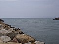
The mouth of the Fiora into the Tyrrhenian Sea at Montalto Marina


literature
- Giorgio Battini: Il fiume racconta. Viaggio nella Toscana dei fiumi. , Bonechi, Florenz 1993, ISBN 88-7009-941-5 , p. 201 ff.
- Emanuele Repetti: VALLE DELLA FIORA o VAL DI FIORA. In Dizionario Geografico Fisico Storico della Toscana (1833–1846), online edition of the University of Siena (pdf, ital.)
Web links
- Official website of the Sistema Informativo Ambientale della Regione Toscana (SIRA) on the river Fiora (Italian)
- Official website of the Autorità di Bacino del Fiume Fiora (Italian)
- Fiumi Italiani website on the Fiora River (Italian)
Individual evidence
- ↑ a b Official website of the Autorità di Bacino del Fiume Fiora on the Fiora River, accessed on January 24, 2012 (Italian)
- ↑ a b Giorgio Battini
- ↑ a b Emanuele Repetti
- ↑ Official website of the Gruppo Archeologico Torinese on the Valle del Fiora, accessed on January 25, 2012 (Italian) (PDF file; 5.43 MB)
- ↑ Parco degli Etruschi website on the Riserva Naturale Regionale di Montauto, accessed on January 25, 2012 (Italian) ( page no longer available , search in web archives ) Info: The link was automatically marked as defective. Please check the link according to the instructions and then remove this notice.