
Hofstetten-Flüh
| Hofstetten-Flüh | |
|---|---|
 |
|
| State : |
|
| Canton : |
|
| District : | Dorneck |
| BFS no. : | 2476 |
| Postal code : | 4112 Flüh 4114 Hofstetten |
| UN / LOCODE : | CH YFL (Flüh) |
| Coordinates : | 605 779 / 258559 |
| Height : | 462 m above sea level M. |
| Height range : | 379–837 m above sea level M. |
| Area : | 7.52 km² |
| Residents: | 3157 (December 31, 2018) |
| Population density : | 420 inhabitants per km² |
| Website: | www.hofstettenflueh.ch |
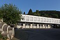
 Street in Flüh and the church of Hofstetten |
|
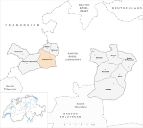
| Location of the municipality | |
  |
|
Hofstetten-Flüh ( pronounced Hufstette-Flüe in the dialect , officially called Hofstetten (SO) until 1985 ) is a political municipality in the Dorneck district of the canton of Solothurn in Switzerland .
population
- Proportion of foreigners: 11%
- Religion: 41% Roman Catholic , 28% Reformed
geography
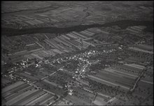
The municipality of Hofstetten-Flüh consists of the two districts of Hofstetten at 462 m above sea level. M. and Flüh at 379 m above sea level. M. in a Solothurn enclave in the rear Leimental . In the district of Flüh the pass road begins up to the Challpass and on to Röschenz , which is already located in the canton of Basel-Land .
In terms of population, it is the largest municipality in the Solothurn Leimental . Its neighboring communities are the Solothurn Metzerlen-Mariastein , Bättwil and Witterswil , the Basellandschaftliche Ettingen and Blauen BL , and the French Leymen .
- Area: 752 ha , of which 45% was forest, 39% agriculture, 15% settlements and less than 1% unproductive land in 2014
coat of arms
- Two red posts in white; in the red head of the shield a white six-pointed star. This was the family coat of arms of the Lords of Hofstetten
history
Life in the church goes back a long way. The first provable inhabitant of the area was a mammoth , which lost one of its tusks around 12,000 BC at the end of the last ice age .
Around 400 BC, Celts settled here. They belonged to the Rauriker tribe and from them the remains of iron smelting plants, so-called racing furnaces, were found . The Romans also seemed to like it here, as they built a manor in the 1st century. During construction work one found the remains of this property and next to it sparse remains of a small building, as well as the foundations of craftsmen's houses and part of the surrounding wall.
In the 6th century, the Alemanni settled here and displaced the Roman population. In the valley mats in Flüh they left a cemetery with several graves. These contained very beautiful grave goods, including a belt buckle, finger rings and glass beads.
In the Middle Ages , Hofstetten-Flüh, together with six other villages on the Blauen, was a free imperial fief and was therefore directly subordinate to the emperor. From the 13th century to the end of the 14th century, the Lords of Hofstetten lived in Sternenberg Castle between the two villages. Your coat of arms became the coat of arms of the municipality. The Sternenberg castle was destroyed by fire around 1450 and has been in ruins ever since.
From 1408 the villages were subordinate to the Lords of Rotberg , who had their ancestral castle not far from the western municipality border on the Blauenhang. In 1515 the Rotbergers sold their rule to the city of Solothurn . This explains why the lower Leimental is now part of the canton of Solothurn . The Burg Rotberg disintegrated over time into ruin and was used as many other ruins as a welcome storage of building blocks. The Rotberg was rebuilt in 1934 and is now used as a youth hostel.
The Solothurn rule brought a quiet time. They were now serfs of the Solothurn family, who had the leimental administered by the Vogt at Dorneck Castle in Dornach . But a multitude of burdensome taxes, the social differences between full farmers, half farmers and Tauners , as well as the control of everyday things did not make life easy. Therefore, many Hofstetter and Flüh-ner moved abroad and into foreign military service because they had no livelihood in their own village.
In the 19th century Hofstetten was still a poor farming village and Flüh consisted mainly of craft businesses and taverns, which were quite well visited on the pilgrimage to Mariastein . When Basel's industry expanded towards the end of the century, workers from the villages around the city were in demand. That is why a railway line to Basel was built in 1888 , which is now operated by the BLT and leads to Rodersdorf, which enabled the Hofstetter and Flühner to find work in Basel . But the train also brought day trippers to the country.
economy

The community is located in the large economic area of north-west Switzerland and can benefit from its proximity to the city of Basel. Nevertheless, Hofstetten-Flüh is not a sleeping community. It offers a large number of jobs in many small and medium-sized enterprises ( SMEs ) and is also quite strong in the service sector.
traffic
Traffic Moderately Flüh is with the post bus line 69 to Mariastein or Metzerlen and the station Flüh-Mariastein leading into the city of Basel BLT - Tram 10 well developed. Hofstetten, located at the top, can be reached directly by bus 68 either from Flüh or Ettingen. Depending on the waiting times, the journey from Hofstetten to Basel takes between 30 and 45 minutes.
photos

Mammoth hall, municipal administration

Primary school since 2014

Old schoolhouse since 1833
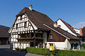
Old Sundgauerhaus, Raiffeisenhaus
Catholic Church of St. Nicholas

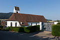
Chapel of St. John

1. Ecumenical Church of Switzerland, Flüh
Primary school in Flüh

Flühmühle in Flüh
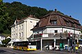
Flüh-Mariastein tram stop
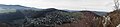
Panoramic view of Marienstein Abbey and Landskron Castle from Hofstetter-Chöpfli.


Attractions
- Sternenberg ruin
- Fürstenstein ruins
- St. John's Chapel
- Throat canyon
- Hofstetter mountain mat
- Heiliggeistkirche (Flüh)
- Forum Flüh, art exhibitions
literature
- Gottlieb Loertscher: The art monuments of the canton of Solothurn, Volume III: The districts of Thal, Thierstein, Dorneck. (= Art Monuments of Switzerland. Volume 38). Edited by the Society for Swiss Art History GSK. Bern 1957, DNB 750089342 .
Web links
- Official website of the municipality of Hofstetten-Flüh
- Lukas Schenker: Hofstetten-Flüh. In: Historical Lexicon of Switzerland .
Individual evidence
- ↑ Permanent and non-permanent resident population by year, canton, district, municipality, population type and gender (permanent resident population). In: bfs. admin.ch . Federal Statistical Office (FSO), August 31, 2019, accessed on December 22, 2019 .