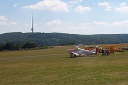
Hirzenhain airfield
| Hirzenhain airfield | |
|---|---|

|
|
| Characteristics | |
| ICAO code | EDFI |
| Coordinates | |
| Height above MSL | 520 m (1706 ft ) |
| Transport links | |
| Distance from the city center | 1 km south of Eschenburg-Hirzenhain |
| Street | L3043 |
| Basic data | |
| opening | 1966 |
| operator | SFC HiHai |
| Start-and runway | |
| 11/29 | 600 m × 30 m grass |
The airfield Hirzenhain is a special airfield in Eschenburg - Hirzenhain in the Lahn-Dill-Kreis , Hesse .
The airfield is operated by the Glider Pilot Club HiHai eV and is primarily used for gliding . In addition, the following are permitted:
- Powered aircraft (up to 2000 kg)
- Motor sailer
- Model airplanes
history
When the Hirzenhain airfield on the "Eiershäuser Hang", which had existed since the 1920s, was closed for safety reasons in 1961, planning began for a new airfield on the other side of the village. In 1964 construction began on the "Great Cattle Pasture". Because of many unexpected difficulties, the airfield was completed at the end of 1965 with the help of an American pioneer unit. The official inauguration took place in 1966.
Location and directions
The airfield is located on a high plateau in the Gladenbacher Bergland at an altitude of approx. 520 meters. The state road L3043 leads directly past the square. The Dillenburg motorway junction on the A 45 is approx. 14 km away.