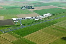
Reichelsheim airfield
| Reichelsheim airfield | |
|---|---|

|
|
| Characteristics | |
| ICAO code | EDFB |
| Coordinates | |
| Height above MSL | 121 m (397 ft ) |
| Transport links | |
| Distance from the city center | 2.5 km south of Reichelsheim (Wetterau) , 28 km north of Frankfurt am Main |
| Street | K178 |
| Basic data | |
| opening | August 18, 1962 |
| operator | Reichelsheim-Wetterau Airfield GmbH & Co. KG |
| Flight movements |
approx. 48,000 |
| Runways | |
| 18/36 | 1300 m × 23 m asphalt |
| 09/27 | 250 m × 30 m grass |
The reichelsheim airport is a German airfield in the Hessian Wetterau , about 30 minutes drive north of Frankfurt am Main .
Flight operations
It is classified as a commercial airfield and approved for airplanes and helicopters up to 8000 kg (max. Take-off mass), motor gliders , ultralight aircraft , airships and hot air balloons . The 1,300 m long asphalt runway is designed for night flight operations and is equipped with precision glide slope lighting (PAPI) .
Reichelsheim relieves and complements Frankfurt Airport as a northern alternative in the general aviation segment . The airfield is open all year round and is a customs airfield. The operator is the Flugplatz Reichelsheim-Wetterau GmbH & Co. KG.
The airfield is home to aviation companies , flight schools , aviation companies and an air sports club.
Reichelsheim is the base of the intensive care transport helicopter Christoph Mittelhessen of Johanniter-Unfall-Hilfe eV. The air rescue center Hessen is located at the airfield. Transplant and ambulance flights are carried out across Europe via Reichelsheim on behalf of the German Organ Transplantation Foundation .
Location and transport links
The airfield is located in the Wetteraukreis in central Hesse between Reichelsheim and Florstadt . The airfield can be reached via the A 5 junction Friedberg or the A 45 motorway junction Florstadt or Wölfersheim . There is a connection to the Rhein-Main S-Bahn to Frankfurt am Main via the Friedberg train station . Long-distance trains in the direction of Giessen, Kassel, Hamburg, Heidelberg and Karlsruhe also stop there. Kreisstraße 178, which runs past the airfield, was renovated and expanded in 2007 and was given a combined foot and bicycle path.
Expansion of the runway
Originally there were two runways: a 775 m long asphalt runway in north-south orientation and a 400 m long grass runway in east-west orientation. In December 2004, the asphalt railway in the north received a safety allowance of 375 m (gravel stretch) in order to meet EU regulations. In spring / summer 2007 a new runway was built 55 m east of the old runway with a length of 1300 m and a width of 23 meters. This has been in operation since July 2007. The old runway was reduced to a taxiway and extended. The existing grass runway was shortened to a length of 250 m in the course of the expansion. A special feature of the airfield are the two bridges over the Horloff river , which connect the apron with the runway system.
Incidents
- On Whitsunday, June 12, 2011, an American Blimp Corporation A-60 airship crashed here . The airship commander died in the accident; the three passengers were able to save themselves by jumping.
- On December 8, 2012, two small aircraft collided, one of which was approaching the airfield. All eight occupants died (see plane collision near Wölfersheim ).
