
Franciscan monastery Heilbronn

The Franciscan monastery in Heilbronn was a monastery community that had existed since the 13th century. The monastery was closed in 1544. Parts of the monastery building were demolished in 1925, the remains destroyed in 1944. The monastery church St. Marien und Franziskus, consecrated in 1314, was destroyed in 1688, the tower of the church, which was rebuilt until 1727, is known today as the harbor market tower.
history

Franciscan order in Heilbronn 1290–1544
The brothers of the Franciscan Order founded in 1210 ( Ordo fratrum minorum "Friars Minor", also " Barefooted ") were first mentioned in Heilbronn in 1272 and built a monastery in angulo civitatis ("in a corner of the city"), although the layout and location have not been handed down are. The year 1290 on a coat of arms on the vault of the later St. Mary's Church of the Franciscan Order in Heilbronn is interpreted as the year the foundation stone was laid for the church. The first burial in the church did not take place until 1290. In 1309 King Heinrich IV took part in a service in the later St. Mary's Church when he met Archbishop Peter von Mainz in Heilbronn in August of that year . After the sermon, Brother Mathäus announced that a messenger from Pope Clement V had arrived and had brought the invitation to the imperial coronation. In 1314 the monastery church was given the patronage of the Virgin Mary and St. Francis consecrated ; this is evidenced by the building inscription ADMCCCXIV consecrata est haec eccelsia in hon. s. Virginis and Beati Franicisci .
The friars were buried under the monastery church. Heilbronn patrician families and patrons of the monastery from the lower nobility of the surrounding area also placed great value on burial in this location. Among those buried in the church were relatives of the Counts of Löwenstein , the Marschallen von Hohenried, the Lords of Rosenberg , Helmstatt , Liebenstein , Berlichingen , Venningen , Waiblingen, Talheim , Validlingen , Frauenberg, Rechberg , Holz, Hornberg , Adelsheim , Mentzingen and Gemmingen as well as the patrician families Erer , Feurer, Sandritter, Berlin, Schreiber, Stirner, Ansen, Waller, Walther, Lorcher, Laemmlin and others.
The Franciscans in Heilbronn lived in simple circumstances. The convent belonged to the Upper German (Strasbourg) order province of Argentina , founded in 1239 , which represented a relaxed conception of poverty and allowed limited property (usus moderatus) . There was an external procurator for each Franciscan monastery to manage the property . In Heilbronn, Konrad Leineweber is documented in this office in 1339. The monastery lived mainly on natural produce, which it received as alms from its collection district between Pforzheim , Esslingen , Brettach and Obergriesheim . The monastery friars were only allowed to collect additional alms if what they had was insufficient for a living.
Over time, in the Heilbronn monastery, as elsewhere in the Franciscan order, there was a flattening of observance regarding the vow of poverty corresponding to the rule of the order . So soon people within the order had a different view of poverty, gave up the habit , allowed private property of the brothers or accepted favors. The Heilbronn Franciscan monastery and the Klarakloster of the Poor Clares , also located in Heilbronn, were therefore also the target of reforms by Pope Paul II and the internal observance movement in the years 1465/66 and the following period .
If these were still reforms within the Catholic Church, the further course of the Reformation with its criticism of the monastic system led to the division of the Church. The Franciscans, in Heilbronn including the brother Johann Eberlin von Günzburg († 1533), rejected the Reformation and found support from Catholic princes. For monasteries in Reformation-minded imperial cities such as Heilbronn, Nuremberg and Ulm, however, the decline began.
As early as 1525, the city council of Heilbronn took control of the Franciscan monastery through various regulations. In 1529 the Heilbronn council announced that they wanted to take possession of the monastery in order to build an armory at its location . Then the demolition of the monastery walls began. For the time being, however, the monastery received support from Georg Truchsess von Waldburg-Zeil († 1531), who obtained a mandate from the Imperial Court of Justice to stop the demolition work. After the Truchsessen death, the city of Heilbronn forbade the Franciscans to celebrate various masses in December 1531 and at the same time offered them a benefice in case they gave up the monastery. As the friars could not be won over, they were harassed with all sorts of harassment that led to the convent becoming extinct. In 1542 two brothers were still living in the monastery. The last died in 1544, after which the Reformation-minded city closed the monastery. The Franciscan order made several attempts to have the monastery returned, for example in 1549 and during the Thirty Years' War in 1629, but the order remained unsuccessful and the complex was owned by the city of Heilbronn.
Use after 1544

Convent building
The city of Heilbronn used the monastery as the new domicile of the Latin school after 1544 , and in 1566 the provincial of the Franciscan order also formally left the former monastery complex to the city. In 1575 the cloister and convent served the council library. Until after the construction of the Karlsgymnasium for boys in 1827, some classes continued to be taught in the former monastery. In the 19th century, a total of four major extensions and renovations were carried out on the building, which at times housed several schools, including the girls' college and, until 1889, the Heilbronn trade school . In 1925 the cloister of the monastery was demolished when the inner courtyard was roofed (for use as a gym). In the great air raid on Heilbronn in 1944, the monastery building was completely destroyed.
Monastery church


The Marienkirche became a Protestant church after 1544. In 1688 the church building was destroyed by the French army. The city council then tried to raise funds for the reconstruction. After not having enough money, Emperor Leopold I issued a nationwide donation patent around 1698 to rebuild the church, which meant that at least one tower of the church (the harbor market tower ) could be rebuilt by building officer Johann Philipp Meyer by 1727. Since it became apparent that the reconstruction of the nave could not be financed, the Nikolaikirche , which had been profaned before, was consecrated again in 1706.
Around 1800 the harbor market tower served as a shotgun factory. The base area was redesigned from 1926 to 1936 as a memorial for those who died in the First World War. In the course of the reconstruction after the Second World War, a phoenix bird (designed by Heinrich Röhm in 1951) was installed on the top of the tower, the base area was converted into a passage in 1963, where further memorials for victims of war and displacement are installed.

The harbor market tower around 1868

The harbor market tower as seen from the Kiliansturm
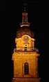
The harbor market tower at night

Passage in the harbor market tower with cenotaph


literature
- P. Adalbert Ehrenfried (OFMCap): Barefooted and Poor Clares in Heilbronn . Ehrenfried, Zell a. H. 1977.
- Lukas Wadding (Franciscan): Annales Minorum, seu trium ordinum a. S. Francisco institute. Rome 1930.
- Marianne Dumitrache, Simon M. Haag: Heilbronn . Landesdenkmalamt Baden-Württemberg, Stuttgart 2001, ISBN 3-927714-51-8 ( Archaeological city register Baden-Württemberg. Volume 8)
- W. Hofmann: The reform of the Heilbronn minorite monasteries in 1465 . In: Swabia and Franconia. Local history supplement of the Heilbronn voice . 3rd year, no. 1 . Heilbronner Voice publishing house, November 24, 1956, ZDB -ID 128017-X .
Web links
- Franciscan monastery Heilbronn in the database of monasteries in Baden-Württemberg of the Baden-Württemberg State Archives
Coordinates: 49 ° 8 ′ 33.7 ″ N , 9 ° 13 ′ 14.5 ″ E