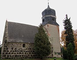
Frauenhorst
|
Frauenhorst
City of Herzberg (Elster)
Coordinates: 51 ° 42 ′ 51 ″ N , 13 ° 12 ′ 25 ″ E
|
|
|---|---|
| Height : | 78 m above sea level NHN |
| Incorporation : | 1st January 1974 |
| Postal code : | 04916 |
| Area code : | 03535 |
Frauenhorst is an inhabited part of the municipality of the city of Herzberg (Elster) in the district of Elbe-Elster in Brandenburg . The place is on the Black Elster .
history
The place was first mentioned in 1269 in the Dobrilugk document book as (Borchardo militi de) Vrowenhorts . The name of the former manor indicates that women were worshiped. Horst indicates a hill in the bushes or an elevation in the swamp area .
Until 1815 the place belonged to the office of Annaburg . In 1550, 19 possessed men lived here, including 13 Huefners, a liege judge and five gardeners who were directly subordinate to the Lochau office. However, one man paid his interest to the pastor in Herzberg.
The town hall bordered with the Annaburger Heide , Grochwitz and Mahdel .
Frauenhorst originally did not have a church, but was a branch of Herzberg.
Web links
- Frauenhorst in the genealogical directory
Individual evidence
- ↑ City of Herzberg (Elster) - districts according to § 45 municipal constitution - inhabited districts - living spaces. In: service.brandenburg.de. Ministry of the Interior and Local Affairs of the State of Brandenburg, accessed on November 6, 2016 .
- ↑ BrandenburgViewer of the state survey and geographic base information Brandenburg (LGB)
- ^ The place names of the Schweinitzer Land, Akademie-Verlag, Berlin 1964, Walter Wenzel
