Arnsnesta
|
Arnsnesta
City of Herzberg (Elster)
Coordinates: 51 ° 44 ′ 19 ″ N , 13 ° 10 ′ 22 ″ E
|
|
|---|---|
| Height : | 79 m above sea level NHN |
| Area : | 4.97 hectares |
| Incorporation : | December 31, 2001 |
| Postal code : | 04916 |
| Area code : | 03535 |
|
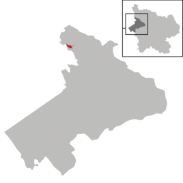
Location of Arnsnesta in Herzberg (Elster)
|
|
Arnsnesta is a district of the official city of Herzberg (Elster) in the Elbe-Elster district in Brandenburg . Until it was incorporated into the city of Herzberg (Elster) in 2001, Arnsnesta was an independent municipality. The place is located directly on the Black Elster .
Geographical location
Arnsnesta is on the right-hand side of the Schwarzen Elster and has the typical characteristics of a row village . Most of the farms and family houses are to the left and right of the central main street . The plots in the north mostly have a connection to the also north running side road.
history
Arnsnesta was first mentioned in a document in Sunnunwalde et Arnsneste in 1288 , in 1298 a Theodericus junior de Arnisnest is mentioned, then in 1348, Botho von Tourgaw (von Torgau) is the landlord. 1376-1387 the village is Arnesneste, 1550 Artznest . The name comes from the Germanic Arn , in German eagle, it can probably be interpreted as an eagle's nest .
The Lords of Torgau from the Wettin family built a moated castle on the then meandering Black Elster. At the same time, a Botho von Torgau built a castle on the upper Elbe in Bohemia that had well-fortified moats. This place was also named after the Arn Arnau , the Czech name is Hostinné .
Until 1815 the place belonged to the office of Annaburg . In 1550, 20 “possessed men” lived there, four of whom were coaches with a judge and 16 gardeners who were directly subordinate to the Lochau office. The town hall bordered with the Annaburger Heide on Premsendorf, Borken and Bernsdorf.
The Elstermühle , which was subordinate to the office and operated by Augustin Müller in 1550 , also belonged to Arnsnesta . It was the seat of a mill court in the 18th century. There was also a Freihof in the village that belonged to Hans von Hagenest . After his death in 1560, this man-made estate, which was under the control of the Dresden office, was converted into a hereditary estate. Arnsnesta already had its own pastor in the 16th century, and the church patronage belonged to the University of Wittenberg at that time . As of December 31, 2001, Arnsnesta was incorporated into the city of Herzberg (Elster).
Castle hill
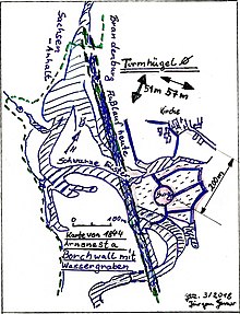
The castle hill is located 200 m southeast of the church on a flood plain on the right bank of the Black Elster and can still be recognized as a hill. The field name is Borchwall or Borchelt. In the 14th century the castle was surrounded by protective water arms. The castle was a circular to oval structure with approx. 51 meters in the north-south axis and 57 meters in the west-east extension. In 1902 archaeological excavations were carried out. The old course of the river ran approx. 60 meters west of today's castle hill. The remains of the castle were demolished in 1911–1912. The former castle is listed under the ground monument number 20368. (Map of the old river and moat)
landscape
To the west of the town is the Annaburger Heide , which is mainly used for military purposes as a military training area and also for forestry. The oxbow lakes of the Black Elster there form the former course of the river, which can still be easily recognized, before it was straightened and are of particular importance from a nature conservation perspective. These backwaters have developed into a refuge for protected plant species with plants such as water hazel , crayfish claws , swamp milkweed and others. The nature reserve Alte Elster and Rohrbornwiesen is particularly worth mentioning there .
Web links
- Arnsnesta in the Genealogical Directory
- Arnsnesta on the pages of Herzberg (Elster)
- Contribution to the RBB program Landschleicher on September 30, 2007
Individual evidence
- ↑ City of Herzberg (Elster) - districts according to § 45 municipal constitution - inhabited districts - living spaces. In: service.brandenburg.de. Ministry of the Interior and Local Affairs of the State of Brandenburg, accessed on November 6, 2016 .
- ↑ BrandenburgViewer of the state survey and geographic base information Brandenburg (LGB)
- ↑ Date of registration: 1348 12 21 Place: Dresden HstA Dresden, 1001, older documents, n. 3155 and 3156. Witnesses are Botho von Torgau, Herr von Arnau and Botho von Torgau, Herr von Arnsnesta
- ↑ Heimatbuch Elbe-Elster 1996, p. 86.
- ^ The place names of the Schweinitzer Land, Akademie-Verlag, Berlin 1964, Walter Wenzel
- ↑ Hostinné, The old home, Arnau an der Elbe in the Giant Mountains by Dr. Otto Weiss, Volume 1, pp. 55-60.
- ↑ lr-online.de
- ↑ Ines Walks: Medieval castles between the middle Elbe and Bober . In: Brandenburg State Museum for Prehistory and Early History (Hrsg.): Research on archeology in the state of Brandenburg, by Jürgen Kunow . tape 6 . Wünsdorf 1999, p. 215-216 .
- ↑ Landscape profile of the Annaburger Heide, ( Memento of December 13, 2010 in the Internet Archive ) at the Federal Agency for Nature Conservation
- ↑ Link to the nature reserves in the Elbe-Elster district;
- ↑ Link to the NSG Untere Schwarze Elster; ( Memento from September 28, 2013 in the Internet Archive )


