
Hostinné
| Hostinné | |||||
|---|---|---|---|---|---|
|
|||||
| Basic data | |||||
| State : |
|
||||
| Region : | Královéhradecký kraj | ||||
| District : | Trutnov | ||||
| Area : | 806 ha | ||||
| Geographic location : | 50 ° 32 ' N , 15 ° 43' E | ||||
| Height: | 351 m nm | ||||
| Residents : | 4,361 (Jan 1, 2019) | ||||
| Postal code : | 543 71 | ||||
| License plate : | H | ||||
| traffic | |||||
| Street: | Vrchlabí - Dvůr Králové nad Labem | ||||
| Railway connection: | Velký Osek – Trutnov | ||||
| structure | |||||
| Status: | city | ||||
| Districts: | 1 | ||||
| administration | |||||
| Mayor : | Dagmar Sahánkova (as of 2016) | ||||
| Address: | nám. 1. máje 69 543 71 hostinné |
||||
| Municipality number: | 579297 | ||||
| Website : | hostinne.info | ||||


Hostinné (German Arnau ) is a town in Okres Trutnov ( Trautenau district ) in the Czech Republic . The city center has a Renaissance town hall and a market with arcades.
geography
The city is located in the Sudeten on the upper reaches of the Elbe at an altitude of 351 m above sea level, about 15 km west of Trutnov ( Trautenau ). The region belongs to the foothills of the Giant Mountains .
history


The Arnau area originally belonged to the Trautenau feudal district. The town of Arnow , founded by Ottokar II. Přemysl , was first mentioned in 1270, making it the oldest in this region. It developed from a settlement near a castle, which was called Arnau by German colonists. The name comes from the Germanic Arn, in German eagle, it can probably be interpreted as an eagle's nest. The city lords of Torgau were an important Saxon-Bohemian ministerial family. In 1316 Potho von Turgow got the Veste Gradiss , the town of Arnau and the town of Hof from King Johann . If necessary, if the king called for help, 40 armed men had to be provided. With the court, the von Torgau took over the entire noble feudal people and vassals. Arnau thus became their headquarters. In addition to the well-fortified Arnau, they also built Arnsdorf on the Seifenbach on the upper Elbe and also a settlement called Arnsnesta on the Black Elster . From 1348 Arnau Castle was then firmly in the possession of Botho von Turgow ( Turgau , Torgau ), a son of Burgrave Purchart of Magdeburg who had emigrated to Bohemia shortly before (1316) . At this time, craftsmen and traders from Franconia, Bavaria and Silesia also immigrated. The von Kottwitz , a Franconian knight and noble family of previously Silesian-Saxon origin, gave the neighboring town of Kottwitz its name . During the reign of Emperor Charles IV , during his creation of New Bohemia (1355 to 1375), Franconian counties also submitted to the emperor. The Lords of Kottwitz belonged to the Teutonic Order of the County of Wertheim and came to the upper Elbe with Franconian settlers. In 1377 Arnau was mentioned as the property of Duke Bolko von Oppeln , from 1388 it belonged again to the von Turgow family (von Torgau). At the beginning of the 15th century the Turgov estates were hereditary divided, and Arnau fell to the Lords of Redern .
- Hussitten time
Around 1415 Tristan von Redern sold Arnau to Hynek Kruschina von Lichtenburg , who bought it for his underage brother Johann Kruschina von Lichtenburg . In 1424 the Hussites under Ziska besieged the city on Shrove Sunday and demanded a surrender, although the city belonged to the brother of the Hussite captain Hynek Kruschina von Lichtenburg, who did not submit to the emperor until 1428. Thereupon he won the favor of the royal court in Prague. 1424 are said to have been knights of the Rhodes , also known as cross brothers or sword brothers, in the German-speaking city . They had escaped from neighboring Trautenau to Arnau after the Hussites had pillaged and conquered the town of Trautenau with its hospital and church in 1421. Due to the military knowledge and instructions of the knights in defense of Arnau, the attacks of the Hussites could be repulsed. The knight Zdenko I. von Waldstein is said to have led the defense. If the Arnau defenders failed, over 100 Hussites lost their lives. Field chaplain Ziskas is also said to have been killed on Fiebig with a crossbow arrow, according to reports. Zizka then lifted the siege and withdrew, but then the Hussites, who were used to victory, destroyed the Rhodis monastery of St. Procop in the neighboring monks' village in retaliation. In 1425 the western upper gate was built in the city wall. In 1434 Johann Kruschina was murdered after a dispute with the Braunau city council, his possessions reverted to his brother Hynek.
In the years that followed, the city likely expanded eastward beyond today's market. After Hynek's death in 1454, his son Wilhelm Kruschina († ~ 1487) inherited the Arnau rule from his marriage to Anna von Hasenburg , but sold it in 1458 to his stepmother Anna von Kolditz . This made Arnau her widow's residence and is said to have been very charitable. She released her subjects from the stately taxes. Under their rule, the city expanded to the east. A new city wall was probably built, and the Niedertor was built in it in 1456. In 1458 the city mistress founded a hospital behind the new bourgeois quarter outside the city . Anna von Kolditz died on February 1, 1467. The Arnau lordship inherited their daughters Anna and Salome von Častolowitz , who were still alive at the time , as well as Euphemia and Regina von Lichtenburg from their marriage to Hynek. They sold the town and the Arnau rule in 1476 to Ulrich ( Oldřich ) Zajíc von Hasenburg , who was married to Anna von Častolowitz, and to his brother Johann, the husband of the late daughter Katharina von Častolowitz.

In 1477 Aleš Šanovec von Šanov ( Alex von Schönau ) acquired the Arnau estates, whose descendants shared the rule again. During this time, the New Council Book , which is still preserved today, was created with the writing of many events. In 1506 the citizenship obtained the right to brew brewing ( Kretscham ) and the exclusive right to drink in Kottwitz and Prausnitz, as well as to sell beer in Arnsdorf, Hermannseifen and Polkendorf. In 1519 Johann von Wartenberg bought both parts, but already sold them in 1521 to Zdeněk von Waldstein , among whose descendants the rule was again divided. In 1538 two weekly markets were held on the Ring. The first Lutheran pastor was installed in the parish in 1539. Around 1544, the raising of funds for school teachers at the Arnau School can be proven. Zdeněk von Waltstein expanded his property in the town, in 1591 he bought the Gernert town house with the town council's wine and beer cellars to the south for 910 shock and thus attracted the brewing trade as a source of money. The wine trade was of great importance in Arnau in 1579, the turnover of the wine tavern Merten Gernert and Jacob Heier was worth 617 shock per year. This corresponds to the amount of wine of 262 buckets (15,750 liters), that is 157 barrels of 100 liters each. From 1612 the citizens had to pay an annual flat rate of 50 shock to Hans Christof von Waldstein for their wine consumption. At the beginning of the Thirty Years War, the rule was jointly owned by Dietrich Waskabersky and Johann Ferdinand von Fünfkirchen .
After the Battle of White Mountain , the estate was confiscated and part of it was sold to Polyxena von Lobkowicz in 1623 for 6,000 guilders . In 1628 this was lifted and the entire rule was sold to Albrecht von Wallenstein for 36,057 shock and 20 groschen . After his killing in Eger, it was again confiscated in 1634 and sold to Guillaume Lamboy de Desseneur ( Wilhelm von Lamboi ) the following year . The von Wallenstein allowed the evangelical faith in some of their lordships for a few years through clever policies, also in Horni Branná until 1654. The evangelical church in Branná was the church of Rochlitz Protestants, some of whom had escaped from Arnau in 1637. Subsequent town owners were Octavian Kinsky von Wchinitz and Tettau from 1684 and his son Wenzel Norbert Octavian from 1699. These were followed from 1706 by Count Morzin and from 1719 by Count Schlick . In 1750 Maximilian Graf Lamberg acquired the rule; from him it passed in 1758 to Maria Anna von Schaffgotsch , from whom the property passed to Joseph von Bolza in 1762 . He acquired the Tschermna fiefdom before 1785 and added it to the rule. After Joseph Count von Bolza's widow had the rule bid, it was acquired in 1799 by Franz Count Deym von Střítež . After his death in 1832 it passed to his son of the same name. In 1834 Arnau consisted of 244 houses and had 1,439 inhabitants. The old fortifications were demolished in the 18th and 19th centuries. The economic development was shaped by the textile and paper industry.
The Arnau dominion had 10,314 inhabitants in 1834, all of whom were Catholic and predominantly German-speaking. In addition to the town of Arnau, the 20 villages Anseith ( Souvrať ), Bukowina ( Bukovina ), Burghöfel ( Dvoračky ), Güntersdorf ( Huntířov ), Gutsmuts ( Dobrá Mysl ), Karlseck ( Karlovka ), Katharinadörfel ( Ves Svaté Kateřiny ), Kommar were directly subordinate ( Komárov ), Kottwitz ( Chotěvice ), Mastig , Mastiger Bad ( Mostecké lázně ), Mittel Oels ( Prostřední Olešnice ), Neuschloß , Nieder Oels , Neustädtel , Nieder Prausnitz , Ober Oels , Ober Prausnitz , Oels-Döberney ( Debrné ) and Proschwitz as well Shares from Arnsdorf and Forst . In addition there was the attached Tschermna estate . Several Maierhöfe belonged to the rule. The Sybillenhof and the Neuschloß farm were managed directly. The courtyards Karlseck and the Arnauer Posthof were leased, while the courtyards Kottwitz and Burghöfel were emphytheutized. The forest districts Arnau, Anseith, Güntersdorf, Mastig, Neuschloß, Proschwitz and Tschermna belonged to the dominion. The renaissance castle built in place of the former castle was converted into a cotton mill in the 19th century.
In 1835 the kk priv. Paper factory Gebr. Kiesling from Ober Langenau bought the castle building and set up the paper factory "Elbemühle" in it, which was sold in 1839 to the industrialist Franz Ritter von Lorenz, since 1873 Ritter von Riesenstett (1806–1889). Together with the industrialist Carl Julius Eichmann (1805–1872) he founded the company Franz Lorenz Söhne & Eichmann in 1842 , and after 1865 Eichmann and Co. with the production of special papers, including banknote paper. The seat of the Arnau rulership was Neuschloß Castle .

After the abolition of the patrionomial rule, Arnau formed a municipality in the judicial district of Arnau and in the Hohenelbe district from 1850 . The completion of the Velký Osek – Trutnov railway in 1870 led to an economic boom in the town. After Eichmann and Co. purchased & Bible in Gutsmuts and 1870, the wood pulp mill nor the fine paper mill from left, Judge Mönchdorf and groundwood Teschnen / Těšnov in Kingdom Forest was established, it was renamed in 1871 as kk priv. Papierfabriks- and publishing company Elbemühl with just under 500 employees.
In 1872 Arnau received a high school, which in 1873 moved into its own high school building. At the beginning of the 20th century, Arnau was the seat of a district court and an industrial site.
After the defeat in World War I , Austria-Hungary was dissolved and Czechoslovakia was founded. In the Treaty of Saint-Germain , the right of self-determination of the German Bohemians and German Moravians , who founded the independent provinces of German Bohemia and Sudetenland in October 1918 , was not taken into account.
At the 1930 census, the place had 4502 inhabitants (602 Czechs = 13%). In 1939 there were 4272. Arnau came to the German Reich in 1938 through the Munich Agreement . Until 1945 Arnau belonged to the district Hohenelbe in the administrative district of Usti nad Labem in the Reich District of Sudetenland . Between May 1942 and March 1944 the Germans ran a forced labor camp in Arnau with around 120 Jewish women.
After the end of the Second World War , the Sudetenland was again placed under Czechoslovak administration. In the following years, the majority German-speaking population of Arnau was sold . Her property was confiscated by Beneš Decree 108 and the Catholic Church expropriated during the communist era from 1948 to 1989 . The population fell sharply.
After the Okres Vrchlabí was abolished, Hostinné was assigned to the Okres Trutnov at the beginning of 1961. The paper mill was closed in 1985.
History of the town hall
The history of the town hall of Hostinné is closely connected with the early citizenship of Arnau, see the town hall page: List of the mayors of Hostinné with excerpts from the oldest surviving town books, from 1580 to 1702. With stylistically and artistically striking pages. Also pictures of the interior of the town hall, its Gothic vaulted cellars and a. can be seen on the side.

Demographics
| year | Residents | Remarks |
|---|---|---|
| 1500 | about 300 | |
| 1615 | approx. 436 | |
| 1656 | 600 souls | |
| 1664 | 72 houses | |
| 1852 | approx. 1,550 | |
| 1900 | 4.193 | German residents |
| 1930 | 4,502 | |
| 1939 | 4,272 |
| year | 1970 | 1980 | 1991 | 2001 | 2003 |
| Residents | 4,229 | 5.016 | 5,181 | 4,886 | 4,795 |
Coat of arms and early urban development
The development of the population in Arnau was documented in regesta and city book records. The noble landlords enfeoffed to found the place brought citizens and craftsmen with them from their home towns and also settled them in the neighboring towns.

|

|
|
|
Coat of arms 1578
|
Coat of arms 1754
|
- City arms
Due to the development of the cityscape and the changing periods of rule, various coats of arms were created. The oldest coat of arms of the place on a seal is described by Karl Schneider: “The two towers are pointed and have no connecting wall. Between them stands the one-headed eagle with a long heraldic tail. ”The coat of arms after 1500 shows only a city wall with a gate and two defense towers at the rear. Today's coat of arms, on the other hand, shows a two-tower city gate with the two giants; this coat of arms was only designed after the town hall was built in 1525/1600. Today's church tower, which used to be a defense tower , with an entrance door about 8 meters high (today the access door from the sacristy to the tower), shows a typical medieval defense tower. The second tower in the oldest coat of arms would be assigned to the castle or the previous tower of the town hall tower. A still possible tower would be a tower building on the north-eastern city wall, shown in the vedute from 1730.
- Urban development

The walling of the fortified tower ( fortified church ), the castle and the settler houses show the first urban structure. This medieval city initially reached as far as the artificially dug city stream, which in the 20th century still flowed under the market under cover. This brook mainly filled the northern and eastern part of the moat around the first city center before 1400. The Arnau city architect Kosma took the urban planning view that the front of the row of houses on the west side of the market previously, in earlier times , faced the palace square. The town hall with a tower was first mentioned in 1477. In the early 15th century, the city expanded beyond today's market to the east, up to the city wall at the Niedertor and at the Seifenpforte, which still exist in fragments today .

.jpg)

In every phase of the city expansion, the topographical altitude of the waters arriving via Arnau ensured that the city was surrounded by a protective, flowing moat. The Lords of Torgau had knowledge of settlement construction, especially on rivers in Saxony. In the village of Arnsnesta on the Black Elster River, the Lords of Torgau were actively involved in building a border moated castle in 1348. Her seat at the time in Herzberg an der Schwarzen Elster was also located on a castle surrounded by water. The family of the landlords took the Germanic stem of Arn, the eagle, as the place name for three places, Arnsnesta, Arnau and the neighboring village of Arnsdorf. They are the namesake for their water castles. The creation of the artificial ditch from the Seifenbach to the Elbe guaranteed a water hazard in front of the northern city fortifications. In the winter of 1424, on Shrovetide Sunday, the attack by the Hussite leader Zizka failed because of these water hazards, which were probably only slightly frozen over. This man-made ditch was a precautionary system for the later water supply within the city walls since the 15th century.
A former wall corner bastion in the south, still shown in the vedute from 1730, still gives an inkling of the course of an original city fortification, which strived east to north. That there was also a corner bastion in the north is likely, but not proven. The rules of castle building, which take into account the range of a crossbow of approx. 25 to 50 meters, were observed when building the wall and its bastions. A previous tower of the town hall tower provided good defensive conditions in the defense system of the medieval city in the middle of the flat eastern irrigated side. The rules of the city wall construction with the wall sections, the curtains , had been adhered to by the setting of flank towers, as can be seen in the vedute. In the vedute of 1836 you can see the city wall, which was then further built in the 15th century, around the current city center at the previously mentioned point in the south.
The fictitious representation "Arnau around 1400" shows the natural water level, the water flow and the water surfaces or ditches around the city. The further expansion of the city to the east can be classified after the Hussite period. The upper gate was built in 1425 in the old city wall of the 14th century. The excavation of the house cellar vaults around the new Ringplatz was used to fill the new city center. By raising the site by at least 1.5 meters, the city moat was sealed against the town houses with walls. So after around 1450, with the construction of the Ringplatz, the city was expanded into the city walls that are still known today. The town hall and the town houses standing next to it on both sides were connected by a cellar corridor, this corridor led to the north under the city wall through to the Töpferberg. This battlement was filled in in the 19th century. It appears that the city began to expand before 1456. In 1456, in the now completed ideal city with a central market square, the Niedertor was built in the newly expanded curtain wall. In 1507, the city chronicle then reports on the division of the downtown buildings still known today to the von Schanow brothers. Emperor Ferdinand III. confessed to the city in 1653 the privilege to hold three annual markets, in addition the council was allowed to keep a cruiser from the imperial liquor tax, from every beer served, a cruiser for the maintenance of the city wall and other city buildings.
- city wall
The city wall, erected in the middle of the 15th century, encircled the six districts, the castle and the church. The wall had a total length of about 1000 meters, it had two city gates and two gates. The material of the wall essentially consisted of natural sandstone blocks. The wall was up to seven meters high and 1.8 meters wide at the base. In front of the wall there were water-bearing ditches, four bridges allowed the passage over them. Wall towers were built in about fifty meters apart, on the Elbe side there was a covered battlement and a bastion, as shown in vedute. Here the wall in 1934 was 2.5 meters wide and 5 meters high at the base. In 1935, a remnant of the wall at the Elbpforte was 6.25 meters high. In the 19th century, the wall was opened for road construction at various points as a result of the city expansion. Emerging industrial plants used the city wall as a wall or the wall was removed in disruptive places. To the left of Seifengasse there are still fragments of the wall as the garden and courtyard boundaries. The last larger parts of the city wall were dismantled in 1958. At the former Niedertor, in a car park opposite Dolni Brana No. 267, you can still see the foot of the city wall, 2 meters wide and 2.5 meters high, in a gable wall. The following gallery shows the demolition of the city wall in different decades and today's fragments:

City wall at the Elbpforte 5.1 m high, 1934

City wall used as a house wall

Reconstructed course of the city wall at the Niedertor

Eastern city wall remnants at the former Niedertor

Remains of the northern city wall, still around four meters high


- Defense tower
The defense tower, today's church tower (45 m), had an approximate construction height of 30 to 35 meters, the original height cannot be determined due to reconstruction of the tower. It was probably built as the first building in Arnau in the 12th century. A Romanesque church was added around 1270. The dimensions of the tower are approx. 7 by 7 meters, the wall thickness is approx. 2 meters each. Old evidence of the defense tower are the entrance door several meters high and the loopholes for crossbowmen. Arnau's ability to defend this tower is described in the city's legends.
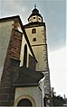
Former defense tower, tower of the dean's church

Entrance door to the former defense tower
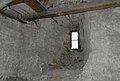
Loopholes in the Arnau fortified church tower

Scheme, as in the Arnau defense tower

Romanesque extension to the former defense tower


Colonist villages in the vicinity of the city: The fortified city of Arnau also attracted numerous colonists with their German settlers due to the high medieval eastern settlement.
- 1384 Hertwicivilla, colonist Hartwig
- 1254 Heinrichsau, Henrichowe, colonist Heinrich
- 1384 Goezierivilla, colonist Goez (Götz)
- 1384 Albertivilla, colonist Albert, Albendorf, Slezsku
- 1383 Vykerivilla, colonist Wickhart, Weiß-Trzemeschna, Bila Tremesna
- 1384 Hermannsdorph, colonist Hermann, Hermannseifen,
- 1384 Bernharticz cum Olessna (at Oels), colonist Bernhart
- 1383 Pertoldi villa, colonist Bernhart, Barteldorf, Slezska
- 1384 Kachwitz, 1399 Kothwicz, colonist from Kottwitz , Chotevice
Origin of the former German population
- Type of construction
Around Hostinné, the old Arnau, there are also Slavic place names, such as Prausnitz, Borowitz, Mastig, Öls, Tschermna and Proschwitz. These place names probably come from the Silesian region, there were many places with the same name. Numerous courtyards in these (Bohemian) villages show Franconian facilities . Usually 3 to 4 buildings close together around the courtyard to form a square, a true peasant castle. The old houses are at ground level and built in logs. The beams are usually painted dark brown, the joints smeared with clay are whitewashed. The high-barred roof used to be covered with shingles and thatch. The board wall of the gable field, richly decorated by the varied arrangement of boards, nailed-on strips and notch cuts, is divided into 2 to 3 parts that protrude one above the other in such a way that the topmost, covered by the hipped roof, protrudes the farthest.
- Names of the German population
The typical names of the mountain farmers were Adolf, Buchberger, Erlebach, Fischer, Goder, Kraus, Lahr, Renner and Zinnecker. The Hohenelber were Bittner, Ettel, Ettrich, Erben, Gottstein, Mähwald and Seidel, Langenauer names were Burkert, Graf and Schreier. Hermannseifner names were Fries, Drescher, Klug, Patzelt and Riedel. Kerner , Nagel, Purmann lived in Tschermna , Kuhn, Langner and Rummler lived in Kottwitz . In Arnau (1921) the old German names Gernert , Richter and others no longer prevailed due to significant immigration and emigration ( exiles ).
- Costumes
At the folk festivals one was dressed in oltfranksch , i. H. with a swivel or a Fohn (Schößenrock) of blue or brown cloth. Sleeve-sleeved Spenser or Maiker were also worn.
City structure
No districts are shown for the city of Hostinné. The settlement Dobrá Mysl ( Gutsmuts ) belongs to Hostinné .
Attractions
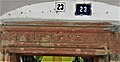
The square market square is surrounded by arcades. The houses with the arbors were built in the second half of the 15th and 16th centuries. In the late Gothic style , red Perm sandstone was installed on and in some of the town houses in the form of framing on portals and windows. The type of barbed windows and doors have been preserved very well thanks to the arbor superstructures. The pilasters contained in the framework with the turned and roughened bases occurring in the shaft are special .
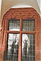
Late Gothic framing in the town hall arbor

Framework framing on a town hall door

Normelle for the cloth merchants in the town hall arbor

Frame detail in Hostinne


- Gothic door portals
Some door portals on the market have the Gothic digits of the year of construction in the door beam.

Inscription 1591 in the town hall

Boundary stone from 1547 in Dolni Brana 83
Inscription 1552 on E.-Votocka 23

Guild sign of the Fleischhauer Markt 71


- Gothic cellars
The cellar barrel vaults of the town houses have partly Romanesque and early Gothic entrances.

Gothic cellar corridors on the market

Gothic pointed arch door, basement corridor on the Elbe

Connecting corridor under the town hall

Early Gothic arch in the town hall cellar


- The Renaissance town hall was built on the previous building by C. Valmadis in 1570–1600. It was built of stone in the Gothic style in 1525. The tower, decorated with sgraffito , is adorned with two larger-than-life figures. Both carry a sword in one hand and a shield in the other: one with the Bohemian lion, the other with the Silesian eagle. The city coat of arms hangs between them. The cell vaults in the council rooms are special. The town hall cellar has Gothic arched portals from the 14th century and large barrel vaults that once housed the storage rooms for the councilors' wine and beer supplies.
- The plague column from 1678 in the middle of the square is decorated with statues of St. Antony of Padua, Francis of Assisi, John of Nepomuk, Sebastian and Ignatius.
- The Trinity Church ( Kostel Nejsvětějši Trojice ) was built in 1280 and redesigned several times. In 1877 it was regotized by Franz Schmoranz. The statue of the Madonna on the neo-Gothic altar dates from the 15th century, the richly decorated Renaissance pulpit is from 1612.
- The former Franciscan monastery and the monastery church were built between 1667 and 1689 according to plans by the Prague builder Martin Reiner. After his death in 1680, the facility was completed by his foreman at the time, Wolfgang Dientzenhofer .
- The city wall is only recognizable in fragments as the property wall of the northern town houses on the ring (market).
Twin town
Personalities
- Johann Franz Theer , linen dealer and beautician, Hermannseifen estate, Wildschütz, raised to the nobility in 1794
- Rudolf Materna (1883–1938), Austrian field marshal lieutenant
- Victor Lustig (1890–1947), con artist and impostor
- Rudolf Fahrner (1903–1988), German specialist in German
- Gerfried Schellberger (1918–2008), German painter and author
- Georg Stolle (1938–2020), German politician and mayor of Bensheim , honorary citizen of Hostinné (2019)
- See also: List of Mayors of Hostinné
literature
- Carl Leeder : Contributions to the history of Arnau . In: Communications from the Association for the History of Germans in Bohemia . Volume 11, Prague 1873, pp. 13-27 , pp. 41-61 and pp. 242-267.
- Marianne Mehling (Ed.): Knaur's cultural guide in color Czech Republic, Slovak Republic. Droemer Knaur, Munich 1993, ISBN 3-426-26609-1 .
- Joachim Bahlcke , Winfried Eberhard, Miloslav Polívka (eds.): Handbook of historical places . Volume: Bohemia and Moravia (= Kröner's pocket edition . Volume 329). Kröner, Stuttgart 1998, ISBN 3-520-32901-8 , p. 8 f.
- Otto Weiss, Volume 1 and 2, The old home, Arnau on the Elbe in the Riesengebirge, Heimatkreis Hohenelbe / Riesengebirge eV 11th volume of the local books, 87616 Marktoberstein, printing CZ 54101 Trutnov.
- Alfred Meißner u. Dr. Karl Schneider: The land on the high Elbe (Arnau and Hohenelbe), pamphlet of homeland education, issue 17, Sudetendeutscher Verlag Franz Kraus, Reichenberg 1921.
- Jan Šícha, Eva Habel, Peter Liebald, Gudrun Heissig: Odsun. The expulsion of the Sudeten Germans. Documentation on the causes, planning and realization of an "ethnic cleansing" in the middle of Europe in 1945/46. Sudeten German Archive, Munich 1995, ISBN 3-930626-08-X .
- Johann Gottfried Sommer: The Royal Bohemia, presented statistically and topographically, Bidschower Kreis, Arnau page 213 ff., Prague 1835 Verlag der JGCalve'sche Buchhandlung online
- Francisci Pubitscka: Chronological history of Bohemia, under the intermediate kings, and K. Karl IV., Part 5, Volume 1, Seien 70 ff. And 386, 522, Prague 1784 printed online by Karl Hraba
Web links
- Website of the city of Hostinné (Czech)
- Franciscan monastery (city museum, library, gallery) (Czech)
- Panorama of the market square
- Riesengebirgsheimat, 7th episode July 1955, page 7, Arnau - A tour through the city
- City map with cadastre and names of owners from the "Stable Cadastre 1841"
- Allodial rule Arnau together with the good Tschermna, pages 213 to 223 by Joh.Gottfried Sommer, Prague Calve`s bookstore 1835
Individual evidence
- ↑ Český statistický úřad - The population of the Czech municipalities as of January 1, 2019 (PDF; 7.4 MiB)
- ↑ Among the inter-kings, and K. Karl IVten: 5th part. Volume, Volume 5 , p. 70 XXX
- ^ Berent Schwineköper: Burgrave of Magdeburg (approx. 1300 Maidburg). In: Neue deutsche Biographie 15. 1987, accessed on May 2, 2020 .
- ^ Czerwenka: Splendor et gloria domus Waldsteiniana 1673.
- ↑ Dr. Carl Leeder: Contributions to the history of Arnau . Ed .: Communications of the Association for the History of Germans in Bohemia. 11th year, second and third booklet, p. 45, 46 .
- ^ Vinzenz Maiwald: The Braunauer Ländchen during the Husite era. In: Die Husitennot in Glatzer Lande (= Glatzer Heimatschriften. Vol. 30, ZDB -ID 2520906-1 ). Association for Glatzer Heimatkunde, Glatz 1928, pp. 63–68.
- ↑ Jan Urban: Lichtenburkové. Vzestupy a pády jednoho panského rodu (= Šlechtické rody Čech, Moravy a Slezska. 2). Nakladatelství Lidové Noviny, Praha 2003, ISBN 80-7106-579-X , pp. 321–322.
- ↑ ( Hotel Městský hotel a restaurace Dorinka )
- ↑ Georg Schmidt: A register on the wine trade 1579 . Ed .: Association of Germans in Bohemia. tape 47 , 1908, pp. 94 to 100 .
- ↑ Johann Gottfried Sommer : The Kingdom of Bohemia. Represented statistically and topographically. Volume 3: Bidschower Kreis. Calve, Prague 1835, pp. 213-223.
- ↑ Heribert Sturm : Lorenz v. Riesenstett. In: Heribert Sturm (Hrsg.): Biographical lexicon for the history of the Bohemian countries. Volume 2: I - M. Published on behalf of the Collegium Carolinum. R. Oldenbourg Verlag Munich 1984, ISBN 3-486-52551-4 , p. 499 ( page no longer available , search in web archives ) Info: The link was automatically marked as defective. Please check the link according to the instructions and then remove this notice. .
- ↑ The paper industry in the Hohenelbe district in the Bohemian Giant Mountains around 1907
- ^ Annual report of the state secondary school in Arnau . Arnau 1873, p. 35 ff.
- ↑ a b Meyer's Large Conversation Lexicon . 6th edition, Volume 1, Leipzig and Vienna 1905, p. 794.
- ^ Rudolf Hemmerle: Sudetenland Lexikon Volume 4, page 39. Adam Kraft Verlag, 1985. ISBN 3-8083-1163-0 .
- ↑ Michael Rademacher: German administrative history from the unification of the empire in 1871 to the reunification in 1990. Hohenelbe district (Czech. Vrchlabí). (Online material for the dissertation, Osnabrück 2006).
- ^ Rudolf M. Wlaschek: Jews in Böhmen . Munich: Oldenbourg, 1990, p. 151
- ↑ Topographic Lexicon of Bohemia . Prague 1852, p. 5.
- ^ A b Michael Rademacher: German administrative history from the unification of the empire in 1871 to the reunification in 1990. sud_hohenelbe.html # ew39helbarnau. (Online material for the dissertation, Osnabrück 2006).
- ↑ Karl Schneider. The history of the Germans of East Bohemia. 1. Volume From the earliest times to the beginning of the Hussite storms. Sudetendeutscher Verlag Franz Kraus, Reichenberg 1924 p. 81
- ↑ The old home, Arnau an der Elbe in the Riesengebirge by Dr. Otto Weiss Volume 1, Page 483
- ↑ The Johannesbader Sprudel considering its healing effects on the ... , p. 141
- ^ Johann Gottfried Sommer: The Kingdom of Bohemia presented statistically and topographically. Calve'sche Buchhandlung, Prague, 1835, p. 219. ( digitized version )
- ↑ Wacslaw Wlaiwoj Tomek: Registra Decimarum Papalium, (register of papal tithes of the people of Prague) . In: Treatise of the Classie for Philosophy, History, and Philology . tape 6 . Prague 1873.
- ↑ Alfred Meißner, Dr. Karl Schneider: Village, farm and tribal species around Arnau . Ed .: leaflet of homeland education. No. 17 . Franz Kraus, Reichenberg 1921.
- ↑ Rodolf Joh. Meraviglia-Crivellt: The Bohemian nobility . In: Reference work p. 94 v. Ther . Nicolaihofe 1885.
- ^ The mayor of Arnau from 1477 to 1945 . Trutnov / Archive Trautenau.