Choťovice
| Choťovice | ||||
|---|---|---|---|---|
|
||||
| Basic data | ||||
| State : |
|
|||
| Region : | Středočeský kraj | |||
| District : | Kolín | |||
| Area : | 905 ha | |||
| Geographic location : | 50 ° 8 ′ N , 15 ° 20 ′ E | |||
| Height: | 204 m nm | |||
| Residents : | 200 (Jan. 1, 2019) | |||
| Postal code : | 289 05 | |||
| License plate : | S. | |||
| traffic | ||||
| Street: | Žehuň - Žiželice | |||
| Railway connection: | Velký Osek – Trutnov | |||
| structure | ||||
| Status: | local community | |||
| Districts: | 1 | |||
| administration | ||||
| Mayor : | Josef Slavíček (as of 2008) | |||
| Address: | Choťovice 1 289 05 Žehuň |
|||
| Municipality number: | 534994 | |||
| Website : | ou-chotovice.vasoft.cz | |||
Choťovice (German Chotiowitz , also Chotowitz ) is a municipality in the Czech Republic. It is located 14 kilometers east of Poděbrady and belongs to the Okres Kolín .
geography
Choťovice is located on the left bank of the Žehuňský rybník pond fed by the Cidlina on the East Bohemian Table. The railway line Velký Osek – Trutnov runs on the opposite side of the pond , there is also the railway station "Choťovice". The hill Kozí hůra (272 m) rises to the southwest. In the south, the village is bypassed by the D 11 / Europastraße 67 motorway.
Neighboring towns are Dlouhopolsko , Na Kopičáku and Kněžičky in the north, Lovčice and Bludy in the Northeast, Převýšov , zbraň and Končice the east, Rozehnaly and Radovesnice II in the southeast, Dománovice in the south, Polní Chrčice in the southwest, Žehuň and Libněves the west and Hradčany and Stará Báň in the northwest.
history
According to ancient traditions, there was a Slavnikid festival in Choťovice . In 995, the Přemyslids, in league with the Vršovci, took advantage of the absence of the Slavnikid's army to conquer their territories. The Choťovice fortress is said to have been destroyed.
The first documentary mention of the place took place in 1357, when Mikuláš and Jan Bartek were named as owners of the fortress, which was probably built around 1345. Another owner from 1392 is Mikuláš von Chotějovice. In 1414 the Choťovice was attached to the rule Hradišťko. The layout of the place with its central market square 150 m long and 100 m wide, to which all streets lead, suggests that Choťovice was laid out as an urban settlement. After the Cidlina had been dammed up into the large Zehun fish pond in 1492, the place was right on the edge of the water and could no longer expand. In the berní rula of 1654 ten peasant positions, six sit-in and two kötter are shown for Choťovice.
After the abolition of patrimonial Chotějovice / Chotowitz formed a municipality in the Nový Bydžov district from 1850 . In 1870, the Groß Wossek - Wostromer railway line opened on the opposite bank of the lake at the Zehuner Tiergarten . In 1895 a four-class school opened in the town. At the end of the 19th century the name of the village changed first to Chotovice and then to Choťovice . In 1931 518 people lived in the village. On January 1, 1961, Choťovice was incorporated into Žehuň and at the same time came to Okres Nymburk. Since the beginning of 2007 it has belonged to the Okres Kolín.
Community structure
No districts are shown for the municipality of Choťovice. Choťovice to include monolayer Korce ( Koretz ).
Attractions

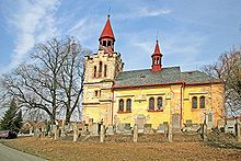
- Early baroque church of the Mariä Wiegenfest, the original building with a wooden bell tower, which can be traced back to 1357, was destroyed by a lightning strike in the 17th century. In 1670 it was rebuilt with a new design. In 1860, according to plans by the builder Míča, a reconstruction and the construction of a bell tower took place. In 1864 the church was consecrated in the presence of Agnes Countess Kinsky .
- Pond Žehuňský rybník ( Zehun Pond ) with 258 hectares of water surface, national nature reserve
- Nature reserve Kněžičky and forest Žehuňská obora ( Zehuner Tiergarten ), opposite the pond
- Chapel of St. Ferdinand, northeast on the edge of the Žehuňská obora
- Hunting lodge Kněžičky (new building) in Žehuňská obora


