Friendship cliff
The friendship cliff is one of the numerous resin cliffs of the Harz low mountain range . The rock formation is located near Mägdesprung in the Harz district of Saxony-Anhalt .
Geographical location
The friendship Cliff is located in the Lower Harz in the Harz / Saxony-Anhalt Nature Park - 2.7 km north-northwest of Harzgerode core local and 2.1 km north-northeast of Alexisbad , 300 m northeast of Stahlhammer and 500 meters southeast of Mägdesprung, three in Selketal down looking at the Selke located Harzgeroder districts. It is located on the northern part of the Schalkenburg elevation ( 400.1 m ) at about 350 m above sea level. NHN . To the north-northwest it is 150 m (as the crow flies ) to the Alexius Cross at the Mägdetrappe rock .
Protected areas
Parts of the Upper Selketal nature reserve ( CDDA no. 318891; designated 1998; 17.401 km² in size), the Harz landscape protection area and northern Harz foreland (CDDA no. 20784; 1968; 1587.6238 km²), the Fauna-Flora Habitat area Selketal and mountain meadows near Stiege (FFH no. 4332-302; 45.22 km²) and the bird sanctuary in the Northeast Lower Harz (VSG no. 4232-401; 169.88 km²).
Hiking and viewing opportunities
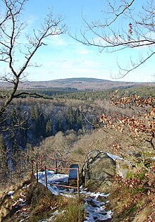
The Selketalstieg runs west of the Freundsklippe in the section from Alexisbad to Mägdesprung, from which the cliff can be reached via a short Firstweg. The viewpoint on the cliff is secured with a small railing and equipped with a bench. From here there is a view of the Selketal with the Selketalbahn and the neighboring mountains - including to the northwest to the Viktorshöhe ( 581.5 m ) in the Harz mountain range of Ramberg .
literature
- Axel and Volker Mothes: Harzer Klippen- & Stiegenwelt, Volume I , Stiegenbuchverlag Halle (Saale), 2011, p. 12.
Individual evidence
- ↑ Cliff elevation in meters (m) above sea level (NHN): Estimated value according to contour lines from map services of the Federal Agency for Nature Conservation ( information )
- ↑ Map services of the Federal Agency for Nature Conservation ( information )
Coordinates: 51 ° 39 ′ 56.9 ″ N , 11 ° 8 ′ 1.2 ″ E
