
Ramberg (Harz)
| Ramberg | ||
|---|---|---|
| height | 587.1 m above sea level NHN | |
| location | District of Harz , Saxony-Anhalt ( Germany ) | |
| Mountains | Harz (Eastern Harz) | |
| Coordinates | 51 ° 41 ′ 33 " N , 11 ° 3 ′ 30" E | |
|
||
| rock | granite | |

The Ramberg , also called the Ramberg massif , is a maximum of 587.1 m above sea level. NHN high and about 30 km² large granite massif of low mountain range Harz in Saxony-Anhalt Harz district .
Geographical location
The Ramberg stretches with several peaks in the Harz / Saxony-Anhalt Nature Park, for example between Thale in the north, Bad Suderode, Gernrode and Ballenstedt in the northeast, Harzgerode in the south and Friedrichsbrunn in the southwest. Its highest elevation is called Wegenerskopf ( 587.1 m ), slightly east-southeast of it is the Viktorshöhe ( 581.5 m ).
The Ramberg massif borders the Bode valley in the north-west (see also Bodetal ), and its outer south-east foothills meet a small section of the Selke with the Mansfelder Land on the other side . In the area of the massif, these rivers arise among others: Friedenstalbach , Krebsbach , Uhlenbach and Wurmbach . Its still waters include: Bergrat-Müller-Teich , Bremer Teich , Erichsburger Teich and Gondelteich .
Attractions
On the southwest flank of the Viktorshöhe are the Große Teufelsmühle and Kleine Teufelsmühle, two of which are said to be entwined granite rocks. In the wider area of the Ramberg are the bear monument and the Erichsberg castle ruins .
Transport links
The state road 239 between Friedrichsbrunn and Bad Suderode and the L 240 between Friedrichsbrunn and Thale run through the Ramberg massif. The federal road 185 runs south-east from Harzgerode via Mägdesprung to Ballenstedt .
gallery

Big devil's mill
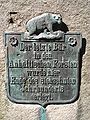
Bear memorial


Individual evidence
- ↑ Saxony-Anhalt viewer of the State Office for Surveying and Geoinformation ( notes )
- ↑ Map services of the Federal Agency for Nature Conservation ( information )
Web links
- The Ramberg , on harzlife.de