Viktorshöhe
| Viktorshöhe | ||
|---|---|---|
| height | 581.5 m above sea level NHN | |
| location | near Gernrode ; District of Harz , Saxony-Anhalt ( Germany ) | |
| Mountains | Harz ( Ramberg , Eastern Harz) | |
| Coordinates | 51 ° 41 '9 " N , 11 ° 4' 57" E | |
|
|
||
The Viktorshöhe is 581.5 m above sea level. NHN the second highest elevation of the Ramberg ridge , a massive granite in the Harz Mountains . It is located in the Gernrode district of the city of Quedlinburg in the Harz district of Saxony-Anhalt .
Geographical location
The Viktorshöhe, formerly Victorshöhe , rises in the Harz / Saxony-Anhalt Nature Park . Its summit is 5.5 km southwest of the Quedlinburg district of Gernrode, 3.2 km east of the village Friedrichsbrunn , a southern district of the city of Thale , and 3.7 km northwest of Mägdesprung , a district of the city of Harzgerode .
The Hagentalbach in the northeast, the Krebsbach in the south, the Friedenstalbach in the southwest and the Kaltetalbach in the northwest arise at or near the Viktorshöhe . About 1.5 km southwest of the summit of the elevation, which slopes slowly in this direction, lies the Bergrat-Müller-Teich on the Friedenstalbach with the Erichsburger Teich located a little below it . The Bremer Teich spreads out about 2 km east of the summit . The rock groups of the Große Teufelsmühle and Kleine Teufelsmühle are located on the southwest slope .
About 1.8 km west-northwest rises in the column moor nature reserve with the Wegenerskopf ( 587.1 m ), the highest point of the Ramberg massif.
History and Buildings
The first hunting lodge on the Viktorshöhe was built next to a well house at the instigation of Prince Viktor Friedrich in 1750. The first observation tower was built there in the 18th century. In 1892 a building on Viktorshöhe had developed into a popular restaurant for excursions. In 1897 a 20 m high tower was built from oak trunks, from which a view of the Kyffhäuser was possible. In 1927, the hitherto existing and with a was Schankrecht provided forestry dissolved. The last forester are Messrs Jacobi and Sachtler. However, the property was continued and expanded as a restaurant.
In 1946, the district president of Anhalt, Heinrich Deist senior, stayed at the Viktorshöhe inn. He witnessed a raid on the inn on the night of July 14, 1946, carried out by three Soviet soldiers. The owner of the Viktorshöhe was stabbed with a dagger in the back and hit with a revolver. 600 Reichsmarks , a radio and clothes were stolen from him. House guests were also robbed. Saalmann remained the Viktorshöhe innkeeper until 1958. In 1959 the Viktorshöhe became a company holiday home, although the restaurant remained open to the public.
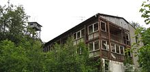
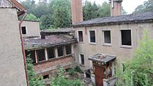
At the end of the 1970s, the building complex became a company holiday home for VEB Draht- und Seilwerke Rothenburg . The restaurant next to it was still a popular hiking and excursion destination. In 1990 the restaurant was closed. The buildings, which have been vacant since the early 1990s, have been falling into disrepair since then. The furnishings left behind are scattered around the area and offer a picture of vandalism and neglect.
Until it collapsed in November 2012, a wooden tower stood near the summit, which was used, among other things, as a fire watch tower and space for antennas for various radio services. In the 1980s, due to its good height, the tower was also used by radio amateurs of the then district contest team of the GDR district of Halle under the amateur radio call sign Y34H at numerous international amateur radio competitions. This tower was not built as an observation tower, but served as a place for a trigonometric high signal over a trigonometric point (TP) of the 1st order of the national survey and for this purpose as an observation tower . As in other federal states, this high-level signal lost its importance due to the progress of technology.
On the northeast flank of the Viktorshöhe there is a transmission tower near the summit , and the Ramberger Bear Monument on its southeast flank .
Individual evidence
- ↑ a b Map services of the Federal Agency for Nature Conservation ( information )
- ↑ Saxony-Anhalt viewer of the State Office for Surveying and Geoinformation ( notes )
- ^ Rosemarie and Gerhard Kellermann, Chronicle of the City of Gernrode , Gernroder Kulturverein Andreas Popperodt e. V. 2013, p. 38
- ↑ a b Rosemarie and Gerhard Kellermann, Chronicle of the City of Gernrode , Gernroder Kulturverein Andreas Popperodt e. V. 2013, p. 73
- ^ Rosemarie and Gerhard Kellermann, Chronicle of the City of Gernrode , Gernroder Kulturverein Andreas Popperodt e. V. 2013, p. 55
- ↑ a b Rosemarie and Gerhard Kellermann, Chronicle of the City of Gernrode , Gernroder Kulturverein Andreas Popperodt e. V. 2013, p. 61
- ^ Wilfried Lübeck: The cases are increasing - attacks by Soviet soldiers in Saxony-Anhalt 1945–1947 , Mitteldeutscher Verlag Halle (Saale), ISBN 978-3-89812-873-5 , page 146
- ^ Rosemarie and Gerhard Kellermann, Chronicle of the City of Gernrode , Gernroder Kulturverein Andreas Popperodt e. V. 2013, p. 68


