
Fuxing (Changhua)
|
Fuxing 福興 鄉 |
|||
.svg) Location of Fuxing in Changhua County |
|||
| State : |
|
||
| County : | Changhua | ||
| Coordinates : | 24 ° 2 ′ N , 120 ° 26 ′ E | ||
| Height : | 0 - 23.9 m | ||
| Area : | 49.8934 km² | ||
| Residents : | 46,615 (Apr. 2020) | ||
| Population density : | 934 inhabitants per km² | ||
| Time zone : | UTC + 8 (Chungyuan time) | ||
| Telephone code : | (+886) (0) 4 | ||
| Postal code : | 506 | ||
| ISO 3166-2 : | TW-CHA | ||
| Community type : | Rural community ( 鄉 , Xiang ) | ||
| Structure : | 22 villages ( 村 , Cūn ) | ||
| Website : | |||
|
|||

Fuxing ( Chinese 福興鄉 , Pinyin Fuxing Xiang ), sometimes fusing , is a rural municipality ( 鄉 , Xiang ) in Changhua County of Republic of China on Taiwan .
Location and climate
Fuxing is located on the west coast of the island of Taiwan and borders the Taiwan Strait . The east-west extension of the municipality is about 11.5 kilometers and the north-south extension varies between just under 2 and 7 kilometers. The neighboring communities are Lukang in the north, Xiushui in the west, Puyan and Erlin in the south (the latter only in a very short section), and Fangyuan in the southwest. Geologically, Fuxing consists mainly of alluvial land that was brought in by the rivers that flow into the Taiwan Strait. The terrain corresponds to a flat coastal plain with a maximum height of 23.9 meters. There is an altitude gradient from southeast to northwest. The largest rivers are the Dongluoxi ( 東 螺溪 , Dōngluó xī ) or Maiyucuoxi ( 麥 嶼 厝 溪 , Màiyǔcuò xī ), which flows from southwest to northeast in the west of Fuxing and represents the former main arm of the Zhuoshui ( 舊 濁水 溪 , Jiù zhuīósh - "old Zhuoshui River"), as well as the Ergang drainage ( 二 港 排水 , Èrgǎng páishuǐ ), a straightened and canalized river, which in the south-west forms the border to the neighboring municipality of Buyan for about 5 kilometers in the south-west.
The climate of Fuxing is hot and dry and corresponds to a subtropical monsoon climate . In winter it is characterized by the strong northeast monsoon.
history
The area was originally settled by members of the indigenous Taiwanese ethnic group ( Pingpu ) of the Babuza ( 巴布薩 族 , Bābùsàzú ). From the reign of Kangxi , settlers from Fujian (mostly from the Quanzhou and Xiamen area ) were recruited as land tenants. Due to the increasing hogging the country by the Han -Siedler most of the indigenous population migrated during the time Daoguangs further inland to the east. At the time of the Japanese rule (1895-1945) an administrative reform took place in 1920, and Fuxing was reorganized as a "village" ( 庄 , Zhuāng ) ( 福興 庄 , Fúxīng Zhuāng ). After the Republic of China took over Taiwan in 1945, the "village" became the "rural community" ( 鄉 , Xiang ) Fuxing, initially in Taichung County and from 1950 in the newly formed Changhua County.
population
At the end of 2019, 208 members of indigenous peoples lived in Fuxing, corresponding to a population share of 0.4%.
| Outline of Fuxing |
|
|

Administrative division
Since 1988 Fuxing has been divided into 22 villages ( 村 , Cūn ):
1 Sanbian ( 三 汴 村 )
2 Wanfeng ( 萬豐 村 )
3 Waizhong ( 外 中 村 )
4 Fanshe ( 番社 村 )
5 Yuanzhong ( 元 中 村 )
6 Waipu ( 外 埔村 )
7 Dalun ( 大 崙 村 )
8 Fanpo ( 番 婆 村 )
9 Qiaotou ( 橋頭 村 )
10 Shewei ( 社 尾村 )
11 Tong'an ( 同 安 村 )
12 Xishi ( 西 勢 村 )
13 Fuxing ( 福興 村 )
14 Funan ( 福南 村 )
15 Ergang ( 二 港 村 )
16 Fubao ( 福寶 村 )
17 Dingnian ( 頂 粘 村 )
18 Xianian ( 廈 粘 村 )
19 Xiucuo ( 秀 厝村 )
20 Zhenping ( 鎮 平 村 )
21 Sanhe ( 三 和村 )
22 Maicuo ( 麥 厝村 )
economy
Agriculture, dairy farming and fishing form the basis of Fuxing's economy . There are also some nationally important industrial companies, such as the Baocheng shoe factory, the Yuancheng oil seal rubber factory and many small manufacturers of hardware components. The industry is concentrated on the one hand in the village of Wanfeng and on the other along the coast. The fishing industry in the coastal zone is mainly based on the breeding of eels and mussels. The excessive use of the coastal area in the past has increasingly led to the salinisation of agricultural land. As a result, the area has increasingly become a habitat and breeding ground for sea birds. In order to compensate for the loss of agricultural land, the state subsidized dairy farming, which today makes up the largest part of Fuxing's agricultural production. Mostly watermelons and peanuts are grown near the coast , and further inland sweet potatoes , wet rice , peas and rapeseed . Other agricultural products are corn and asparagus . In earlier times, the Taiwanese government strove to assign a specialty agricultural product to each community, and for Fuxing this became the watermelon. A traditional but dying trade is the production of brooms from millet (?, 掃帚 草 - "broom grass").
traffic
Provincial road 61 runs essentially parallel to the coast through Fuxing, as does Provincial Road 17 further inland. In the center of Fuxing, county road 135 crosses the municipality. The district road 144 runs parallel to this and turns west in the north of Fuxing towards the coast. The district roads 142 (in the northeast) and 144 甲 (144A, in the southeast) run in an east-west direction.
particularities
One of the structural landmarks of Fuxing is the Fuxing Bridge ( 福興 橋 , Fúxìng qiáo ) over the Ergang drainage canal , a light blue painted arched bridge , which is also known as Bezeichnung 長虹 , Lán sè chánghóng - "long blue rainbow" . Another striking tied arch bridge painted in red, the Fuan Bridge ( 福安 橋 , Fú'ān qiáo ) can be found further up the canal on the border of the villages of Shewei and Tong'an. In the village of Fanpo there is an anti-aircraft tower ( ) from 1942, which was built by the Japanese military to protect the nearby Waipu airfield. On the coast, in the village of the same name, is the Fubao wetland ( 福寶 溼 地 , Fúbǎo shīdì ), a nature reserve known for its abundance of birds.
![]()
![]()
![]()
![]()
 Spectators at the Dragon Boat Festival 2015, the Fuxing Bridge on the left
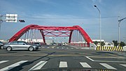 Fuan Bridge
 Former Japanese anti-aircraft tower


Web links
Individual evidence
- ↑ a b c 地名 與 歷史 沿革 ("Place name and history"). Fuxing website, accessed June 6, 2020 (Chinese (traditional)).
- ↑ 原住民 戶數 及 人數 Households and Persons of Indigenous People. (xls) Taiwan Ministry of the Interior, accessed May 14, 2020 (Chinese, English).
- ↑ 產業 概況 ("Industry overview"). Fuxing website, accessed June 6, 2020 (Chinese (traditional)).
- ↑ 交通 指引 (traffic regulation). Fuxing website, accessed June 6, 2020 (Chinese (traditional)).
- ↑ 福興 采風 導覽 (sightseeing tour). Fuxing website, accessed June 6, 2020 (Chinese (traditional)).