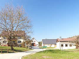
Görbitz (Hiltpoltstein)
|
Goerbitz
Hiltpoltstein market
Coordinates: 49 ° 38 ′ 58 " N , 11 ° 18 ′ 34" E
|
|
|---|---|
| Height : | 486 m above sea level NHN |
| Residents : | 25 (Jan. 2019) |
| Postal code : | 91355 |
| Area code : | 09192 |
|
The Hiltpoltstein district of Görbitz
|
|
Görbitz is a Franconian hamlet in the north-western part of the Pegnitz-Kuppenalb .
geography
The village is one of 12 districts of the Hiltpoltstein market in the southwestern part of Upper Franconia . It is located about one and a half kilometers southwest of the center of Hiltpoltstein and is at an altitude of 486 m above sea level. NHN .
history
The occurrence of the final syllable "-itz" in the place name Görbitz would actually indicate that the place was founded by Slavic settlers. However, this is not the case here, because in the first documentary mention of the hamlet in 1146, the hamlet is referred to as Gerwardsdorf , later also as Gerwarz and Gerbeigsdorf . The first name to be seen as Gerwards (village) shows the place as the village of a Gerward . This is a name that goes back to the combination of the two Germanic terms "Ger" = throwing spear (see frame ) and "waltan" = rule . So Görbitz is the genitive of a German personal name and the spurious "-itz" ending only appeared secondary. The use of this ending was probably based on real "-itz" locations in the large-scale area, such as Scheßlitz, which is about 45 kilometers north-northeast .
Towards the end of the Middle Ages, the place was owned by the for Kurpfalz belonging monastery Weißenohe . As a result of the territorial and legal changes that the Landshut War of Succession brought with it in this area, the hamlet was subject to the high jurisdiction of the Nuremberg nursing authority Hiltpoltstein with certain restrictions (such as the right of first access in criminal cases) from the beginning of the 16th century . The bailiwick of the two only properties in the village continued to hold the Weißenohe monastery, which thus acquired village and community rulership and thus also sovereignty over the village. In essence, nothing changed when the Upper Palatinate was handed over as a fief to Kurbaiern after the ostracism of the Palatinate Elector Friedrich V (the so-called Winter King ) . For Görbitz this only meant that the sovereignty over the place was now taken over by another Wittelsbach line .
Due to the administrative reforms carried out in the Kingdom of Bavaria at the beginning of the 19th century , Görbitz became part of the rural community Hiltpoltstein with the second municipal edict in 1818, to which the hamlet of Göring also belonged in addition to this parish village . In the period that followed, Görbitz shared the fate of the Hiltpoltstein community, which was expanded by a further nine districts as part of the municipal territorial reform carried out in Bavaria in the 1970s . In 2019 Görbitz had 25 inhabitants.
traffic
The connection to the public road network is made by a municipal road that branches off about 800 meters east-northeast of the town from the state road St 2241 and continues from Görbitz via Wölfersdorf to Lilling about two kilometers to the southwest , where it joins the district road FO 22 .
literature
- Ingomar Bog: Forchheim . In: Historical Atlas of Bavaria . Commission for Bavarian State History, Munich 1955.
- Gertrud Diepolder : Bavarian History Atlas . Ed .: Max Spindler . Bayerischer Schulbuch Verlag, Munich 1969, ISBN 3-7627-0723-5 .
- Herbert Maas: Mausgesees and ox thighs. Small north Bavarian place-name studies . 3. Edition. Verlag Nürnberger Presse, Nuremberg 1995, ISBN 3-920701-94-1 .
Web links
- Bavarian authorities guide for Görbitz , accessed on May 15, 2019
- Görbitz in the BayernAtlas , accessed on May 15, 2019
- Görbitz on a historical map , accessed on May 15, 2019
Individual evidence
- ↑ a b Population of Görbitz , accessed on May 15, 2019
- ^ Görbitz in the local database of the Bayerische Landesbibliothek Online . Bavarian State Library, accessed on May 15, 2019.
- ↑ Geographical location of Görbitz in the BayernAtlas , accessed on May 15, 2019
- ↑ Herbert Maas: mouse Gesees and ox leg. Small north Bavarian place-name studies . S. 87 .
- ↑ Herbert Maas: mouse Gesees and ox leg. Small north Bavarian place-name studies . S. 84 .
- ↑ Herbert Maas: mouse Gesees and ox leg. Small north Bavarian place-name studies . S. 207 .
- ↑ Gertrud Diepolder : Bavarian History Atlas . Ed .: Max Spindler . Bayerischer Schulbuch Verlag, Munich 1969, ISBN 3-7627-0723-5 , p. 25 .
- ^ Ingomar Bog: Forchheim . S. 21 .
- ^ Ingomar Bog: Forchheim . S. 54 .
- ↑ Gertrud Diepolder : Bavarian History Atlas . Ed .: Max Spindler . Bayerischer Schulbuch Verlag, Munich 1969, ISBN 3-7627-0723-5 , p. 98-99 .
- ^ Ingomar Bog: Forchheim . S. 19 .
- ^ Ingomar Bog: Forchheim . S. 118 .
- ^ Federal Statistical Office (ed.): Historical municipality directory for the Federal Republic of Germany. Name, border and key number changes in municipalities, counties and administrative districts from May 27, 1970 to December 31, 1982 . W. Kohlhammer, Stuttgart / Mainz 1983, ISBN 3-17-003263-1 , p. 684 .

