
Wolfersdorf
| coat of arms | Germany map | |
|---|---|---|

|
Coordinates: 48 ° 29 ' N , 11 ° 43' E |
|
| Basic data | ||
| State : | Bavaria | |
| Administrative region : | Upper Bavaria | |
| County : | Freising | |
| Management Community : | Zolling | |
| Height : | 502 m above sea level NHN | |
| Area : | 26.05 km 2 | |
| Residents: | 2602 (Dec. 31, 2019) | |
| Population density : | 100 inhabitants per km 2 | |
| Postal code : | 85395 | |
| Area code : | 08168 | |
| License plate : | FS | |
| Community key : | 09 1 78 156 | |
| LOCODE : | DE WFF | |
| Community structure: | 16 parts of the community | |
| Address of the municipal administration: |
Ringstrasse 12 85395 Wolfersdorf |
|
| Website : | ||
| First Mayor: | Anita Wölfle | |
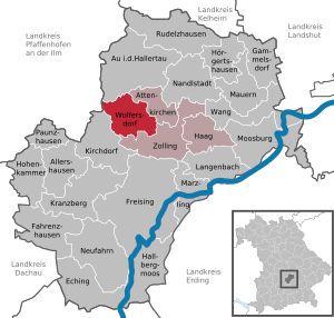
| Location of the community Wolfersdorf in the Freising district | ||
  |
||

Wolfersdorf is a municipality in the Upper Bavarian district of Freising and a member of the Zolling administrative community .
geography
The community is located north of the Ampertal in the Hallertau hill country.
The municipality has 16 officially named municipality parts (the type of settlement is indicated in brackets ):
|
|
history

Until the 19th century
The first documentary mention is around the year 948, the districts of Badendorf and Berghaselbach are mentioned as early as 748. Wolfersdorf was the seat of an open Hofmark and belonged to the Landshut Rent Office and the Moosburg Regional Court . The local aristocratic family of Wolfersdorf can be traced back to the 14th and first third of the 15th century as owners of Hofmark Wolfersdorf. Later the Counts of Lodron auf Wolfersdorf (1778 to 1830) owned the Hofmark. In the course of the administrative reforms in Bavaria in 1818, the place became an independent political municipality with a second class patrimonial court . Wolfersdorf Castle was demolished in 1834. The last remnants of feudal rule were abolished in 1848.
Incorporations
As part of the municipal reform , the previously independent municipalities Berghaselbach on January 1, 1977 and Dürnhaindlfing on May 1, 1978 were incorporated into the Wolfersdorf municipality.
Population development
Between 1988 and 2018 the municipality grew from 1,595 to 2,600 by 1,005 inhabitants or 63%.
coat of arms
The gold coat of arms shows a green hop tendril with a leaf and three hop umbels, in front of which a red-armored black wolf leaping up. The wolf goes back to the seal of Wilhelm von Wolffersdorff (* around 1340; † 1403). The three hop cones indicate the hop cultivation in the community and the three formerly independent communities Berghaselbach , Dürnhaindlfing and Wolfersdorf.
Architectural monuments
Personalities
Honorary citizen
- Bruno Ehler (born July 5, 1913), doctor, appointed 1982
Sons and daughters of the church
- Helmut Eckl (* 1947), dialect poet and satirist
Personalities related to Wolfersdorf
- Philipp Held (1911–1993), lawyer and politician (CSU), Bavarian Minister of Justice from 1966 to 1974, died here.
Web links
- Entry on the Wolfersdorf coat of arms in the database of the House of Bavarian History
Individual evidence
- ↑ "Data 2" sheet, Statistical Report A1200C 202041 Population of the municipalities, districts and administrative districts 1st quarter 2020 (population based on the 2011 census) ( help ).
- ↑ Mayoral elections VG Zolling 2020. VG Zolling, accessed on May 17, 2020 .
- ^ Community Wolfersdorf in the local database of the Bavarian State Library Online . Bavarian State Library, accessed on September 11, 2019.
- ^ Federal Statistical Office (ed.): Historical municipality directory for the Federal Republic of Germany. Name, border and key number changes in municipalities, counties and administrative districts from May 27, 1970 to December 31, 1982 . W. Kohlhammer, Stuttgart / Mainz 1983, ISBN 3-17-003263-1 , p. 575 .
- ^ Widmann, Adolf: Chronicle of Wolfersdorf. Ed .: Wolfersdorf community, Au id Hallertau: Butt, 1983

Allershausen | Attenkirchen | Au in the Hallertau | Eching | Fahrenzhausen | Freising | Gammelsdorf | Hague an der Amper | Hallbergmoos | Hohenkammer | Hörgertshausen | Kirchdorf an der Amper | Kranzberg | Langenbach | Marzling | Walls | Moosburg on the Isar | Nandlstadt | Neufahrn near Freising | Paunzhausen | Rudelzhausen | Wang | Wolfersdorf | Zolling