
Geinegge
| Geinegge | ||
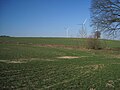
 The Geinegge on Klostermühlenweg |
||
| Data | ||
| Water code | DE : 278712 | |
| location | North Rhine-Westphalia , Germany | |
| River system | Rhine | |
| Drain over | Lippe → Rhine → North Sea | |
| source | Roggenberg between Ascheberg and Hamm 51 ° 43 ′ 6 ″ N , 7 ° 43 ′ 5 ″ E |
|
| Source height | approx. 86 m above sea level NN | |
| muzzle | Via the Radbodsee into the Lippe Coordinates: 51 ° 40 ′ 55 ″ N , 7 ° 46 ′ 30 ″ E 51 ° 40 ′ 55 ″ N , 7 ° 46 ′ 30 ″ E |
|
| Mouth height | approx. 55 m above sea level NN | |
| Height difference | approx. 31 m | |
| Bottom slope | approx. 3.3 ‰ | |
| length | 9.4 km | |
| Catchment area | 26.629 km² | |
| Left tributaries | Hölterbach, Mesenbach | |
The Geinegge forms a right-hand tributary of the Lippe as a stream or a small river . It is located in the Bockum-Hövel district of the city of Hamm .
Surname
The villages of Bockum and Hövel, from which today's Hammer district of Bockum-Hövel arose, once belonged to the tribal duchy of Saxony and were settled by Saxony . The name "Geinegge" comes from the Saxon. There the word ending “… egge” indicates swamp, moor or the like. Earlier spellings are “Gheneighe”, “Gynegge”, “Geneghe”, “Gyneghe”, “Genegge”, “Geneege” or “Geinhegge”. You probably describe a (s) "water (run) between hedges".
source
The Geinegge arises as a small hill country river in the border area of the municipality Ascheberg and the city of Hamm , more precisely at the foot of rye mountain on the border of belonging to Ascheberg peasantry Nordick and belonging to Hamm or Bockum peasantry Barsen the Hof Schulze-Krutmann in the northwest of the city Hamm. Its source, which was only discovered in 1928 by the Sauerland Mountain Association and has been a popular destination ever since, is 83.65 meters above sea level . The gradient to the Radbodsee , into which it flows at 55 meters above sea level, is 28.65 meters.
In addition, there are five other source streams that form the source system of the Geinegge. Their sources are only partially located in the Hammer area, rather they are near the city limits in the Warendorf district and in the Coesfeld district .
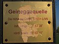
Information sign at the Geinegge spring.
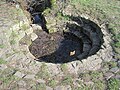
Geineggequelle.
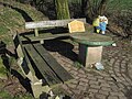
Seating area at the Geinegge spring.
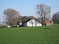
Schulze-Krutmann farm.


Rye mountain.

Rye mountain.
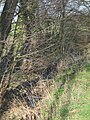
Geinegge behind the Geinegge spring.


Length and catchment area
In the older literature the length of the Geinegge is given as 8.5 kilometers. The course of the Geinegge was partly artificially changed; In the course of the land consolidation at the end of the 1970s, the Geinegge was almost completely straightened, partially piped and relocated, whereby the original course was filled. This presumably results in the deviating length specification of 9.411 kilometers on TIM-online. The catchment area of the Geinegge reaches a size of 26.6 km 2 . Three quarters of this is arable land (77.4%), followed by urban areas (6%) and forest (5.7%).
Course and function

The Geinegge crosses a large part of the rural area north of the Bockum-Hövel district, the Barsen, Hölter and Geinegge farmers. It initially flows several kilometers in an easterly direction and then turns south. On this way it touches the former cloister courtyard and the moats, moats and ponds of Haus Ermelinghof . The fish ponds are fed by the Mesenbach, which no longer flows freely into the Geinegge, but the overflow is discharged into the Geinegge at kilometers 3.0 and 3.2. Until about 1955, the castle mill located on Ermelinghof, which was demolished in 1978, was operated with their help. The lower course of the Geinegge flows through about 1.2 km of heavily populated area. Finally, the Geinegge crosses under the Bockumer Weg just east of the Römerstraße intersection and flows into the Radbodsee near the Römerstraße.
At 27 km 2 , the Geinegge catchment area is the largest in Hamm north of the Lippe main flood. The Geinegge can therefore already be regarded as a small river, even if, as a Tiefenlandbach with a predominantly straight course, it is also of stream quality.
As a result of the renovation work, the Geinegge is almost entirely provided with bank reinforcement. It is used to carry away drainage water from the arable land and for the safe discharge of summer and winter floods. It protects against flooding and is used to reclaim the floodplain. The improvement of the adjacent fields and "easy-care" profiles and embankments have also been implemented with the help of the Geinegge through water-hostile water development and maintenance measures . Since the Geinegge is located in a settlement area with residential buildings, farms, crop farming, traffic routes, bridges, etc. ä, the flood safety specified by the city of Hamm must not be worsened, even in the event of rescheduling.
Obstacles to patency and flow behavior are the 50 meter long piping parallel to the road "Im Barkerfeld" at kilometer 5.0, the weir south of Ermelinghof Castle at kilometer 3.0, the flow of the Förstersee at kilometer 2.2, the flow of the Radbodsee at kilometer 0.5 and the pumping station in the Lippe at kilometer 0.0.
Despite many anthropogenic influences that endanger the goal of good water status, the Geinegge has to be considered a natural surface water.
muzzle

The Geinegge first flowed into the Lippe, near the historic Nienbrügge Castle . Later it ended in the severed lip arm, the so-called "old lip". Finally, in the course of the embankment of the Lippe, it was diverted into the Radbodsee , which was used as a water reservoir until the Radbod colliery was closed.
Due to subsidence, the Radbodsee is now much deeper than the Lippe; The underground coal mining by the Radbod colliery caused the Alte Lippe and the adjacent lake area to sink by several meters. For this reason and because of the embankment of the Lippe, the water from the streams that flow into the Radbodsee, including the inflow from the Geinegge, must be conveyed and pumped up into the Lippe with the help of a pumping station 121.773 kilometers from the mouth of the Lippe.
Planned renaturation

The European Water Framework Directive has led to considerations to renature the Geinegge. In order to implement the Water Framework Directive, the state of North Rhine-Westphalia has decided on various programs of measures, taking into account the Geinegge, in addition to a management plan that is binding on the authorities. The planned measure is in two parts.
On the one hand, the Geinegge is to be renatured on a 500 meter long section between the Wiggert forest and the "Geinegge" road. To do this, they want to remove the massive stone embankments and change the course of the Geinegge by meanders (loops of water) and pools . In addition, the riverside path is to be relocated at this point in order to enable natural development of the water on the eastern side . The land required for this has already been purchased by the city of Hamm. According to the Hammer city administration, the properties on the western side of the Geinegge are not affected. The construction costs for this measure are estimated at 80,000 euros. 90% of this will be borne by the state of North Rhine-Westphalia .
On the other hand, the Geinegge is to be connected directly to the Lippe again. The framework directive on water law provides for a good ecological and chemical status to be achieved and maintained for all bodies of water so that bodies of water can once again become lifelines for nature. However, the pumping station at the end of the Geinegge forms an obstacle to migration for migratory fish species, aquatic plants and small organisms in the Geinegge. In addition, it causes operating costs. A feasibility study prepared by an external engineering office is to look for ways to freely connect the Geinegge to the Lippe. Geinegge and Radbodsee should no longer influence each other afterwards. However, the interests of the Radbodsee are taken into account. For example, the question arises whether the decoupling of the Geinegge will reduce the nutrient supply to the Radbodsee. The study should also provide information on boundary conditions and restrictions and estimate the costs of the construction project. The study itself will cost 35,000 euros, 90% of which will be borne by the state. The Bockum-Hövel district council expressed the fear that the relocation of Lake Radbodsee to a natural bed would lead to the entire area around Lake Radbodsee "sinking". The environmental agency of the city of Hamm does not see such a danger. The Geinegge should flow into the Lippe on the eastern, not the western, side of the Roman road. There is still a natural gradient here, so the difference in altitude between Lippe and the lower Radbodsee does not play a role. Against this background, the district council also approved a feasibility study.
The planned intervention is made more difficult by the fact that the Radbodsee is a nature reserve.
River landscape


North Rhine-Westphalia lies in the transition from the North German lowlands to the low mountain range threshold . The Geinegge can be clearly assigned to the lowlands, whereby the Geinegge touches all four water landscapes of the Westphalian lowlands: the source area and source stream lie in a small sandy area, followed by a section characterized by loess, followed by a weathered area in the central part and the lip lowlands in the south.
Hydrography
The Geinegge is a tributary of the Lippe, but it also has a number of tributaries. The largest include:
- Hölterbach , dry in summer, problematic water balance, catchment area: 7.66 km 2
- Mesenbach , dry in summer, problematic water balance, catchment area: 4.81 km 2
- Graben am Kötterberg, catchment area: 3.04 km 2
- Nameless body of water, catchment area: 1.42 km 2
- Barsener Graben, catchment area: 0.93 km 2
- Depe Becke, catchment area: 0.74 km 2
- Rehbach, discharges from various small sewage treatment plants, rain relief from the mixed water sewer system, "dirtiest hammer receiving water", catchment area: 0.35 km 2
Geinegge Castle and Aquack Knight's Seat
The Geinegge Castle , which has not survived, and the von Geinegge family of knights who used to live there, are named after the Geinegge. At the time Geinegge Castle was built, the stream must have carried more water than it does today, because written sources show an extraordinary fish population that no longer exists there today.
The even older knight's seat Aquack , owned by the independent farmers, was also located on the Geinegge.
Together with the monastery courtyard, the Ermelinghof and the Nienbrügge Castle, all noble houses in Bockum-Hövel were accessible through the Geinegge, with the exception of Hövel Castle and Laake .
Others
The Geinegge hiking trail planned by the former town of Bockum-Hövel was laid out by today's town of Hamm.
Bones of an Ice Age mammoth and a woolly rhinoceros have been found in the bed of the Geinegge .
See also
literature
- Willi Schroeder, Ein Heimatbuch. Two districts introduce themselves. Bockum and Hövel , 1980.
- Fritz Schumacher, Hartmut Greilich, Bockum-Hövel. From history and local history , Hamm 1956, new edition 2002.
Individual evidence
- ↑ a b c Topographical Information Management, Cologne District Government, Department GEObasis NRW ( information )
- ↑ Hans Bahlow, Germany's world of geographical names: Etymological Lexicon of River and Place Names of Old European Origin , Frankfurt a. M.: Klostermann, 1965.
- ↑ a b c d e f g Creation of an action plan to improve the water quality. Final report on the R&D project. November 2002 (PDF; 3.0 MB)
- ↑ cf. for example Schumacher, Bockum-Hövel. From history and local history from 1958.
- ↑ Reporting by the Westfälischer Anzeiger from August 24, 2010. ( Page no longer available , search in web archives ) Info: The link was automatically marked as defective. Please check the link according to the instructions and then remove this notice.
- ↑ Reporting by the Westfälischer Anzeiger from September 28, 2010. ( Page no longer available , search in web archives ) Info: The link was automatically marked as defective. Please check the link according to the instructions and then remove this notice.