Gil García
| Gil García parish | ||
|---|---|---|
| coat of arms | Map of Spain | |
 Help on coat of arms |
|
|
| Basic data | ||
| Autonomous Community : | Castile and Leon | |
| Province : | Ávila | |
| Coordinates | 40 ° 18 ′ N , 5 ° 36 ′ W | |
| Height : | 1145 msnm | |
| Area : | 15.0 km² | |
| Residents : | 35 (Jan. 1, 2019) | |
| Population density : | 2.33 inhabitants / km² | |
| Postal code : | 5693 | |
| Municipality number ( INE ): | 05085 | |
| administration | ||
| Official language : | Castilian | |
| Mayor : | Pedro Miguel García Sánchez ( PP ) | |
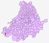
| Location of the municipality | ||

|
||
Gil García is a Spanish municipality in the province of Avila in the autonomous region of Castile and León .
geography
Gil García is located in the Sierra de Gredos , north of the border with Extremadura , at 1145 m above sea level. The place is known for its view of the north face of the Sierra de Gredos.
climate
There is a continental climate with mild summers.
politics
Gil García is politically assigned to the municipality of El Barco de Ávila and belongs to the judicial district of Piedrahita.
economy
The place is characterized by animal husbandry . The Tourism plays a minor role.
Attractions
- Romanesque church
Events
- January 20th: San Sebastian
- August 20: Big dance and folk festival
Individual evidence
- ↑ Cifras oficiales de población resultantes de la revisión del Padrón municipal a 1 de enero . Population statistics from the Instituto Nacional de Estadística (population update).
