
Gmina Krośniewice
| Gmina Krośniewice | |||
|---|---|---|---|

|
|
||
| Basic data | |||
| State : | Poland | ||
| Voivodeship : | Łódź | ||
| Powiat : | Kutnowski | ||
| Geographic location : | 52 ° 15 ′ N , 19 ° 10 ′ E | ||
| Residents : | s. Gmina | ||
| Postal code : | 99-340 | ||
| Telephone code : | (+48) 24 | ||
| Economy and Transport | |||
| Street : | Łódź - Toruń | ||
| Warsaw - Poznan | |||
| Rail route : | Kutno – Konin | ||
| Next international airport : | Łódź Airport | ||
| Gmina | |||
| Gminatype: | Urban-and-rural parish | ||
| Gmina structure: | 22 school authorities | ||
| Surface: | 94.71 km² | ||
| Residents: | 8387 (Jun. 30, 2019) |
||
| Population density : | 89 inhabitants / km² | ||
| Community number ( GUS ): | 1002043 | ||
| Administration (as of 2018) | |||
| Mayoress : | Katarzyna Erdman | ||
| Address: | ul.Poznańska 5 99-340 Krośniewice |
||
| Website : | krosniewice.pl | ||

The Gmina Krośniewice [ krɔɕɲɛˈvʲitsɛ ] is an urban-and-rural municipality in the powiat Kutnowski of the Łódź Voivodeship in Poland . Its seat is the city of the same name with about 4350 inhabitants.
geography
_location_map.png)
The municipality is located in the north of the voivodeship and borders in the west with the rural municipality of Chodów in the Greater Poland Voivodeship . The other neighboring municipalities are: Daszyna , Dąbrowice , Kutno and Nowe Ostrowy . The district town of Kutno is five kilometers to the east, the city of Łódź about 50 kilometers to the south.
The community has an area of 94.7 km², 89 percent of which is used economically, only three percent are forest.
history
The community was formed in 1973. It belonged to the then Powiat Kutnowski until 1975 and from 1975 to 1998 to the modern Płock Voivodeship , which only existed at that time.
structure
The town-and-country municipality (gmina miejsko-wiejska) Krośniewice with 8387 inhabitants (as of June 30, 2019) consists of the town itself and 22 villages with school boards (sołectwa). These are:
- Bielice ( 1943–1945 Raudenhof ),
- Franki ( 1943–1945 Frankdorf ),
- Jankowice,
- Kayev,
- Kopy,
- Luboradz,
- Morawce,
- Nowe,
- Ostałów,
- Pawlikowice,
- Pomarzany,
- Suchodoły,
- Szubina,
- Szubsk Duży,
- Szubsk Towarzystwo,
- Teresin,
- Witów,
- Wola Nowska,
- Wychny,
- Wymysłów,
- Zalesie,
- Objectives
The municipality includes the six settlements Osiedle 1–6 as well as the smaller villages: Bardzinek, Błonie, Cudniki, Cygany, Głaznów, Głogowa, Godzięby, Górki Miłońskie, Iwiczna, Kopyta, Krzewie, Marynin, Miłonice, Miłowankowice, Raszy , Rozpacz, Skłóty, Stara Wieś, Stare Morawce, Tumidaj and Zosin.
Listed sights

- Manor house and park in Bielice (20th century)
- Manor house, wall, gate and park in Głogowa (19th century)
- Church, bell tower, gate and cemetery in Krośniewice, built between 1872 and 1878
- Palace with orangery, guardroom and park in Krośniewice (19th century)
- Inn and coach house in Krośniewice, built in 1803; now a museum
- House at Kutnowska 2 in Krośniewice (19th century)
- Installation of the narrow-gauge railway in Krośniewice, built 1910–1915
- Manor house in Miłonice (18th century); Moved to Gniezno in 2010
- Windmill in Miłonice (19th century); departed
- Church and bell tower in Nowe (1775)
- Manor and park in Skłóty (1888/20 th century)
- Manor house and park in Szubsk-Towarzystwo (19th century)
- Manor house, outbuildings and park in Teresin-Głaznów (19th century)

Manor house in Bielice
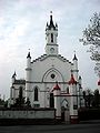
Church in Krośniewice

Castle in Krośniewice
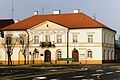
Inn in Krośniewice


.jpg)

traffic
Łódź is the nearest international airport. The national roads DK91 and DK92 cross in the city . The Krzewie railway station and the Nowe Kutnowskie stop on the Warszawa – Poznań railway line are in the municipality .
The narrow-gauge Ostrowy – Ozorków railway used to cross the line at Krzewie . The narrow- gauge railway to Boniewo also ended at the Krośniewice Miasto narrow-gauge railway station in the city .
Personalities
- Władysław Anders (1892–1970), General and Commander in Chief of the Polish Armed Forces in the West; born in the settlement of Błonie near Krośniewice.
Web links
- City and municipality website (Polish)
Individual evidence
- ↑ population. Size and Structure by Territorial Division. As of June 30, 2019. Główny Urząd Statystyczny (GUS) (PDF files; 0.99 MiB), accessed December 24, 2019 .
- ↑ a b regioset.pl: data on the municipality (Polish, accessed on March 21, 2020)
- ↑ krosniewice.pl: Sołtysi i sołectwa . (Polish, accessed March 21, 2020)
- ↑ a b Source: German Army Map, Europe 1: 300 000, Q 52 Litzmannstadt, Issue No. 3, Print XII 1944, Slide D / 414
- ↑ Registered in the list of monuments of the Łódź Voivodeship under the number 471 on November 14, 1978.
- ↑ NID : Informational directory of the list of monuments of the Łódź Voivodeship (as of March 31, 2016) (PDF, 500kB; Polish, accessed on March 23, 2020) pp. 9–11.