
Gmina Pajęczno
| Gmina Pajęczno | |||
|---|---|---|---|

|
|
||
| Basic data | |||
| State : | Poland | ||
| Voivodeship : | Łódź | ||
| Powiat : | Pajęczański | ||
| Geographic location : | 51 ° 9 ′ N , 19 ° 0 ′ E | ||
| Residents : | s. Gmina | ||
| Postal code : | 98-330 | ||
| Telephone code : | (+48) 34 | ||
| License plate : | EPJ | ||
| Economy and Transport | |||
| Street : | Radomsko - Wieluń | ||
| Next international airport : | Katowice | ||
| Gmina | |||
| Gminatype: | Urban-and-rural parish | ||
| Gmina structure: | 19 school authorities | ||
| Surface: | 113.0 km² | ||
| Residents: | 11,562 (Jun. 30, 2019) |
||
| Population density : | 102 inhabitants / km² | ||
| Community number ( GUS ): | 1009043 | ||
| Administration (as of 2018) | |||
| Mayor : | Piotr Mielczarek | ||
| Address: | ul. Parkowa 8/12 98-330 Pajęczno |
||
| Website : | www.pajeczno.pl | ||

The Gmina Pajęczno [ pa'jɛntʃnɔ ] is an urban-and-rural municipality in the powiat Pajęczański of the Łódź Voivodeship in Poland . The seat of the Powiat and the municipality is the city of the same name with about 6700 inhabitants.
geography
_location_map.png)
The municipality is located in the south of the voivodeship and borders there on the Gmina Popów in the Silesian Voivodeship . The Warta forms part of the border . The city of Częstochowa is about 30 kilometers south. The other neighboring municipalities in Łódź Voivodeship are: Działoszyn , Kiełczygłów , Nowa Brzeźnica , Rząśnia , Siemkowice , Strzelce Wielkie and Sulmierzyce .
The community has an area of 113.0 km², 61 percent of which is used for agriculture and 28 percent for forestry.
history
The community was formed in 1975 from the urban and rural parishes. Pajęczno had been the seat of a powiat since 1956 and was granted city rights in 1958 . In 1975 the powiat was dissolved and the community came to the Częstochowa Voivodeship by the end of 1998 . After its dissolution, Pajęczno was again the seat of the powiat and part of the Łódź Voivodeship.
structure
The town-and-country municipality (gmina miejsko-wiejska) Pajęczno with 11,562 inhabitants (as of June 30, 2019) consists of the town itself and 21 villages with 19 school boards (sołectwa). These are:
- Czerkiesy
- Dylów A with Tuszyn
- Dylów Rządowy
- Dylów Szlachecki
- Janki
- Kurzna with Barany
- Lipina ( 1943–1945 Lindenau )
- Ładzin
- Łężce
- Makowiska ( 1943–1945 Markwiese )
- Niwiska Dolne
- Niwiska Górne ( 1943–1945 Grenzflur )
- Nowe Gajęcice
- Patrzyków
- Podmurowaniec
- Siedlec
- Stare Gajęcice
- Wręczyca
- Wydrzynów
Smaller villages in the municipality are Grabiec, Podładzin and Sierociniec. Colonies are Czerkiesy, Short Miasto, Majorat; in addition, there are the forest settlements Gajęcice-Gajówka, Patrzyków and Wistka.
Listed sights
- Parish church in Pajęczno, built 1748–1753
- Pajęczno cemetery (19th century)
- House at 41/43 Kościuszki Street in Pajęczno (19th century)
- Windmill in Pajęczno (19th century); probably gone
- Makowiska cemetery (older part)
The:
- Parish church in Makowiska with a free-standing bell carrier.

Parish Church in Pajęczno
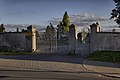
Pajęczno cemetery
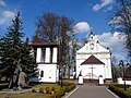
Parish Church in Makowiska


traffic
The national road DK42 runs through the municipality and its main town from Radomsko in the east to Wieluń in the west. The Katowice Airport is closer than the Łódź .
The nearest station is the Biała Pajęczańska station in Biała (Biała Szlachecka) on the Wyczerpy – Chorzew Siemkowice railway line , which has not been used for passenger traffic since 2012 .
Web links
- City and municipality website (Polish)
Individual evidence
- ↑ population. Size and Structure by Territorial Division. As of June 30, 2019. Główny Urząd Statystyczny (GUS) (PDF files; 0.99 MiB), accessed December 24, 2019 .
- ↑ a b c regioset.pl: data on the municipality (Polish, accessed on March 22, 2020)
- ↑ a b c Großblatt 106 Welun – Rosenberg OS – Czestochowa (XI. 1944)
- ↑ NID : Informational directory of the list of monuments of the Łódź Voivodeship (as of March 31, 2016) (PDF, 500kB; Polish, accessed on March 23, 2020) pp. 60–61.
- ↑ Registered in the list of monuments of the Łódź Voivodeship under the numbers 10/29 (June 15, 1946) 219/78 and 249/67 (August 30, 1967).
- ↑ Registered in the list of monuments of the Łódź Voivodeship under the number A / 499/89 on November 12, 1989.
- ↑ Registered in the list of monuments of the Łódź Voivodeship under the numbers 211/78 and 649/67 on August 31, 1967.
- ↑ Registered in the list of monuments of the Łódź Voivodeship under the numbers 724-XVI-2 (November 6, 1956) and 250 (August 30, 1967).
- ↑ Registered in the list of monuments of the Łódź Voivodeship under the number A / 502/89 on November 21, 1989.