Gračišće
| Gračišće | ||
|
||
|
|
||
| Basic data | ||
|---|---|---|
| State : |
|
|
| County : |
|
|
| Height : | 457 m. i. J. | |
| Area : | 61 km² | |
| Residents : | 1,419 (2011) | |
| Population density : | 23 inhabitants per km² | |
| Telephone code : | (+385) 052 | |
| Postal code : | 52402 | |
| License plate : | PU | |
| Structure and administration (status: 2013, cf. ) |
||
| Community type : | local community | |
| Mayor : | Ivan Mijandrušić ( IDS / DDI ) | |
| Website : | ||
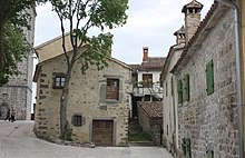
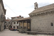
Gračišće (Italian Gallignana ) is a city and a municipality in Istria ( Croatia ). According to the 2011 census, the number of inhabitants of the municipality is 1,419, with 466 living in Gračišće itself. Gračišće is completely a listed building.
geography
Gračišće is located 8 kilometers east of Pazin on the Pazin - Kršan - Vozilići road .
history
Gračišće was first mentioned in a document in 1199.
trail
On the western outskirts of Gračišće, the red and white marked "St. Simon's Trail" begins to various interesting points in the area, e.g. B. to the waterfall "Sopot", which is one of the most beautiful waterfalls in Istria. In spring there is an extraordinarily rich orchid flora to be seen along the route.
Villages in the municipality
According to the 2011 census:
- Batlug (127 inhabitants)
- Bazgalji (245 inhabitants)
- Gračišće (466 inhabitants)
- Jakačići (143 inhabitants)
- Mandalenčići (291 inhabitants)
- Milotski Breg (93 inhabitants)
- Škopljak (54 inhabitants)
Web links
Commons : Gračišće - collection of images, videos and audio files


