
Grímsvötn
| Grímsvötn | ||
|---|---|---|
 Grímsvötn with Grímsfjall Mountain in 1972 |
||
| height | 1725 m | |
| location | Iceland | |
| Mountains | Vatnajökull , Grímsfjall | |
| Coordinates | 64 ° 24 ′ 30 ″ N , 17 ° 20 ′ 15 ″ W | |
|
||
| Type | Subglacial volcano | |
| Last eruption | May 2011 | |
| particularities | subglacial lakes | |
 Eruption cloud at the beginning of the eruption on May 22, 2011 |
||


.jpg)

Grímsvötn [ 'g̥rimsvœʰtn̥ ] (Isl. "Grímurs Lakes") is the name of a volcano and a subglacial lake , which are hidden in the Icelandic highlands in the southeast of Iceland under the approximately 8300 km² glacier shield of the Vatnajökull glacier . There are several large volcanic centers, Bárðarbunga and Grímsvötn are the most important of them.
Surname
Both the lakes and the volcano derive their name from a folk legend.
According to this, a man named Grímur, who came from the Westfjords (hence his nickname Vestfjarða Grímur ) , had settled near the ice-free lakes . However, he had a relationship with the daughter of Trolls, who when she was angry with him, gave him a curse one day: the lakes where he lived were supposed to spew fire at certain times and the surrounding forests burned down - a Curse that was abundantly fulfilled.
volcano
It is a subglacial central volcano , the system of which has had the highest eruption frequency since the settlement of Iceland.
In the edge of the main caldera of the central volcano is the mountain Grímsfjall , which forms the highest point of the central volcano with a height of 1725 m . The central volcano consists of various intertwined and mostly ice-filled calderas and a subglacial lake in the main caldera.
Grímsvötn volcanic system
The Gjálp volcano also belongs to the Grímsvötn volcanic system , which attracted attention in 1996 with a large glacier run . According to Magnús Tumi Guðmundsson , Þórðarhyrna is also included .
The crater row of Laki is according to recent research on this volcanic system counted.
Volcanic activity
General
The Grímsvötn volcano is one of the most active volcanoes in Iceland. About 60 eruptions of the volcano have been known since Iceland was settled in the 9th century. During the last 100 years, Grímsvötn has erupted on average about every 10 years: 1910, 1922, 1933, 1934, 1938, 1954, 1983, 1986, 1996, 1998, 2004 and 2011. Further eruptions will occur in 1919, 1939, 1941, 1948 , 1972 and 1984 suspected.
A large part of the approximately 60 known eruptions of the Grímsvötn volcano from the last 800 years took place in short fissures within the main caldera.
It was not until 1934 that the first eruption could actually be observed up close, although in previous centuries, of course, one had noticed ash fall and seen the eruption column from a distance. But the volcano is about 50 km from the inhabited area in the middle of the Vatnajökull glacier, i. H. in a hard-to-reach place.
The location of the craters that have formed since then has only been known since the 1930s. The eruption sites from 1934, 1983 and 1998 are all roughly at the same point, namely on the edge of the caldera below western Svíahnjúkur and below the north side of Grímsfjall . The northern flank of the mountain rises steeply about 200 to 300 m above the ice sheet, which in turn covers the glacial lake below. The mountain flank consists entirely of palagonite and at the same time forms the southern edge of the main caldera of Grímsvötn. All of the cracks known so far lay parallel to the edge of the caldera.
However, the site of the 2004 eruption is in a different location, namely in the southwest of the glacial lake, about 2 km further west. It is likely that some of the craters from the eruptions in the 19th century were located around this point.
Individual eruption phases
Until the 17th century
The proven history of the eruptions of the Grímsvötn volcano begins about 8230 years ago with a strong explosive eruption (VEI6).
The famous, mainly effusive eruption of the Laki crater in the 18th century also had predecessors in the area. A similar eruption of unknown magnitude has been documented about 4,500 years ago.
Further prehistoric eruptions about 3500 and 2000 years ago and around the year 50 AD could be detected.
Since the time when Iceland was settled in the 10th century, the volcano initially erupted about 2 to 3 times every century. From the 17th century the frequency of outbreaks increased significantly, but more recent outbreaks can also be more easily detected, e.g. a. because tephra and lava layers are not so much overlaid by other layers.
18th century
With the eruption of the Laki craters in 1783 and 1784, the volcanic system produced one of the most devastating disasters in Icelandic history. During the eruption, 12 to 14 km³ of lavas covered large parts of the south of Iceland. At the same time, poisonous gases and clouds of ash were also emitted, which contained a high proportion of sulfur dioxide and fluorine . A fifth of the population died of direct and indirect consequences such as the famine resulting from the poisoning of pastures, streams and rivers and the subsequent death of cattle.
In other countries too, the aerosol clouds caused crop failures.
1996: eruption in Gjálp and glacier run over Skeiðarársandur
The eruption of the later so-called Gjálp volcano in 1996 had been announced days before by a series of earthquakes and a cloud of smoke and ash. The enormous amounts of meltwater flowed off under the ice and collected in the subglacial lake Grímsvötn, causing the water level to rise sharply and finally the ice barrier in front of it to be broken. The rivers Skeiðará and Gígjukvísl in particular started to run glaciers , with 45,000 m³ / s falling into the valley at the culmination point of the flood and flooding the sand in front of the Skaftafell National Park .
The ring road ( Hringvegur ) had been closed days before. It was severely damaged in places by the floods and the carried icebergs - some of which were up to 10 m high and weighed several tons - and one bridge was completely destroyed.
The eruption in Gjálp also triggered a small eruption in the neighboring volcano Bárðarbunga on November 6th , which only lasted briefly, but produced a 4 km high eruption column.
1998: Eruption in the Grímsvötn
From December 18 to 28, 1998, a volcanic eruption occurred in Grímsvötn. The eruption sites were located along a 1300 m long fissure with east-west orientation near the eruption sites of 1934 and 1983. At the beginning of the explosive eruption, the eruption column reached a height of 10 km.
Since this time, in contrast to the eruption in Gjálp 10 km further north in 1996, no large amounts of ice melted, there was no major glacier run .
2004: Outbreak in the Grímsvötn
On November 1, 2004, the volcano erupted again, throwing a 13 km high ash cloud into the atmosphere . No people were injured, as the volcano is surrounded and covered by huge ice masses in the uninhabited southeastern highlands of Iceland. Air traffic was widely diverted around the ash cloud. Researchers suspect that the reason for the eruption was the increasing pressure in the magma chamber under the Vatnajökull glacier , which led to the rock layers breaking up and an explosive eruption . On the other hand, this time no major glacier run was triggered because no real ice barrier had built up since the last eruption, the water was not dammed and could gradually drain away.
2010: Grímsvötn glacier run with no detectable eruption
Since October 31, 2010 , a steadily increasing amount of water has been measured , especially in the Gígjukvísl river , which flows out of the Skeiðarárjökull valley glacier . Some of the river's water comes from the glaciated lakes Grímsvötn. In addition, an increased electrical conductivity of the water was measured, which suggests a proportion of hot deep water.
The course of the glacier at the measuring station on Gígjukvísl had a water flow of 455 m³ / s on November 1, 2010, and on November 2, 2010 it had already risen to around 1650 m³ / s.
At the same time, stronger earthquakes up to a strength of 3 on the Richter scale were measured at the measuring station on Grímsfjall , which is part of the caldera of the Grímsvötn volcano.
Geologists from the University of Iceland's Volcanological Institute also noted a sudden increase in volcanic tremor at the same measuring station on the morning of November 3, 2010 . These could have been signs of an impending outbreak.
The geologists therefore undertook a surveillance flight over the glacier on November 3, 2010 and discovered that the glacier surface had sunk in some places over the Grímsvötn. On the other hand, on the evening of November 3, 2010, there were no signs of a volcanic eruption that could have broken through the surface of the glacier. With a water volume of 2600 m 3 / s and thus 600 m 3 / s more than at the eruption of 2004, the glacier run had reached its peak according to the scientists at that time. However, conductivity in the Gígjukvísl and Súla rivers was still high.
On November 5, 2010, the scientists gave the final all-clear: it was only water that had been thawed continuously by the high-temperature area of the Grímsvötn and had accumulated in the lakes. The glacier run has since subsided. However, compared to previous such events, he had changed his direction of travel. H. By far the largest amount of water flows this time over the river Gígjukvísl on the western Skeiðarársandur and not, as before, mostly over the river Skeiðará further east .
2011: Outbreak in the Grímsvötn


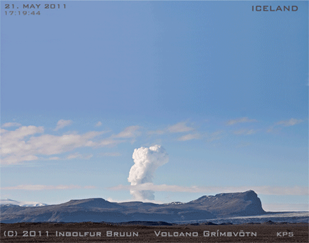
On May 21, 2011 at 5:30 p.m., another eruption of the volcano began. An ash cloud rose up to 5500 m into the atmosphere and the eruption was accompanied by around 50 earthquakes up to magnitude 3.8.
One day later the ash cloud reached a height of at times 19 km, but in contrast to the eruption of the Eyjafjallajökull volcano in the previous year , it consisted primarily of water vapor, which was created when the glacier melted. Ash particles were only found up to a height of about 7 km. The airspace was closed within a radius of 200 km, as volcanic ash poses a significant risk to air traffic .
The volcanic eruption on May 22, 2011 was fairly steady and produced an eruption column of mostly 9 to 10 km, rarely up to 15 km in height. The eruption is still stronger than that of Eyjafjallajökull in 2010, although it has subsided somewhat. Magnús Tumi Guðmundsson , Professor of Geophysics at the Volcanological Institute of the University of Iceland , estimated the amount of eruption material emitted at 10,000 to 20,000 t / s in the initial phase. At the time of the interview with the Icelandic state television broadcaster RUV, he suspected that it was still 1000 to 2000 t / s, which is more than when the Eyjafjallajökull erupted in 2010 in its most active phase. The eruptions of the Grímsvötn volcano are known for the fact that they can last for a long time, but the strong ash fall only reaches into inhabited areas in the first few days. The material ejected is mainly basalt rock . Noticeably many lightning bolts, i. H. 300 pieces were found in the eruption cloud between 5 and 6 p.m. on May 22nd.
On May 22nd there was also considerable ash rain in a limited area that stretched from Öræfajökull to Kirkjubæjarklaustur . The Hringvegur was therefore temporarily closed between Vík í Mýrdal and Freysnes near Skaftafell .
On May 23, the eruption cloud reached a height of 8 to 10 km, later only to a height of 5 to 9 km, although one had to take into account the strong storm at the place of the eruption that blew the cloud away. The main part of the cloud was driven south, but there was an easterly wind at heights above 8 km, with a smaller part blowing west.
There was heavy ash fall throughout the day from Vík í Mýrdal to Öræfasveit district . 9.4 g / m 2 was measured in Kirkjubæjarklaustur . The fluorine content was 9.4 mg / kg. The slightly basic pH value of 8.6 indicates that the magma is broken down into its components during phreatomagmatic eruptions , similar to what is known from other eruptions of the Grímsvötn volcano.
The eruption site is in the main caldera of the Grímsvötn and at the same place as in 2004, namely in the southwest corner of the caldera.
The GPS station on Mount Grímsfjall moved a lot during the first phase of the eruption. On the first two days, this moved 50 cm to the northwest and lowered by 25 cm.
On May 24, 2011, the force of the eruption had weakened in all respects. The now mostly light gray to white eruption cloud only reached heights of 5 to 8 km; only about 10 to 70 t / s of eruption materials were emitted; the tremor was mostly even, a little stronger in between; No earthquakes were measured directly at the eruption site, only a few of minor magnitude in the south and south-west. There was still ash fall in the south and south-west, but this too did not reach the intensity of the last few days by far, but the ash cloud now moved about 800 km south out to sea. With regard to the likely influence on European airspace, the ESA reassured : Since most of the ash was injected into very high parts of the atmosphere, there is no reason to fear such an extensive negative impact on aviation as in 2010 when the Eyjafjallajökull erupted . However, on May 24th, around 500 flights in northern Europe, i.e. H. in Scotland and Scandinavia, relocated or deleted because of the ash cloud. On May 25, the airports in Bremen, Hamburg, Berlin and some other cities were closed for a few hours. However, it soon turned out that there were only a few ash particles in the air, so that, for example, the Berlin airports were reopened long before the planned opening. It became known that the ash concentration is significantly lower than initially assumed.
Overall, the force of the outbreak continued to decline on May 25, 2011.
The eruption cloud had sunk to 5 km on May 24 at around 8 p.m., but rose again to 7 km during the night and briefly reached a height of 12 km again at around 2 a.m. After that, it could only be recognized for a short time on radar. Tephra fallout was only detectable near the outbreak site. Every time the eruption column had risen again and the now mostly light-colored one had turned darker again, a few lightning bolts could be detected in it.
Scientists and witnesses stated on site that there was still explosive eruption activity in the Grímsvötn, which was now concentrated in three to four eruption craters made of tephra in the middle of meltwater. In an interview with RÚV on May 25, 2011, the geophysicist and volcanologist Magnús Tumi Guðmundsson from the University of Iceland once again confirmed that a glacier run like the one in 1996 would not be expected this time. But it would be precisely on that. a. also this time the very large amount of ashes excreted, which can be roughly equated with that of the Katla eruption of 1918. This time the volcano didn't have to melt away so much ice.
On May 26, 2011 there were few changes compared to the previous day, smaller explosions continued to take place in the crater, but the ash fall only affected the immediate vicinity of the eruption site. On May 26, explosions were also observed at the edge of the cauldron, which lay on an eruption crevice that extended east from the previous craters.
According to an interview by the Icelandic national television broadcaster RÚV with the aforementioned scientist MT Guðmundsson, the volcanic eruption was fading on May 27, 2011, if it was still going on. It was not possible to determine this precisely due to the lack of an excursion to the site of the eruption.
On Saturday, May 28, 2011, the outbreak ended around 7 a.m. As for the result, Magnús Tumi Guðmundsson once again stated that as much material was extracted in one day as on 39 days of eruption of Eyjafjallajökull in 2010.
Typical breakouts at the moment
The volcano currently erupts about every 10 years.
Smaller eruptions occurred z. B. 1983 and 1998, each about 0.1 km 3 tephra was produced, the larger eruption of 1996 occurred on Gjálp , which is counted as part of the same volcanic system.
Grímsvötn eruptions currently always begin with a striking series of earthquakes that last for a few hours.
The thickness of the ice under the northern flank of Grímsfjall, i.e. H. at the mostly active breakout points, it is 50 to 200 m.
A beginning eruption can break through this ice cover very quickly, for example the eruption in 1998; the breakthrough can take half an hour to a full hour (see 2004).
These are always explosive, or more precisely phreatomagmatic, eruptions, with the basic magma being torn into fine-grained tephra products under the influence of the water.
The eruption column can reach a height of 10 to 14 km and the ashes can be spread all over the country; however, their total amount has been rather small in recent years.
The amount of material ejected from the last two eruptions was around 40 to 60 million m 3 in 1998 and 20 to 25 million m 3 in 2004. For comparison, the material ejected from the Eyjafjallajökull eruption in spring 2010 was at least 150 Million m 3 . The latter was not a major outbreak, it just lasted longer.
During the first two days, the force in the Grímsvötn eruptions can be considerable. 1998 and similar 2004 z. B. the magma upflow on the first day of the eruption was 150 to 200 m 3 / s or 500 t / s. That equates to the Tephra production of Eyjafjallajökull on the first four days in April 2010.
The eruption of the Grímsvötn unfolds most of its power in the first two days. However, it then subsides - unlike the eruption of Eyjafjallajökull. The total duration is usually one to two weeks, but there have been longer and shorter outbreaks. The strongest ash fall is limited to the first two days.
lake
General
It is a subglacial lake 100 to 200 m deep under an ice cover, usually about the same thickness, which fills the main caldera of the active Grímsvötn volcano (6 km × 8 km). It is located about 50 km north of Skaftafell .
This lake remains underground because of the geothermal heat source and never completely freezes over.
Every 5 to 10 years the water level rises due to volcanic activity to such an extent that the lake empties and sends tidal waves as a so-called glacier run over the upstream sander plains .
microbiology
In the summer of 2004, bacteria were discovered in Lake Grímsvötn . These are the first bacteria ever to be found in an overglacial lake.
See also
- Volcanoes in Iceland
- Geography of Iceland
- List of mountains and elevations in Iceland
- List of lakes in Iceland
literature
- Hjörleifur Guttormsson, Oddur Sigurðson: Leyndardómur Vatnajökuls. Viðerni, fjöll and byggðir. Stórbrotin náttúra, eldgos og jökulhlaup. Reykjavík (Fjöll og firnindi) 1997 ISBN 9979-60-325-9
- Scientific literature list (in English): Vulkanolog. Inst., Univ. Iceland
Web links
Photos and videos
Eruption in Gjálp in 1996
- Photo and video of the eruption in Gjálp with subsequent glacier run over Skeiðarársandur 1996, text in Icelandic
- Film Það er ei nema eldur og ís ( Eng . There is nothing but fire and ice ): Film about volcanism in Iceland, especially Gjálp / Grímsvötn 1996 and Kraflaeldur 1975-84, video with Icelandic commentary
Eruption in 2004 in Grímsvötn
Outbreak 2011
- Photos of the 2011 eruption, website of the University of Iceland's Volcanological Institute
- More pictures of the eruption, English language website of the Meteorological Inst., Iceland
- Satellite images, maps, schematic drawings, website of the Vulkanolog. Inst., Univ. Iceland
- Image series; Vísir.is (text: Icelandic); Accessed May 24, 2011
- RÚV.is (Icelandic): Link to video at the bottom of the page (Video = isl. Myndband): Grímsvötn outbreak in the midnight sun, 24./25. May 2011
- NASA image June 11, 2011
- Photo sequence: beginning of the eruption in May 2011, seen from Skeiðarársandur
Scientific contributions
General
- Grímsvötn in the Global Volcanism Program of the Smithsonian Institution (English)
- Icelandic Meteorological Office: current earthquake measurements at Vatnajökull (English)
- Institute of Earth Sciences, Nordic Volcanological Center, Univ. of Iceland: Grímsvötn (Geol. description of the Grímsvötn and the last eruptions) (English)
Various individual aspects
- Raimon Alfaro, Bryndís Brandsdóttir, Daniel P. Rowlands, Robert S. White, Magnús T. Gudmundsson: Structure of the Grímsvötn central volcano under the Vatnajökull icecap, Iceland , Geophysical Journal International , Volume 168, Issue 2, 863-876, February 2007 , doi : 10.1111 / j.1365-246X.2006.03238.x (abstract, English)
- F. Albino et al. a .: Influence of surface load variations on eruption likelihood: application to two Icelandic subglacial volcanoes, Grímsvötn and Katla. Univ. Iceland 2010, doi : 10.1111 / j.1365-246X.2010.04603.x (on the connection between snow and ice cover on the one hand and the probability of eruption on the other) (English)
- K. Scharrer: Monitoring ice-volcano interactions using SAR and other remote sensing techniques. (Diss.) Faculty of Geosciences at the Ludwig Maximilian University of Munich, 2007 (satellite observations of volcanoes under Vatnajökull) PDF file (English)
- E. Magnússon, H. Björnsson, H. Rott, and F. Pálsson: Reduced glacier sliding caused by persistent drainage from a subglacial lake. The Cryosphere , 4, 13-20, 2010, doi : 10.5194 / tc-4-13-2010
- Berthier, ea: The level of the Grímsvötn subglacial lake, Vatnajökull, Iceland, monitored with SPOPT5 images , Science Direct, Earth and Planetary Science Letters 243 (2006) 293–302 (PDF file, English; 588 kB)
- Grímsvötn eruption 21 May to 28 May 2011 , IN: Tephrabase. A Tephrochoronological Database , Univ. of Edinburgh
2004 eruption
Outbreak 2011
- Satellites monitor Icelandic ash plume (ESA satellite observation of the eruption, especially in relation to the spread of ash clouds )
- John A. Stevenson: Grímsvötn 1 - Crossing the glacier , Blog Volcan01010 , August 17, 2011 (3-part) report by the British geologist John A. Stevenson on his blog about a geolog. Excursion to the Grímsvötn after the 2011 eruption, in English, with photos
Other
Individual evidence
- ↑ www.ruv.is RÚV.is: Hver var Grímur? RÚV, fréttir, May 30, 2011 (Icelandic); Accessed May 30, 2011.
- ↑ Magnús T. Gudmundsson, Thórdís Högnadóttir: Volcanic systems and calderas in the Vatnajökull region, central Iceland: Constraints on crustal structure from gravity data , Journal of Geodynamics , Vol. 43, iss. 1, Jan. 2007, 153-169; doi : 10.1016 / j.jog2006.09.015
- ↑ See Grímsvötn in the Global Volcanism Program of the Smithsonian Institution (English).
- ↑ Ari Trausti Guðmundsson: Living Earth. Facets of the geology of Iceland. Reykjavík 2007, p. 197.
- ↑ a b See also www.volcano.si.edu Global Volcanism Program, Smithsonian Inst .: Grímsvötn. Eruptive history. Accessed May 28, 2011.
- ↑ After: Magnús T. Guðmundsson: Grímsvatnagos - Yfirlit. Háskóli Íslands. www.jardvis.hi.is ; Accessed November 15, 2010.
- ↑ a b c d www.volcano.si.edu Grímsvötn, Eruptive History IN: Global Volcanism Program, Smithsonian Inst .; Accessed August 8, 2010.
- ↑ a b c cf. earthice.hi.is Univ. Iceland: Geol. Description of the Grímsvötn (English).
- ↑ See e.g. B. http://volcano.oregonstate.edu/vwdocs/volc_images/europe_west_asia/laki.html ; Accessed August 8, 2010.
- ↑ a b Cf. Vulkanolog. Inst., Univ. Iceland, To the eruption in Gjalp ; Accessed March 27, 2011 (English).
- ↑ See www.mbl.is Morgunblaðið, November 10, 1996; Accessed August 8, 2010.
- ^ Institute of Earth Sciences, Univ. of Iceland (English); Accessed September 8, 2011
- ↑ DLR: Sciamachy on Envisat - eruption of the volcano Grimsvotn in Iceland ; Accessed September 27, 2010.
- ↑ See earthice.hi.is Vulkanolog. Inst., Univ. Iceland; Accessed July 24, 2010.
- ↑ http://en.vedur.is/about-imo/news/2010/nr/2039 Veðurstofan, d. H. Icelandic Meteorological Institute (English); Accessed November 3, 2010.
- ↑ vedur.is Isl. Meteorolog. Inst. (Icelandic); Accessed November 3, 2010.
- ↑ See www.ruv.is website of the Icelandic State Broadcasting Corporation RUV (Icelandic); Accessed November 3, 2010.
- ↑ hraun.vedur.is tremor data of the isl. meteorol. Inst. Am Grímsfjall, accessed on November 3, 2010.
- ↑ See also: www.spiegel.de Access: November 3, 2010 Axel Bojanowski : Volcano in Iceland threatens to erupt . in: Der Spiegel Online .
- ↑ [1] Joint daily report (Isl .: Minnisblað) of the Icelandic Meteorological Office and the Department of Volcanology at the Háskóli Íslands from November 3, 2010, 5 pm (Icelandic); (PDF file; 39 kB) Accessed November 4, 2010.
- ↑ en.vedur.is Isl. Meteorolog. Office, Accessed November 6, 2010.
- ↑ www.vedur.is Meteorolog. Inst., Iceland (Icelandic); Accessed May 22, 2011.
- ↑ Volcano erupts in Iceland, spurs 50 quakes. Retrieved May 21, 2011 .
- ↑ a b Volcanic eruption in Iceland ( Memento from May 23, 2011 in the Internet Archive ), tagesschau.de from May 22, 2011.
- ↑ Magnús Tumi Guðmundsson, Professor of Geophysics at the Volcanological Institute of the University of Iceland, on May 22, 2011 in an interview with the Icelandic state television broadcaster RUV ; Accessed May 22, 2011.
- ↑ a b Grímsvötn - Staða 23 May 2011, class 17.00. Minnisblað frá Veðurstofu Íslands og Jarðvísindastofnun Háskólans. (Vulkanolog. Inst., Univ. Iceland and Meteorolog. Inst. Islands, joint daily report on the volcanic eruption in Grímsvötn (5 pm local time)) [PDF file] (Icelandic); Accessed May 23, 2011.
- ↑ Overview map of the Isl. Road Watch; Accessed May 22, 2011.
- ↑ Grímsvötn - Staða May 24, 2011, class 16.00. Minnisblaðfrá Veðurstofu Íslands og Jarðvísindastofnun Háskólans. (Joint daily report Meteorolog. Inst. Iceland and Vulkanolog. Inst., Univ. Iceland from May 24, 2011, 4 pm local time) (Icelandic; PDF; 42 kB); Accessed May 24, 2011.
- ↑ Satellites monitor Icelandic ash plume (ESA satellite observation of the eruption, especially in relation to the spread of ash clouds) (English); Accessed May 24, 2011.
- ↑ Thousands hit by volcanic ash cloud flight delays , BBC (English); Accessed May 24, 2011.
- ↑ Weather experts expect the airspace to be closed ( memento from August 25, 2011 in the Internet Archive ), Tagesschau from May 24, 2011
- ↑ Grímsvötn no longer spits ashes - German air spaces open ( page can no longer be accessed , search in web archives ) Info: The link was automatically marked as defective. Please check the link according to the instructions and then remove this notice. , Hamburger Abendblatt; Accessed May 25, 2011.
- ↑ Harmless clouds: ash from the Icelandic volcano was probably not dangerous , in research on Deutschlandfunk, May 25, 2011.
- ↑ Grímsvötn volcano. Status report: 16:00 GMT 25 May 2011. , Icelandic Meteorological Office and Institute of Earth Sciences, University of Iceland [PDF file] (English); Accessed May 25, 2011.
- ↑ Video Gos í Grímsvötnum. , RÚV, May 25, 2011 (Icelandic); Accessed May 26, 2011.
- ↑ Grímsvötn volcano. Status report: 16:00 GMT 26 May 2011. , Icelandic Meteorological Office and Institute of Earth Sciences, University of Iceland [PDF file] (English); Accessed May 27, 2011.
- ^ Sjónvarpsfréttir. , RÚV, May 26, 2011 (Icelandic); Accessed May 27, 2011.
- ↑ Gos í andarslitrunum. , RÚV, May 27, 2011, 12:36 GMT (Icelandic); Accessed May 27, 2011.
- ↑ Jarðskjálftamælum, athugunum frá Grímsfjalli. (PDF file, Icelandic; 28 kB); Accessed May 30, 2011.
- ↑ Ísland er okkar stóra tilraunastofa , Förstudagsviðtalið, Fréttablaðið, May 27, 2011
- ↑ After: Magnús T. Guðmundsson: Grímsvatnagos - Yfirlit. Háskóli Íslands. [2] Accessed November 15, 2010.
- ↑ Ari Trausti Guðmundsson: Living Earth. Facets of the geology of Iceland. Reykjavík 2007, p. 197.
- ↑ Grímsvötn in the Global Volcanism Program of the Smithsonian Institution (English)
- ↑ Glacial lake hides bacteria.