
Groń (Bukowina Tatrzańska)
| Groń | |||
|---|---|---|---|
 Help on coat of arms |
|
||
| Basic data | |||
| State : | Poland | ||
| Voivodeship : | Lesser Poland | ||
| Powiat : | Tatrzański | ||
| Gmina : | Bukowina Tatrzańska | ||
| Geographic location : | 49 ° 23 ' N , 20 ° 4' E | ||
| Residents : | 1850 | ||
| Telephone code : | (+48) 18 | ||
| License plate : | KTT | ||
| Economy and Transport | |||
| Street : | State road 49 | ||
| Next international airport : | Krakow-Balice | ||

Groń is a village in the rural municipality of Bukowina Tatrzańska in the powiat Tatrzański in the Lesser Poland Voivodeship in southern Poland in the historical Podhale region . It is located on the Leśnica mountain stream . The village is located in the Pogórze Bukowińskie mountain range about two kilometers north of Bukowina Tatrzańska and about twelve kilometers northeast of Zakopane . It is a ski resort at the foot of the High Tatras .
Attractions
The place was founded in 1624. The 20th century wooden church of St. Hyacinth of Poland in Zakopane style is administered by the deanery Białka Tatrzańska. There is also a monument to John Paul II in the village. Several folklore groups operate in the village, including Zawaternik , Ślebodni and the Janusza Pilnego Chapel .
tourism
The place name Groń can be translated as a mountain ridge . It goes into Groń quieter than in the neighboring resorts of Zakopane, Białka Tatrzańska or Bukovina Tatrzańska . The tourist infrastructure is nonetheless well developed.
Winter sports
There are smaller lifts in the village.
gallery
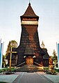
Wooden church

Denkmak JP II

Pogórze Bukowińskie

Pogórze Bukowińskie


.jpg)

Web links
Białka Tatrzańska | Brzegi | Bukowina Tatrzańska | Czarna Góra | Groń | Jurgów | Leśnica | Rzepiska