Grone (Göttingen)
|
Grone
City of Göttingen
Coordinates: 51 ° 32 ′ 4 ″ N , 9 ° 54 ′ 2 ″ E
|
|
|---|---|
| Height : | 148–222 m above sea level NN |
| Area : | 8 km² |
| Residents : | 11,951 (Dec. 31, 2018) |
| Population density : | 1,494 inhabitants / km² |
| Incorporation : | 4th July 1964 |
| Postal code : | 37081 |
| Area code : | 0551 |
|
The districts of Göttingen
|
|
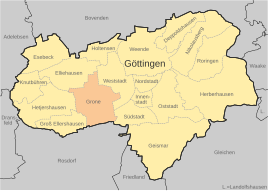
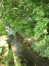
Grone is a district of the university town of Göttingen , which lies in the west of Göttingen in the plain of the Leinetal, from which the flat Egelsberg rises towards the city between Grone and the Leine . The Grone river of the same name flows through the village , into which the Rehbach flows in the center of the village. To the west of the populated area, Autobahn 7, running in north-south direction, cuts through the local area before the terrain rises west of the village to the Dransfeld plateau.
history
The area of today's Grone has been settled since the early Neolithic , as numerous sites of the band ceramic culture show. One of these sites is the Bandkeramische Siedlung Göttingen-Grone , which was extensively excavated by the Göttingen City Archeology department during the construction of a shopping center in the 1990s . There are also isolated traces of settlement in the Iron Age . During the Second World War , bombs fell on Grone during an air raid on January 1, 1945. A house in Lütjen Steinsweg was destroyed and five people were killed. The imperial palace of Grona was located northeast of Grone .
Local development since incorporation
Until the incorporation , which came into force on July 4, 1964, Grone was an independent village. As the city grew, the two places merged; in addition to the old town center, there are now the areas Grone-Nord and Grone-Süd. The Kasseler Landstrasse, which connects the A 7 with the downtown area of Göttingen, separates Grone-Süd from the other parts.
In the north or north of Grone, on the site of the former military airfield, there is a large industrial area that is growing steadily due to the influx of industrial companies ( e.g. Lambda Physik , Sartorius AG , Nanofilm Technologie GmbH , Trinos ). Several shopping centers attract visitors from the city and district. Historic companies such as Saline Luisenhall , the last European pan boiler, are based in Grone.
The residential area in Grone-Süd had developed into a social hotspot since it was built and thus got a bad reputation among the population. For some years now, this social hot spot has been alleviated through integration projects. Gradually, attempts are being made to improve the situation through projects by the EU , the federal government , the state of Lower Saxony , the city of Göttingen and the local council of Grone.
A double murder of two women on the “Zollstock” street made headlines across the country in September 2019.
Place name
In the old form the name Grone is called "Gronaha" (Grone = green, aha = ache = water). It is a transfer to the place and has its origin in the green vegetation of the stream. In Low German, the people of Gron were also called the "Chreunschen", meaning the Greens. The soccer teams of FC Grone still wear green and white clothing today.
Population development
Development of the population in Grone:
|
|
literature
- Hermann Danne: The history of the village of Grone based on its street, field and forest names. Series of publications by the Lower Saxony Heimatbund e. V. 17 (Oldenburg 1938).
Web links
- Districts of the city of Göttingen at goettingen.de
- Grone in the Wiki Göttingen
Individual evidence
- ↑ Jochen Reinhard: The flat ceramic settlement Göttingen-Grone - On the status of the processing. In: Reports on the preservation of monuments in Lower Saxony 2007/3, ISSN 0720-9835 , pp. 107-109 ( Link ).
- ↑ Martin Heinzelmann: Göttingen in the air war , p. 47f. Goettingen 2003
- ↑ Göttingen Law ( Memento of the original dated February 20, 2013 in the Internet Archive ) Info: The archive link was inserted automatically and has not yet been checked. Please check the original and archive link according to the instructions and then remove this notice. (PDF; 12 kB)
- ^ Heinrich Hampe: The population development of Grone . In: Göttinger Jahrbuch . tape 1 , 1952, ISSN 0072-4882 , p. 25 .
- ↑ City of Göttingen - Statistics and Elections Department: City of Göttingen: Historical population figures - Population in the city districts from 1896 to 2018. (PDF) In: Göttinger Statistisches Informationsystem - GÖSIS. City of Göttingen, March 1, 2019, accessed on December 28, 2019 .


