
Gudendorf (Cuxhaven)
|
Gudendorf
Godendkörper ( Low German ) City of Cuxhaven
|
|
|---|---|
.png) |
|
| Height : | 8 m above sea level NHN |
| Area : | 4.38 km² |
| Residents : | 309 (1950) |
| Population density : | 71 inhabitants / km² |
| Incorporation : | July 1, 1968 |
| Incorporated into: | Altenwalde |
| Postal code : | 27478 |
| Area code : | 04723 |
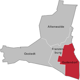  Location of Gudendorf within the village of Altenwalde
|
|
 Gudendorf as an exclave of the Hamburg exclave Ritzebüttel 1394–1937
|
|
Gudendorf ( Low German Godendbod ) is the southern part of the Altenwalde district of Cuxhaven in Lower Saxony .
history
Gudendorf and Franzenburg were first mentioned as a small community around 1800. It was not until around 1890–1900 that Gudendorf developed to a large extent from Altenwalde.
The communities Arensch , Berensch , Cuxhaven, Döse , Duhnen , Groden , Gudendorf, Holte , Insel Neuwerk , Oxstedt , Ritzebüttel , Sahlenburg , Spangen , Stickenbüttel , Süder- and Westerwisch belonged to the Hamburg office of Ritzebüttel until 1864 and then to the Ritzebüttel estate . In 1926 the municipalities of Arensch, Berensch, Duhnen, Groden, Gudendorf, Holte, Insel Neuwerk, Oxstedt, Sahlenburg, Spangen, Stickenbüttel, Süder- and Westerwisch became part of the Hamburg rulership. With the Greater Hamburg Act from April 1, 1937 were the municipalities Arensch, Berensch, Gudendorf, Oxstedt, Sahlenburg, Holte and bracelets on county land Hadeln , district of Stade of the Prussian province of Hannover .
Approx. Around 1750 a sheepfold was built in Gudendorf, which was restored for the first time in 1850 and was later considered a historical building, as it was the oldest building in Gudendorf. Around 1890–1900 the building was restored a second time, but very sloppily, which is why it collapsed in 1950 and the remains of the building were disposed of and burned.
Around 1930 a bathing establishment with changing rooms was opened in Gudendorf , right next to it a large sports and playground on the five mountains, because Gudendorf had a second large increase in population at this time. In the summer of 1946, the bathing establishment was torn down, the pools emptied and filled in, as the wood used as firewood was needed in the post-war period and there were no visitors. The outdoor pool was located at today's Schützenplatz, next to the “Auf dem Berge” road.
Incorporations
On July 1, 1972, the Altenwalde community was incorporated into the city of Cuxhaven.
Population development
| year | 1866 | 1871 | 1910 | 1925 | 1933 | 1939 | 1950 |
|---|---|---|---|---|---|---|---|
| Residents | 143 | 133 | 131 | 159 | 176 | 181 | 309 |
(Sources: 1866–1871, 1910, 1925–1939, 1950)
politics
Local councilor and mayor
Gudendorf is represented by the local council of the Altenwalde district of Cuxhaven.
coat of arms
|
|
Blazon : “ Split ; in front:a silver long-stemmed anchor cross in red ; back: in silver a blue heather sickle with a red handle, crossed by a peat spade with a blue leaf and a red handle. " |
| Establishment of the coat of arms: Since the 14th century, the Neuenwalde monastery acquired the manorial power over the whole of Gudendorf. The anchor cross from the old monastery seal symbolizes this affiliation. Heidsichel and peat spade indicate the location of the place and the economic activity of its residents. |
Culture and sights

Buildings
- Gudendorf is in possession of the “prehistoric grave”, which was found around 30 years ago. The grave is geographically: 53 ° 48 '14.70 "N and 8 ° 40' 18.91" O .
- The Bürgergarten is located next to the grave above
societies
Gudendorf owns several clubs, on the one hand the shooting club “Freier Wildschütz e. V. “and on the other hand the volunteer fire brigade, as well as the fishing club Land Hadeln e. V. with attached fishing lake.
Personalities
People connected to the place
- Karl-Arnold Eickmeyer (1925–2007), teacher, politician (SPD), member of the Bundestag (1977–1983 and 1985–1987), was headmaster in Gudendorf (1957–1967)
Web links
Individual evidence
- ↑ a b c Federal Statistical Office (Hrsg.): Official municipality register for the Federal Republic of Germany . Final results according to the September 13, 1950 census. Volume 33 . W. Kohlhammer Verlag, Stuttgart / Cologne August 1952, p. 49 , col. 1 ( digital version [PDF; 26.4 MB ; accessed on July 6, 2019] Landkreis Land Hadeln, p. 58).
- ^ Law on Greater Hamburg and other area adjustments. Art. 1 (RGBl. 1937 I p. 91). In: www.verfassungen.de. January 26, 1937, archived from the original on September 6, 2017 ; accessed on October 15, 2018 .
- ^ Federal Statistical Office (ed.): Historical municipality directory for the Federal Republic of Germany. Name, border and key number changes in municipalities, counties and administrative districts from May 27, 1970 to December 31, 1982 . W. Kohlhammer, Stuttgart / Mainz 1983, ISBN 3-17-003263-1 , p. 241 .
- ↑ Statistical Bureau of the Tax Deputation (ed.): The city of Hamburg, the suburbs, municipalities, localities and independently named areas of the Hamburg state . Otto Meissner Verlag, Hamburg 1875, p. 85 ( digitized in Google Books [accessed July 10, 2019]).
- ^ Ulrich Schubert: Municipal directory Germany 1900 - Landherrenschaft Ritzebüttel. Information from December 1, 1910. In: www.gemeindeververzeichnis.de. February 3, 2019, accessed April 15, 2019 .
- ↑ Michael Rademacher: German administrative history from the unification of the empire in 1871 to the reunification in 1990. Landkreis Land Hadeln (→ see under: No. 14 ). (Online material for the dissertation, Osnabrück 2006).
- ^ Rudolf Lembcke: Land Hadeln district. Past and present . Ed .: District of Hadeln. Buchdruckerei Günter Hottendorff, Otterndorf 1976, p. 25 (part of the coat of arms).
Altenbruch | Altenwalde (with Franzenburg , Gudendorf and Oxstedt ) | Berensch-Arensch (with Arensch and Berensch ) | Cuxhaven | Doze | Duhnen | Groden | Holte braces | Lüdingworth | Sahlenburg | Stickenbüttel | Süderwisch-Westerwisch