
Altenwalde
|
Altenwalde
Olenwoold ( Low German ) City of Cuxhaven
|
||
|---|---|---|
 |
||
| Height : | 0 m above sea level NHN | |
| Area : | 25.05 km² | |
| Residents : | 6158 (May 19, 2018) | |
| Population density : | 246 inhabitants / km² | |
| Incorporation : | July 1, 1972 | |
| Postal code : | 27478 | |
| Area code : | 04723 | |
Location of Altenwalde in Lower Saxony |
||
 Altenwalde in the city of Cuxhaven
|
||

Altenwalde ( Olenwoold in Low German ) is a district of Cuxhaven in Lower Saxony .
geography
location
Altenwalde lies on the edge of a glacial terminal moraine , the Hohen Lieth .
Local division
|
|
Districts | Area in km² |
|---|---|---|
| Altenwalde / Kernort | 9.47 | |
| Franzenburg | 3.21 | |
| Gudendorf | 4.38 | |
| Oxstedt | 7.99 |

Neighboring places
| Holte braces | Süderwisch-Westerwisch | Groden |
| Berensch-Arensch |
.svg)
|
Altenbruch |
| Nordholz - Spieka-Neufeld district (single municipality Wurster North Sea Coast) |
Nordholz (unitary community Wurster North Sea Coast) |
Lüdingworth Nordholz - Wanhöden district (unit municipality Wurster North Sea Coast) |
(Source:)
history


On the Altenwalder Höhe ( 37.5 m above sea level ) there was an old Saxon burial ground with urns from the 3rd to the 8th century. The area was built over with the Franconian- Carolingian Altenwalder castle from probably around 797. There was a - possibly Pilgrimage chapel of the Holy Cross and Willehad, already donated by Charlemagne . It was ailing in the 14th century and was demolished between 1590 and 1629
Altenwalde was first mentioned in a document as Wolde in 1282 . In the 13th century there were two churches that have not been preserved in Wolde: The parish church of St. Cosmas and Damian and the Chapel of the Holy Cross.
The Archbishop of Bremen had the Midlum Monastery relocated to Wolde. In 1324 the parishes of Wolde and Groden were pledged by Duke Erich I of Saxony-Lauenburg to Wolderich Lappe for 200 Hamburg marks. In 1334 the Altenwalde monastery was relocated to Neuenwalde . In 1348 the place was mentioned as Oldenwolde .
The Altenwalder School was founded in 1487. From 1590 the "Franzenburg" was built and the 357 hectare Franzenburg domain was created as a Vorwerk . The castle was occupied by imperial troops in 1632. In 1644 the facility was razed.
The Altenwalder Mühle (also known as the Klostermühle ) existed from 1535 to the 20th century. A millstone was exhibited on site.
In 1698 the city received the right to have a market. A free wood, junk and cattle market was allowed. The Kreuzkirche Altenwalde was badly damaged by the Christmas flood in 1717 . In 1789 the Romanesque parish church made of field stones had to be demolished and by 1791 a new classicistic hall church made of bricks was built on the old foundation walls.
In 1803 the area was occupied by French troops. Other occupiers until 1914 were British, Dutch, Prussians and Russians. In 1818 the first paved road was built in Altenwalde, in 1842 and up to 1855 further paving of the Chaussee was made, which was Reichsstraße 6 from 1937 and was expanded as Bundesstraße 6 in 1960; since 1981 Landesstrasse 135.
The communities Arensch , Berensch , Cuxhaven , Döse , Duhnen , Groden , Gudendorf , Holte , Neuwerk , Oxstedt, Ritzebüttel , Sahlenburg , Spangen , Stickenbüttel , Süder- and Westerwisch belonged to the Hamburg office of Ritzebüttel until 1864 and then to the Ritzebüttel estate . In 1926 the municipalities of Arensch, Berensch, Duhnen, Groden, Gudendorf, Holte, Insel Neuwerk, Oxstedt, Sahlenburg, Spangen, Stickenbüttel, Süder- and Westerwisch became part of the Hamburg rulership. With the Greater Hamburg Act from April 1, 1937 were the municipalities Arensch, Berensch, Gudendorf, Oxstedt, Sahlenburg, Holte and bracelets on county land Hadeln , district of Stade of the Prussian province of Hannover .
In 1932 Altenwalde was assigned to the Land Hadeln district . The extensive settlement of people who have been displaced from their homeland gives Altenwalde new impetus in trade and craft. In 1957 the German Armed Forces opened their new locations in Altenwalde and Oxstedt.
Incorporations
On July 1, 1968, the formerly independent communities Franzenburg, Gudendorf and Oxstedt were incorporated into the community of Altenwalde.
On July 1, 1972, Altenwalde was incorporated into the city of Cuxhaven .
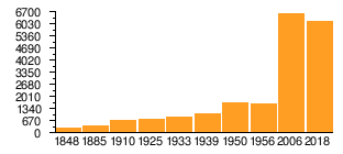
Population development
| year | 1824 | 1848 | 1885 | 1910 | 1925 | 1933 | 1939 | 1950 | 1956 | 2006 | 2018 |
|---|---|---|---|---|---|---|---|---|---|---|---|
| Residents | - ¹ | 303² | 419 | 683 | 753 | 905 | 1062 | 1659 | 1621 | 6603 | 6158 |
| source |
¹ 58 fireplaces
² in 63 houses
|
politics
Local council
The local council of Altenwalde consists of two councilors and nine councilors from the following parties:
- SPD : 6 seats
- CDU : 3 seats
- Greens : 1 seat
- The Cuxhaveners : 1 seat
(Status: local election September 11, 2016)
Local mayor
The local mayor of Altenwalde is Ingo Grahmann (SPD). His deputy is Silke Karallus (SPD).
coat of arms
|
|
Blazon : “In gold on a green arched shield base, three green fir trees ; the base of the shield is covered with a silver urn . " |
| Reasons for the coat of arms: The terms “old” and “forest” are symbolized by the hill with the urn and the three fir trees. The hilltop, known as Altenwalder Burg , is the site of numerous urns that indicate early settlement. |
Town twinning
Culture and sights
Buildings
- Classicistic Kreuzkirche Altenwalde from 1791 in the center on a small hill on the field stone foundation walls of a Romanesque church from the 13th century. At the time there were two churches that were not preserved: the parish church of St. Cosmas and Damian and the chapel of the Holy Cross and Holy Willehad . The Heiligkreuzkirche with an unknown location must have been abandoned between 1590 and 1629.
- Former Altenwalder castle on Altenwalder Höhe from the 9th century (above Karl-Grote-Platz) was mentioned in 1282. Only remnants of the rectangular ramparts have been preserved.
Nature reserves

Regular events
- Every two years: Altenwald village festival
- "3-fir tournament" (football)
- Every April 30th of the year "Tanz in den Mai"
Economy and Infrastructure
Numerous resident companies shape the town center.
The youth center "Dom" is located in the parish hall of the Evangelical Lutheran parish in the Bürgerpark.
The Franzenburg elementary school and a secondary school (Geschwister-Scholl-Schule) are on site.
Altenwalde runs through the former Bundesstraße 6 , today Landesstraße 135. The station on the Bremerhaven – Cuxhaven railway line was given up in 1991.
See also
literature
- Karl Lohmeyer : The castle on the Altenwalder Höhe and the ramparts of the Altenwalder Heide . In: Men from the Morning Star (ed.): Yearbook of the Men from the Morning Star . tape 27 (1934/35) . Self-published, Bremerhaven 1936 (124 pages).
- Fritz Hörmann, Ude Meyer, Christian Morisse, Eberhard Nehring, Irmgard Seghorn, Egon Stuve, Else Syassen: Wesermünde field names collection - the field names of the property tax cadastre from 1876 . Ed .: Kulturstiftung der Kreissparkasse Wesermünde (= new series of special publications by the men from Morgenstern , Heimatbund an Elb- und Wesermuende eV Volume 27 ). Men from Morgenstern Verlag, Bremerhaven 1995, ISBN 3-931771-27-X , p. 1 ([ digitized version ( memento of October 26, 2007 in the Internet Archive )] [PDF; 431 kB ; accessed on October 23, 2019]).
Web links
Individual evidence
- ↑ a b c d Statistisches Bundesamt Wiesbaden (Ed.): Official municipality register for the Federal Republic of Germany - 1957 edition (population and territorial status September 25, 1956, for Saarland December 31, 1956) . W. Kohlhammer, Stuttgart 1958, p. 187 ( digitized version ).
- ^ A b Heike Leuschner: The districts at a glance. Twelve in one go . In: Nordsee-Zeitung . May 19, 2018, p. 31 .
- ↑ Overview map of the Cuxhaven district. In: cuxland-gis.landkreis-cuxhaven.de. November 2016, accessed August 16, 2020 .
- ↑ Parish encyclopedia : Altenwalde .
- ^ Law on Greater Hamburg and other area adjustments. Art. 1 (RGBl. 1937 I p. 91). (No longer available online.) In: verfassungen.de. January 26, 1937, archived from the original on September 6, 2017 ; accessed on August 15, 2020 .
- ↑ a b Fritz Hörmann, Ude Meyer, Christian Morisse, Eberhard Nehring, Irmgard Seghorn, Egon Stuve, Else Syassen: Field names collection Wesermünde - the field names of the property tax cadastre from 1876 . Ed .: Kulturstiftung der Kreissparkasse Wesermünde (= new series of special publications by the men from Morgenstern , Heimatbund an Elb- und Wesermuende eV Volume 27 ). Men from Morgenstern Verlag, Bremerhaven 1995, ISBN 3-931771-27-X , p. 1 ([ digitized version ( memento of October 26, 2007 in the Internet Archive )] [PDF; 431 kB ; accessed on October 23, 2019]).
- ^ Federal Statistical Office (ed.): Historical municipality directory for the Federal Republic of Germany. Name, border and key number changes in municipalities, counties and administrative districts from May 27, 1970 to December 31, 1982 . W. Kohlhammer, Stuttgart / Mainz 1983, ISBN 3-17-003263-1 , p. 241 .
- ^ Friedrich Jansen: Statistical Manual of the Kingdom of Hanover (= Statistical Manuals for the Kingdom of Hanover ). Helwing'sche Hofbuchhandlung, Celle 1824, p. 16 ( digitized version in the Google book search [accessed on August 16, 2020]).
- ↑ Friedrich W. Harseim, C. Schlüter: Statistical Handbook for the Kingdom of Hanover (= Statistical Handbooks for the Kingdom of Hanover ). Schlüter'sche Hofbuchdruckerei, Hanover 1848, p. 147 ( digitized version in Google Book Search [accessed October 29, 2019]).
- ^ A b c d Michael Rademacher: German administrative history from the unification of the empire in 1871 to the reunification in 1990. Landkreis Land Hadeln ( see under: No. 4 ). (Online material for the dissertation, Osnabrück 2006).
- ^ Ulrich Schubert: Register of local authorities Germany 1900 - Lehe district. Information from December 1, 1910. In: gemeindeververzeichnis.de. January 5, 2020, accessed May 18, 2020 .
- ↑ Altenwalde. In: Website Stadtwiki Cuxhaven / Cuxpedia. Accessed on April 15, 2019 (population in info box).
- ↑ a b Altenwalde local council. In: Website City of Cuxhaven. Retrieved April 16, 2018 .
- ^ Rudolf Lembcke: Land Hadeln district. Past and present . Ed .: District of Hadeln. Buchdruckerei Günter Hottendorff, Otterndorf 1976, p. 14 (coat of arms).
Altenbruch | Altenwalde (with Franzenburg , Gudendorf and Oxstedt ) | Berensch-Arensch (with Arensch and Berensch ) | Cuxhaven | Doze | Duhnen | Groden | Holte braces | Lüdingworth | Sahlenburg | Stickenbüttel | Süderwisch-Westerwisch