
Hausruckviertel
Coordinates: 48 ° 5 ' N , 13 ° 40' E

| Quarter and districts of Upper Austria |
|---|
 |
The Hausruckviertel (in community names also Hausruckkreis ) is a landscape in the south-western central region of Upper Austria . Named after the Hausruck ridge .
It represents one of the four historical quarters of Upper Austria , although the current demarcation occurs through the political districts that only emerged in the 19th century. While the western border of the Hausruckviertel has always been defined by the border with Bavaria (today the Innviertel ) that existed until 1779 , the eastern border was largely formed by the Traun until the 19th century .
Since the formation of the political districts in 1868, the quarters in Upper Austria no longer have a legal basis and are purely landscape names. The older district division , which was still based on the old quarters, was replaced.
With the old division of Upper Austria into four quarters, the Hausruckviertel was bounded in the west by the border with the districts in the Innviertel ( Braunau , Ried im Innkreis and Schärding ), in the south by the rivers Vöckla , Ager and Traun and in the north by the Danube .
The Hausruckviertel today comprises the city of Wels , Eferding and Grieskirchen in the center of Upper Austria , the Vöcklabruck district in the southwest and the parts of the Linz-Land and Wels-Land districts to the left of the Traun .
With the introduction of the term Upper Austrian central area as the “fifth quarter”, the area between the cities of Linz , Eferding and Wels is also included more.
photos

Landscape with cider trees near St. Marienkirchen an der Polsenz

Obst-Hügel-Land near Scharten in the Eferdinger Landl

Landscape near Taufkirchen an der Trattnach

Frankenburg am Hausruck with the Göblberg

The Attersee with Kammer Castle
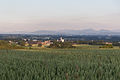
View of Schwanenstadt


.jpg)

See also
Web links
Innviertel |
Mühlviertel |
Hausruckviertel |
Traunviertel
Upper Austrian central area ("5th quarter")