
Hellberge (Eichsfeld)
The Hellberge are a hilly landscape in the Untereichsfeld in the district of Göttingen in southern Lower Saxony , which extends minimally into the district of Eichsfeld in north-western Thuringia .
location
Viewed clockwise, the hilly landscape of the Hellberge lies between Gieboldehausen in the north, Rhumspringe and Zwinge in the northeast, Jützenbach and Brehme in the southeast and Duderstadt in the southwest. The closest major city, Göttingen , is about 18 kilometers to the west. The former inner-German border ran over the southern edge of the hill country .
Natural allocation
The Hellberge belong to the main unit Eichsfelder Becken (no. 374) of the main group unit Weser-Leine-Bergland (no. 37) and bear the code number 374.3 or 374.30. Neighboring natural areas are the Rhumeaue in the northeast and the mountain range of the Rotenberg behind it , in the southeast the Bischofferoder Bergland , in the south the Ohm Mountains and in the southwest and west the actual basin landscape with the Golden Mark . The transition from the hilly landscape (374.30) to the Bischofferoder Bergland (374.31) runs smoothly without any sharp borders.
The Thuringian State Institute for Environment and Geology uses its own somewhat coarser structure that only exists nationwide, within which the red sandstone area in Thuringia is part of the North Thuringian red sandstone region .
nature
The hilly landscape, consisting entirely of red sandstone , is mainly used for agriculture, only a few small forest areas loosen up the landscape. In the southern part it forms a plateau-like landscape that is strongly structured by numerous valleys. A varied flora and fauna has developed in the area of the former inner-German border and is now part of the Green Belt .
The Hellberge are part of the following protected areas:
- LSG Untereichsfeld since 1989
- only a small part of the NSG border strip between Teistungen and Ecklingerode since 2000
- only a small part of the FFH forest area around Wenderhütte with Soolbachtal and Sonnenstein
mountains
The most important mountains and elevations from north to south include:
- Lohberg (228 m), south of Gieboldehausen, district of Göttingen
- Hellberg (259 m), west of Rüdershausen, Göttingen district
- Kuhhirtsberg (270 m), east of Obernfeld, LK Göttingen
- Wendenberg (290 m), west of Brochthausen, Göttingen district
- Tettelwarte (285 m), south of Breitenberg, LK Göttingen
- Haselbacher Berg (310 m), west of Jützenbach, Eichsfeld district
- Sulberg (226 m), north of Duderstadt, Göttingen district
- Bundsenberg (319 m), south of Fuhrbach, border area of the districts of Göttingen and Eichsfeld
- nameless (348 m), north of Brehme, LK Eichsfeld
- Fahrberg (292 m), east of Ecklingerode, Eichsfeld district
The most southerly mountains are to be seen as foothills of the Ohmgebirge or the Bischofferoder Bergland .
Waters
The hill country is delimited by the river systems of the Rhume and Eller in the northeast and the Hahle and Brehme in the west and southwest. It is the headwaters of numerous small tributaries that divide the hill country with its valleys (Hellbach, Betzelföhrbeek, Sulbig, Soolbach, Rahmkebach, Ibengraben).
Tourism
The hilly landscape is accessible through numerous hiking and cycling trails. From some mountain peaks (Tettelwarte, Wendenberg, Sulbergswarte) there are wide views over the Untereichsfeld to the Göttingen Forest and over the Rotenberg to the Harz Mountains . Sights include:
- Heinz-Sielmann nature experience center Gut Herbigshagen near Duderstadt
- Paterhof near Fuhrbach
- Sculpture woman with reef in Hilkerode
- Sulbergwarte north of Duderstadt
- Tillyeiche on the Hellberg
photos
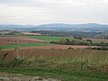
View from the Rote Warte over the hilly landscape to the Rotenberg and the Harz Mountains

View over the Herbigshagen estate towards Bundsenberg

Sulberg with Sulbergwarte
.jpg)
.jpg)

Individual evidence
- ^ E. Meynen and J. Schmithüsen : Handbook of the natural spatial structure of Germany - Federal Institute for Regional Studies, Remagen / Bad Godesberg 1953-1962 (9 deliveries in 8 books, updated map 1: 1,000,000 with main units 1960)
-
↑ Various authors: Geographical Land Survey: The natural space units in single sheets 1: 200,000 - Federal Institute for Regional Studies, Bad Godesberg 1963-1969 → online maps ;
- Sheet 99: Göttingen (Jürgen Hövermann 1963)
- Sheet 100: Halberstadt (Jürgen Spönemann 1970)
- ↑ In sheet 99 Göttingen (1963) 374.3 or the part on that sheet was shown as Hellberge ; Sheet 100 Halberstadt (1970), however, already lays the dividing line between Hellbergen (374.30) and Bischofferoder Bergland (374.31) on the section of the Göttingen sheet .
-
^ Walter Hiekel, Frank Fritzlar, Andreas Nöllert and Werner Westhus: The natural spaces of Thuringia . Ed .: Thuringian State Institute for Environment and Geology (TLUG), Thuringian Ministry for Agriculture, Nature Conservation and Environment . 2004, ISSN 0863-2448 . → Natural area map of Thuringia (TLUG) - PDF; 260 kB → Maps by district (TLUG)
- ↑ Map services of the Federal Agency for Nature Conservation ( information )