Helleberg (Westerwald)
| Helleberg
(Helteberg)
|
||
|---|---|---|
|
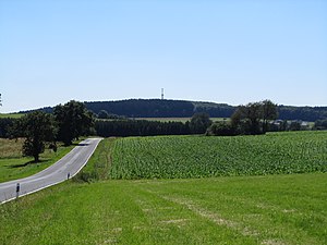
View from the north-northeast to the Helleberg with the observation tower and Kreisstraße 61 ( Rotenhain - Wölferlingen ) |
||
| height | 491.3 m above sea level NHN | |
| location | at Weidenhahn ; Westerwaldkreis , Rhineland-Palatinate ( Germany ) | |
| Mountains | Westerwald | |
| Coordinates | 50 ° 33 '10 " N , 7 ° 51' 27" E | |
|
|
||
| particularities | Helleberg observation tower and open-air stage | |
The Helleberg (also called Helteberg ) near Weidenhahn in the Rhineland-Palatinate Westerwaldkreis is 491.3 m above sea level. NHN high mountain of the Westerwald . The Helleberg observation tower and an open-air stage are located on it .
geography
location
The Helleberg is located between Wölferlingen and Düringen in the north, Haindorf and Obersayn in the east-south-east, Arnshöfen in the south-east, Weidenhahn in the south-west and Freilingen in the north-west; it is located in the municipality of Weidenhahn. The Westerwald Lake District extends a few kilometers north-northwest .
To the north and west, the wooded Helleberglandschaft falls down to the Sayn , to the southwest to the Steinchesbach tributary and to the southeast to the Kleiner Saynbach tributary to the Sayn .
Natural allocation
The Helleberg belongs to the natural spatial main unit group Westerwald (No. 32) and in the main unit Oberwesterwald (323) to the sub-unit Oberwesterwälder Kuppenland (323.1), whereby its landscape merges to the north and west to the nearby sub-unit Dreifelder Weiherland (323.2).
Protected areas
Southwest of the Helleberg summit, in the direction of Weidenhahn, and to the east, in the direction of Haindorf / Obersayn, are parts of the Westerwald bird sanctuary (VSG no. 5312-401; 289.48 km² ). In the east there are parts of the fauna-flora-habitat area Westerwälder Kuppenland (FFH-Nr. 5413-301; 31.87 km²)
Missile position, Helleberg observation tower and open-air theater
At the time of the Cold War there was an I FC representation of the nearby anti-aircraft missile position of the “4. Anti-aircraft missile battalion 23 Westerburg ”stationed.
A few meters northwest of the mountain peak, the Helleberg observation tower ( ⊙ ) was built in 1998 . From its viewing platform at a height of 521.3 m, large parts of the Westerwald (including the Westerwald Lake District ) can be seen in good visibility , and the view towards the Eifel , Vogelsberg and Taunus is also visible . Cell phone systems and a weather station are located above the platform .
In 2006, an open-air stage with a natural grandstand was built near the tower for events .
Traffic and walking
In the section Freilingen - Arnshöfen, federal road 8 leads about 250 m southwest of the mountain summit in a north-west-south-east direction over the high mountains, where it reaches a maximum height of 463.7 m . From this, at a height of 458.5 m , a cul-de-sac branches off to public traffic, which runs up to the summit region and serves hikers as a path to the summit.
Web links
- All-round view from the tower on panorama-photo.net (labeling can be activated), Internet Explorer users use the viewer
Individual evidence
- ↑ a b c d Helleberg in the landscape information system of the Rhineland-Palatinate landscape administration
- ↑ Map services of the Federal Agency for Nature Conservation ( information )
- ↑ "4. FlaRakBtl 23 “Westerburg (amateur radio pages from DB8PZ), on hps-computer.de
- ↑ a b c Helleberg observation tower , on ich-geh-wandern.de


