
Historical maps of the city of Bochum
Historical maps show the topographical conditions according to the state of cartography of their time. One of the oldest depictions of Bochum dates back to 1645.
17th and 18th centuries
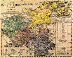
The map “Comitatus Marchia et Ravensberg” (Counties Mark and Ravensberg) comes from the atlas “ Atlas Maior ” by Willem Blaeu and Joan Blaeu ; it appeared in 1645. Nicolas Sanson drew the County of Mark in 1681.

Blaeu, 1645

Sanson, 1681


18th century
In 1755, Johann Gottfried Meinicke created a map entitled "Plan of the city of Bochum and the roads belonging to its jurisdiction". By Carl Arnold Kortum a floor plan of the city of Bochum dates from 1790; the original has been lost since 1954; Kortum himself resorted to the older so-called Kramer card.
Friedrich Christoph Müller drew the county of Mark in 1791 with its offices and mines ( topographic map of the county of Mark ). The surveyor Johann Friedrich Conrad Niemeyer created, among others, the Niemeyer map of Bochum in the years 1791 to 1793 on a scale of 1: 6640. There is still a copy of it from the time of the French occupation. It depicts farms, mills, mines, noble houses and streets very precisely.
In 1800 Johann Ehrenfried Honigmann published an edition on a scale of 1: 25,000 based on the Niemeyer's map.

Müller, 1791
Offices of the county of Mark, freely adapted from Müller, 1791

Kortum, 1790
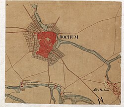
Niemeyer, 1792


19th century
The Prussian major general and cartographer Karl Ludwig von Le Coq published the map of Northwest Germany in 1805 , including a sheet for the Ruhr area on a scale of 1: 86,400. The Prussian General Staff Map (1816–1847) also has a scale of 1: 86,400.
A cadastral survey was carried out for the city of Bochum as part of the Prussian land survey between 1821 and 1825.
From 1819 to 1834 the Rhenish-Westphalian original cadastre was created as a cadastre for property tax.
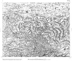
The Prussian premiere was made in 1830 and 1865. The result is the original table sheet from 1840 and overview maps for the recorded communities in the Bochum district . The city of Bochum has a number of historical community maps.
The urban area of Bochum was recorded for the first time by the following measuring table sheets :
- Sheet 4408: Gelsenkirchen, 1842
- Sheet 4409: Herne, 1842
- Sheet 4410: Dortmund, 1839
- Sheet 4508: Essen, 1842
- Sheet 4509: Bochum, 1840
- Sheet 4510: Witten, 1840
Friedrich August Volkhart, pastor and rector in Bochum, created a city map in 1842 on the basis of the documents from the cadastral survey.
The city of Bochum has a map from 1851 on a scale of 1: 5,000.
The Prussian New Admissions took place on a scale of 1: 25,000 between 1877 and 1915 .
In 1876 a new cadastral survey took place.
The "overview map of the city and district of Bochum" from 1877 by Keller has a scale of 1: 50,000. A map on a scale of 1: 10,000 was made by the surveyor Friedrich August Overhoff in the winter of 1884/1885.

Le Coq, 1805
Prussian General Staff Map, 1820

Original table sheet, 1840


20th and 21st centuries
The map of the German Empire ("General Staff Map ") was completed by 1909 on a scale of 1: 100,000. Various new editions of the measuring table map and the topographic map 1: 50,000 were made.
The German basemap on a scale of 1: 5,000 was created on paper for a long time. The Official Topographic-Cartographic Information System (ATKIS) has been set up nationwide since 1990 .
At times, the State Surveying Office of North Rhine-Westphalia published scanned topographic maps from different decades and centuries in a possibly transferred scale of 1: 25,000 on compact discs , which could be viewed in layers on top of one another, the Historika25 . The distribution was stopped. The tasks of the land surveying office were taken over by the Cologne district government .
In North Rhine-Westphalia, the topographic information management ( TIM-online ) provides topographic data for the public. Private information systems include Google Maps , Google Earth , OpenStreetMap and others.
See also
Individual evidence
- ^ Office for Geoinformation, Real Estate and Cadastre, City of Bochum: Historical Maps
- ^ Office for Geoinformation, Real Estate and Cadastre, City of Bochum: Historical maps of Bochum - original and redrawing from Kortum until today.
- ^ Office for Geoinformation, Real Estate and Cadastre, City of Bochum: Map of the coal seams in the county of Mark from 1800 by Honigmann.
- ^ Office for Geoinformation, Real Estate and Cadastre, City of Bochum: List of historical community maps.
- ^ Office for Geoinformation, Real Estate and Cadastre, City of Bochum: Plan of the city of Bochum from the years 1884 to 1885 by Overhoff.
- ↑ David Rumsey: Map of the German Empire.