
Hummelsberg (Westerwald)
| Hummelsberg | ||
|---|---|---|
.jpg) Hummelsberg, summit largely eroded by basalt mining |
||
| height | 407.4 m above sea level NHN | |
| location | Rhineland-Palatinate , Germany | |
| Mountains | Westerwald | |
| Coordinates | 50 ° 34'55 " N , 7 ° 19'30" E | |
|
||
| Type | extinct volcano | |
| rock | basalt | |
| Age of the rock | Oligocene | |
| particularities | Celtic ring wall (destroyed) | |

The Hummelsberg is an extinct volcano and is located six kilometers east of the city of Linz on the Rhine , to whose territory the mountain largely belongs. The smaller, eastern section belongs to the local community of St. Katharinen and is located in the Hargarten district .
There was a ring wall on the Hummelsberg , which dates from 600 to 400 BC. Is dated. It is the only known and studied weir of its kind in the Neuwied district. As a result of basalt mining, the mountain has lost around 35 m (summit) to 60 m (mining area) in height, the ring wall was destroyed in the process.
geography
The Hummelsberg is located in the Neuwied district in Rhineland-Palatinate on a ridge, the Rheinwesterwälder volcanic ridge , on the western edge of the Westerwald . The ridge forms the watershed between the Rhine and Wied . Today with its two remaining peaks of almost exactly the same height, 407.4 and 407.3 m above sea level. NHN high Hummelsberg had a height of 445 m before the basalt mining - in the Prussian new recording at the end of the 19th century it was 441.2 m above sea level. Measured above sea level - and was thus after the Meerberg (originally 448 m) the highest mountain in the region south of the Siebengebirge . Its two remaining peaks today, formed by edge pieces, are located on the Linz district to the south and east of the former mountain peak. In the vicinity of the Hummelsberg there are a number of other partly dismantled basalt domes.
Before the mountain was dismantled, the Hummelsberg, called the Hummelskopf until the beginning of the 19th century at the earliest , was divided into the Großer Hummelskopf and the Kleine Hummelskopf to the southwest , which had an elongated shape.
Geology and history

The basalt peaks in the eastern part of the Westerwald were created around 25 million years ago through volcanic activity. They tower over the plateau of the Rhenish Slate Mountains . The basalt found in the region is predominantly pentagonal to heptagonal, in some cases several meters long, columnar basalt.
The systematic and manual basalt mining on the Hummelsberg was probably started in 1855, initially by the Linzhausen- based company Gebrüder Wirtzfeld. The main buyers were the Netherlands, which used the basalt to fortify locks and coasts as well as to drain the Zuidersee. In 1888, Dutch and Rhenish quarry owners founded Basalt AG in Cologne , whose headquarters were relocated to Linz am Rhein in 1892 . The 16 quarries also included the Hummelsberg with the Hummelsberg I and Hummelsberg II quarries , while the Hummelsberg III quarry belonged to the Wirtzfeld company.
The transport to the Rhine was initially carried out by ox carts and horse-drawn carts, and later by cable car . In the 1870s, the first Bremsberg was built from Hummelsberg I to the Sterner Hütte in Linz. The mining at Hummelsberg I was stopped in 1963, then the other two quarries continued to be operated by Basalt AG from 1966 and finally stopped in 1984. The quarry that was left behind has now become part of nature again, and the deep pit has become a lake filled with surface water. The lake is not accessible.
Ring wall
In autumn 1936 and in spring 1937, the Rhenish provincial administration in Bonn carried out investigations on a weir system located on the mountain. At that time, an estimated five-sixths of the former ring wall had already been destroyed by basalt mining. It should be certain that the ring wall with a diameter of about 150 m surrounded the entire mountain peak, it was at a height of 430 m. The excavators found a flat stone wall, which consisted of the pending hard basalt and formed the toppling of a former wall. Up to five layers of stone remained from the front, made up of medium-sized stone blocks. Various indications suggest that the wall was criss-crossed by wood that stood vertically as well as that ran across and along the line of the wall. In addition, clay mortar was found to strengthen the wall. Buildings of this construction are called Gallic Walls . There were wall thicknesses of 3.5 to 5 m, at the gate even 7.5 m. From the amount of stone material, the researchers came to the conclusion that the wall was around 2.5 m high. A particular stroke of luck was that the part of the wall still existing at the time of the investigation was located in the gate of the ring wall. The gate passage was 3 to 3.5 m wide.
Individual finds suggest that the ring wall was not only used as a refuge, but also as a place to live. From vessel shapes and decorations it can be concluded that the ring wall on the Hummelsberg is to be assigned to the Hunsrück-Eifel culture and was in the period from 600 to 400 BC. BC served as a fortified hilltop settlement.
It should be noted here that the city wall of Linz am Rhein, built around 1350, was made of "stones from Hummelsberg". It should be stones from the ring wall that can still be seen today at the city gates of Linz.
Consequential damage
On December 2, 1978, a hundred meters high and two hundred meters wide rock wall collapsed into the lake below at the quarry that had already been disused. The water level rose by twenty meters and triggered a five-meter high scree and mud avalanche, which destroyed two houses in the “Schmitzhöfe” residential area below. Four people died.
Summit cross
A summit cross was first erected on the Hummelsberg on October 18, 1837 on the occasion of the 25th anniversary of the Battle of the Nations near Leipzig . It was 13 meters high and made of oak . As dismantling continued, it left its original location, was relocated several times and finally removed in the early 1940s. On one of the two new remaining peaks of the mountain further to the east - the height of which is 407.3 m above sea level. NHN is indicated - in the mid-1990s a summit cross was set up again by the Hargarten 1885 eV bachelor association. Like its predecessor, it is an oak cross, but at six meters it is significantly smaller.
See also

Column basalt on the Hummelsberg

Column basalt on the Hummelsberg
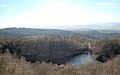
Quarry filled with surface water

Summit cross on the Hummelsberg


2.jpg)
Individual evidence
- ↑ a b c information according to digital topographic map 1: 5,000 (DTK5)
- ↑ Topographic map (1: 25,000) 1895, based on the Royal Prussian Land Survey 1893
- ^ Map of the German Empire 1: 100,000 - Bonn , 1898
- ↑ Heimat-Blatt and historical chronicle for the former Wied'schen and Nassauische Lande, for Westerwald, Eifel and Mittelrhein , 3rd year, No. 18 (October 11, 1924), Strüddersche Buchdruckerei und Verlagsanstalt, Neuwied 1924, p. 144. ( online )
literature
- District Neuwied (Hrsg.): Heimat-Jahrbuch 1979 District Neuwied
- Adalbert N. Schmitz: "Around the Hummelsberg. The association community Linz on the Rhine" 1984
- Parish of St. Katharinen (ed.); Heiner Strauss: St. Katharinen. Fest- und Heimatbuch , St. Katharinen 1994/2001, pp. 187-201.
Web links
- ( Page no longer available , search in web archives: biotope complex abandoned basalt quarry Hummelsberg near Hargarten )